As Victoria braced for the potential of catastrophic fire conditions on Friday January 9, 2026, much of the attention of media and community was understandably on the fires that were already threatening towns, farms and other human assets, especially the big fires around Walwa and Longwood.
Meanwhile, multiple fires were starting due to lightning in the high country. Some, such as near Mt Howitt and on the Bogong High Plains, were contained fairly quickly. However, one has gone on to burn a significant section of the high country. The Dargo – Wonnangatta Complex (also marked as the Mt Darling – Cynthia Range fire) is not yet under control. A Complex is named where there are multiple fires in close proximity, which can then be managed by a single incident team.
It seems that the fire started on monday night (5 January) at the top end of Wonnangatta Valley and was caused by lightning (multiple fires in the high country had started at similar times). According to reports posted on social media, Forest Fire Management Victoria (FFMV) crews went in to check it before 8am the following morning and started working on it straight away, with both aircraft and ground crews.
However, the fire took off rapidly, and according to reports was spotting well ahead of the main fire front once it got going. According to people in Dargo, a pyrocumulonimbus cloud was observable rising over the mountains to the north.
Firefighting operations
[scroll down for the latest updates on the fire]
Obviously Friday January 9 was a terrible day for Victoria. The major Longwood and Walwa blazes grew and multiple new and destructive fires developed in other places (such as at Harcourt in Central Victoria). In these circumstances, available resourcing would have been limited. FFMV reported that as the fire grew, they were allocating air, ground and rappel crews.
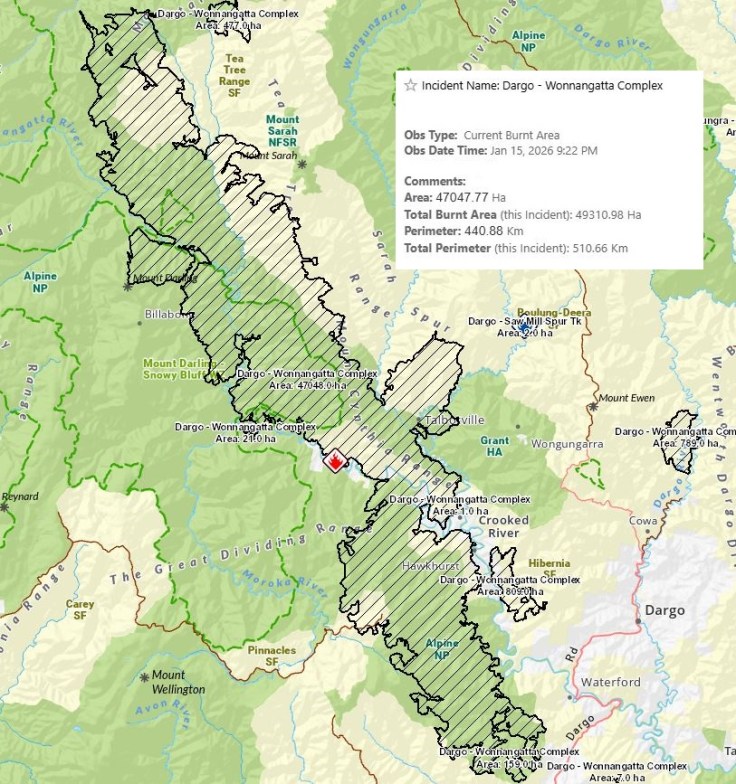
By the end of the weekend it had grown to around 41,000 hectares in size.
As conditions eased over the weekend, crews were able to contain a smaller spot fire east of Castleburn, which had already burned more than 600 hectares. is a priority for air, ground and rappel crews.
On Monday January 12, it was reported that
Firefighters are today working on creating and consolidating containment lines to protect Dargo, as well as fighting the southern end of the Dargo fire complex around Castleburn.
Incident controller Brett Mitchell, based in the Heyfield Incident Control Centre, said that
170 personnel working on the fire, with around 10 aircraft and over 40 pieces of heavy plant and equipment. Maps show a small number of aircraft mostly working on the southern edge of the fire.
VicEmergency Gippsland reports that:
Some of the heavy plant is being used to continue to construct control lines to protect private property around Dargo, Waterford and Castleburn Creek. Hazard tree assessment and treatment is occurring along the Wonnangatta Road area to support safe access. Crews are also continuing blacking out works and operations to protect critical infrastructure like communication towers.
Aircraft are also constructing control lines using retardant and targeting remaining hot spots. Daily and nightly linescans of the whole fire ground are happening which provide regular, high resolution mapping updates.
UPDATE: 12/1/26
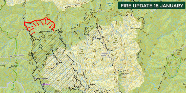
There is a seperate fire to the north east of the main fire, heading towards Mt Selwyn (and potentially the Upper Buckland valley). This was started by lightning at the same time as the Wonnangatta fire and is now included as part of the overall Dargo – Wonnangatta Complex. There are crews and machinery working on this fire.
Update 14/1/26
From VicEmergency:
Ecological impacts
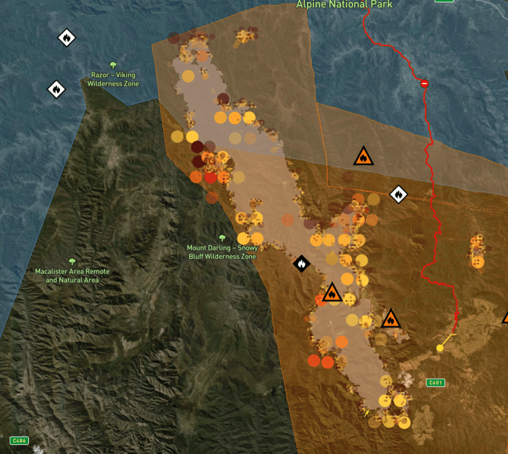
With fire operations still underway, it is too early to know what the ecological impacts will be. The main fire, which runs in a north to south axis, covers a lot of drier foothill forests, which are likely to recover well from fire. Thankfully the wind conditions have not pushed the fire towards higher ranges to the west, where fire damaged snow gum forests would be badly impacted by another blaze.
On the northern edge, the fire has crossed the Great Dividing Range and so will have burnt through both the alpine ash and snow gum country of the Barry Mountains. The intensity of this burn is not yet known.
Alpine Ash faces the prospect of widespread ecological collapse in the Victorian mountains because of the frequency of fires in recent decade. While the forest is regrowing from fire it is very vulnerable because a new blaze will likely kill off the forest if it is less than 20 years in age. The good news is that reports from controllers indicate that there is not a lot of young Alpine Ash in the Dargo fire footprint.
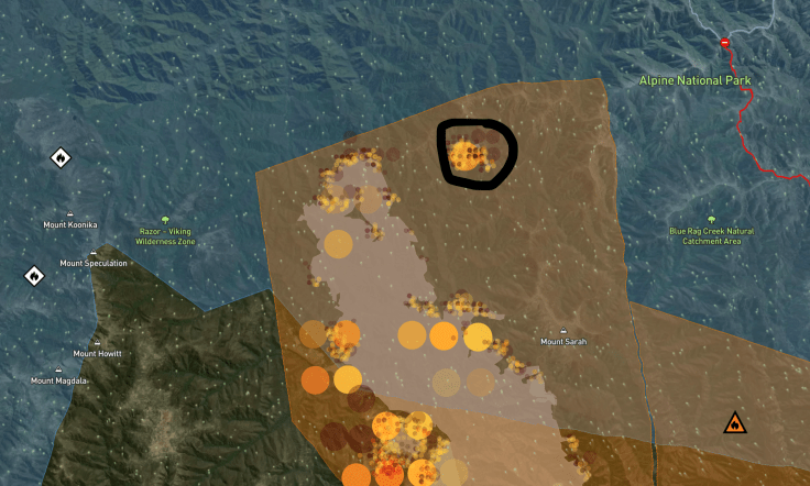
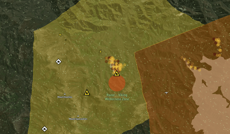
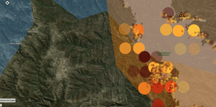
A worrying aspect of the fire is shown in the map below. It shows quite intense fire hotspots on the western edge of the fire (12/1/26). The pale tabletop area in the photo (below and to the right of Mt Howitt) is the Howitt Plains. This area contains significant stands of older snow gum forests and must be protected from fire. FFMV were criticised for being a bit slow to get onto a fire on the Howitt Plains in December 2024. Sections of the Howitt Plains have been badly impacted by previous fires in the 2000s and the area is in recovery. It is essential that wildfire is kept out.
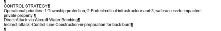
It is disappointing to see that the control strategy only mentions township protection, protection of critical infrastructure and safe access to impacted private property in its priorities. How can a major fire on public land, including the Alpine national park, not include protection of ecological assets (eg fire sensitive vegetation communities or animal species) as a priority?
What next?
The BOM forecast suggests that the area could potentially receive around 20 millimetres of rain on Wednesday14 January, a little bit more on Thursday and considerable rain on Saturday. So the approach of the incident manager will be to try to contain the fire within its current footprint and keep it away from local towns until then.
The eastern edge of the fire is complex, with multiple areas of fire activity. If conditions shift and the south westerly wind picks up, it could push towards very significant areas including the Dargo High Plains and Wongungarra Valley.
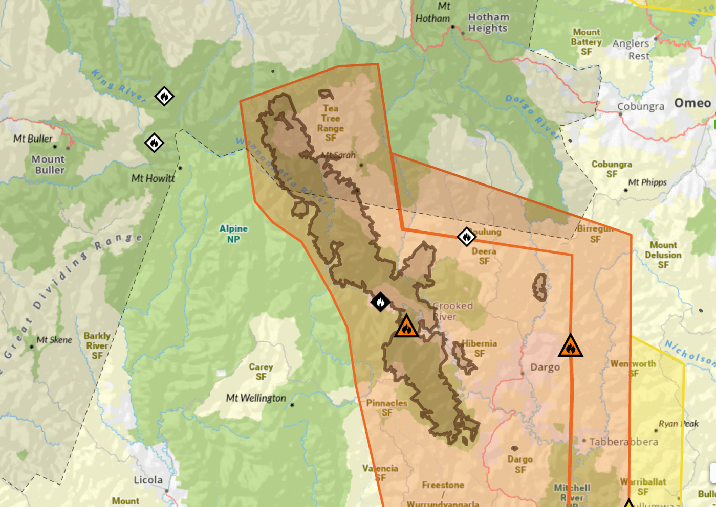
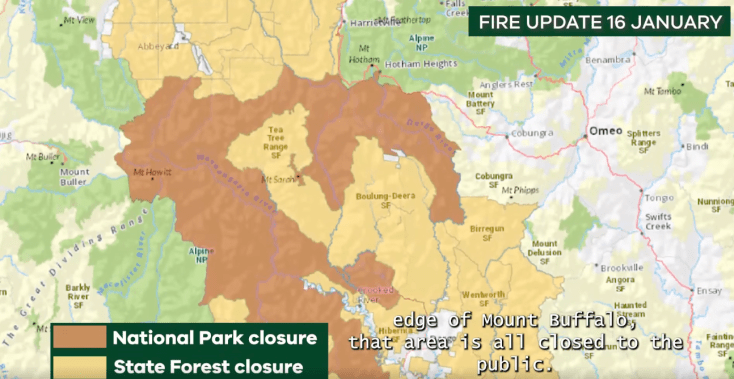
Closures
A Watch and Act warning remains in place for nearby communities, with residents warned to monitor conditions. (12/1/26).
The following Parks/Areas are closed to the public (current at 12 JAN):
- Blue Pool on Freestone Creek Road is Closed
- The Alpine National Park north of Briagolong, East of Arbuckle Junction and Mount Howitt, west of Dargo including the Wonnangatta, and south of Abbeyard, west of the Great Alpine Rd to Lake Cobbler is Closed.
- The Mitchell River National Park is Closed
The Dargo High Plains road is currently closed (12/1/26).
BELOW: current closures (17/1/26).
For further information check the following:
https://www.facebook.com/VicEmergencyGippsland


Leave a comment