The Olympus Range is located just south of those wonderful mountains that arc up to Mt Gould, the Labyrinth and the Ducane Range. They stand high above the surrounding plains and Lake St Clair and pose quite a challenge to approach.
The range has two key summits (Mt Olympus north and south, of similar height), some beautiful lakes and stands of deciduous beech, and should be on the list for any serious mountain enthusiast who enjoys a challenging walk.
It is possible to walk the entire range from Byron Gap to Cynthia Bay. You can also approach it from the west via Lake Petrach, and climb it as a day trip from Echo Point hut. These notes describe a 3 day walk that starts at Narcissus hut and finishes at Cynthia Bay (the southern end of the Overland Track). It is a half traverse of the range. You will need an additional day at the start to get to Narcissus.
A WORD OF CAUTION
This trip is a serious undertaking, only suitable for experienced hikers. There are substantial sections of boulderfields which must be traversed, and there is no defined track between Byron Gap and Lake St Clair. There are pads in some sections, but this trip requires good navigation skills. There are sections of thick scrub and a steep traverse as you descend from the peak.
I would recommend only doing this trip in good weather, with clear visibility.
THE ROUTE
Access the start of the walk from Cynthia Bay visitors centre at the southern end of the Overland Track in Cradle Mountain Lake St Clair national park. You will need to get to Narcissus hut, either by catching the hikers ferry service ($40/pp) or walking (roughly 5 hours).
DAY 1
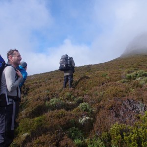
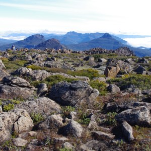
 Take the Overland Track South towards Echo Point hut. After about 2km take the well signposted track towards the Cuvier Valley (Lake Petrarch) which has a ‘caution track not maintained’ note as you join it. This climbs through wonderful old growth rainforest, passes many small streams and eventually traverses up into a more open forest dominated by snow gum. At the high point of Byron Gap, where there is a small clearing suitable for a campsite, you will see an obvious pad leading in the direction of Mt Olympus.
Head south here on the pad, entering the forest through an obvious gap/ door into the trees (there is usually a tape marker on a tree here) and head uphill. Skirt hikers left to get through the small cliff and make sure you’re on the pad, which tends to stick to the left side of the ridge, passing two other small cliff/ bench lines before emerging through the treeline into some great alpine country and hopefully wonderful views.
From here there are two options:
- Keep following the ridgeline towards the rocky, sharp highpoint above you (Lamonts Lookout), then along the ridge line to the northern summit of Mt Olympus (described as a ‘tedious’ boulder hop in the John Chapman/ Monica Chapman/ John Siseman guide to Cradle Mountain Lake St Clair National Park), or
- Sidle right, staying below the rocky peak, following the contour line through the alpine terrain, to approach the summit via a long boulder field.
We took the second option, which I assume is the slightly easier one. Description below:
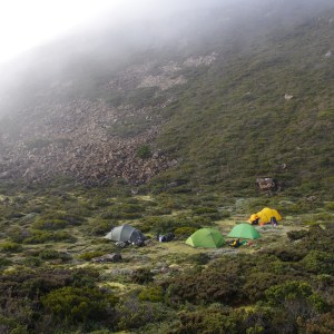
From the treeline, head towards Lamonts Lookout, then veer right to follow roughly the 1,200 metre contour line. As you walk past (under) the cliffs of the Lookout, you will see a number of benches/ hollows below you which will contain water and make for good camping. We stayed in the last one, it is quite sheltered from weather arriving from the south west. You will know when you get there as there is a large boulderfield blocking your route immediately ahead of you.
Allow 5 – 6 hours walking to get to this campsite from Narcissus hut.
DAY 2
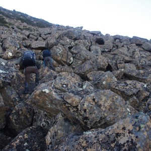
From camp, there is an obvious ridgeline and boulderfild blocking your route. Start climbing the boulderfield, to the initial high point, then via the easiest route to the top of the field. Allow about 90 minutes for this section. We found that as we climbed higher it was slightly easier if we veered right into the shallow gully. You will emerge eventually onto the top of the ridge, with Lamonts Lookout to your left and the summit another 10 mins scramble above you on your right. The views from here are superb. It will probably take around 90 minutes from camp to get to the ridge.
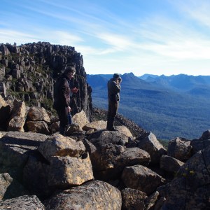
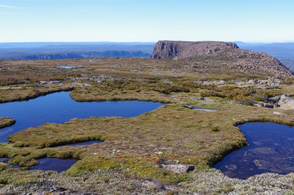
Take the final scramble to the summit plateau, then continue on towards the southern peak through a wonderland – completely alpine country, dotted with shallow tarns and with incredible views – to the far end of the summit plateau. Note that this is largely dominated by cushion plants so please fan out to minimise damage to these fragile plants.
If you do decide to camp up here, there is a grassy site (ie, less impact) at the far end of the summit plateau, just to the hikers left of the descent gully.
After a 20 min wander from the summit cairn, you will see the top of an obvious gully which is marked with a cairn: it’s the obvious descent point from the plateau. This is quite steep and has a bit of loose stone, so take care as you descend. At the bottom of the rocky section, the gully starts to open out and you will see an obvious ridge on your right (which runs from the summit plateau and divides the catchments of Lake Helen and Lake Oenone). You need to traverse right towards this.
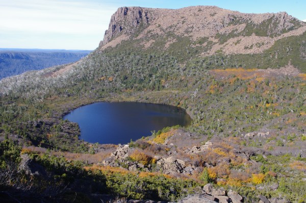
We found this section hard, without an obvious pad, and requiring steep travel through knee to chest height scrub. After about 500 metres of traverse you will reach the ridgeline and be treated to the luxury of a well worn pad. This high point of the ridge (which turns into cliffs higher up) marks the top point that many day walkers take, because it provides incredible views of Lake Oenone, and hence has more traffic.
Follow the ridgeline downhill past Lake Oenone. Its likely you will lose the pad as the ridge broadens out. You can either veer right here into the broad shallow valley that leads to Lake Oenone or continue out towards Lake St Clair. This area is a delight: a mix of old pandaniis, snow gums, and pencil pines.
There is sheltered camping at the lake. This area is reasonably popular as a day walk from Echo Point hut because of the extensive stands of deciduous beech, which turns colour in April.
From the bottom of the ridge, there are two options:
- Walk straight down the mountain to the hikers left of the outlet stream from Lake Oenone to emerge on the Overland Track about 2 km from Echo Point hut, or
- Cross the stream and traverse then descend directly to Echo Point hut.
We took the first option because it was more direct, involved less time ‘bush bashing’ and more time on track.
If, by now you have lost the pad, head to hikers right (ie towards the outlet stream) until you pick it up. You’ll be in an open area with snow gums, some deciduous beech, and open heathy sections. Soon, just before you cross the stream you should see a junction – veer right and cross the steam to go directly to Echo Point hut, or veer left to take the (recommended) direct route to the lake.
The direct route pad does braid at a couple of points but you should find it fairly easy to locate the main pad. There are very occasional small cairns but mostly you need to pay attention to stay on route.
After a lovely flat section, you will start the serious descent to the lake. The pad is much less distinct here and easy to lose, so its worth taking the time to locate it rather than keeping on going. At points it follows a stream bed. It passes through three cliff lines. The cliffs are the only points where it is clearly marked with pink tape. Take the time to find the safe descent option through each cliff, generally by turning hikers left along the top of the cliff. The larger cliff at the bottom requires a hand over hand descent using tree roots.
After the final cliff, its probably another 15 minutes steep downhill walking through forest before you emerge on the Overland Track. Turn right here – its about a 20 min walk to Echo Point.
Day 2 took us 9 hours, so plan to leave early. It would be hard to navigate the final section on the mountain in the dark.
DAY 3
Its about a 3 to 3 ½ hour walk from Echo Point hut to Cynthia Bay visitor centre.


Recent Comments