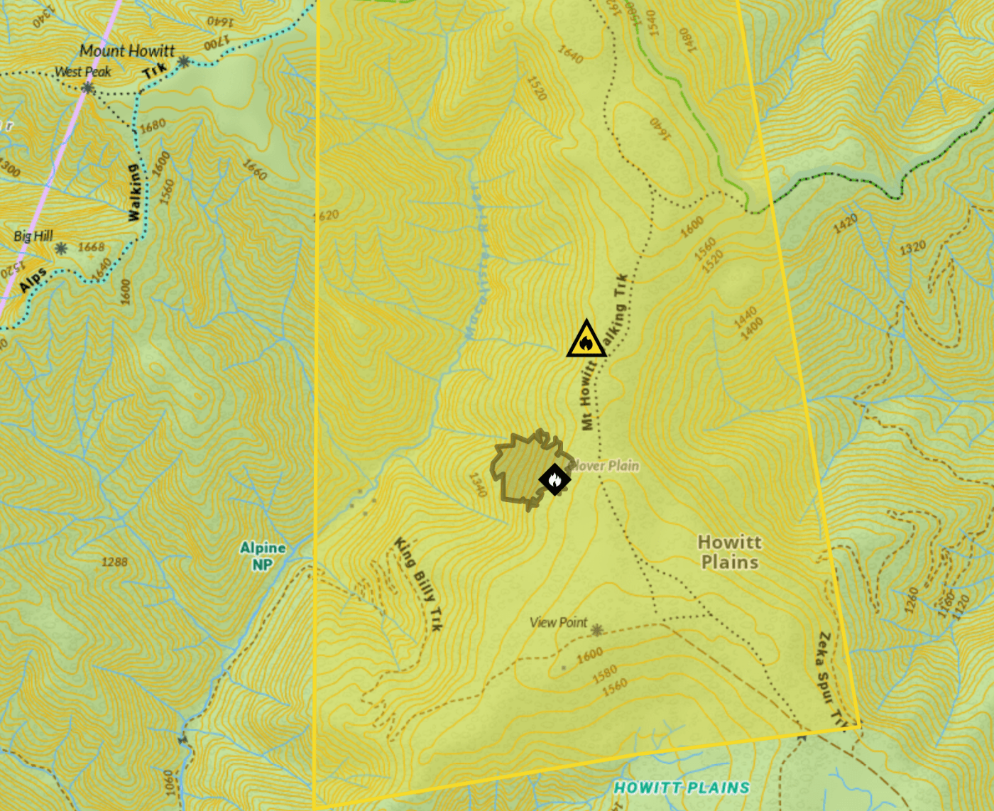
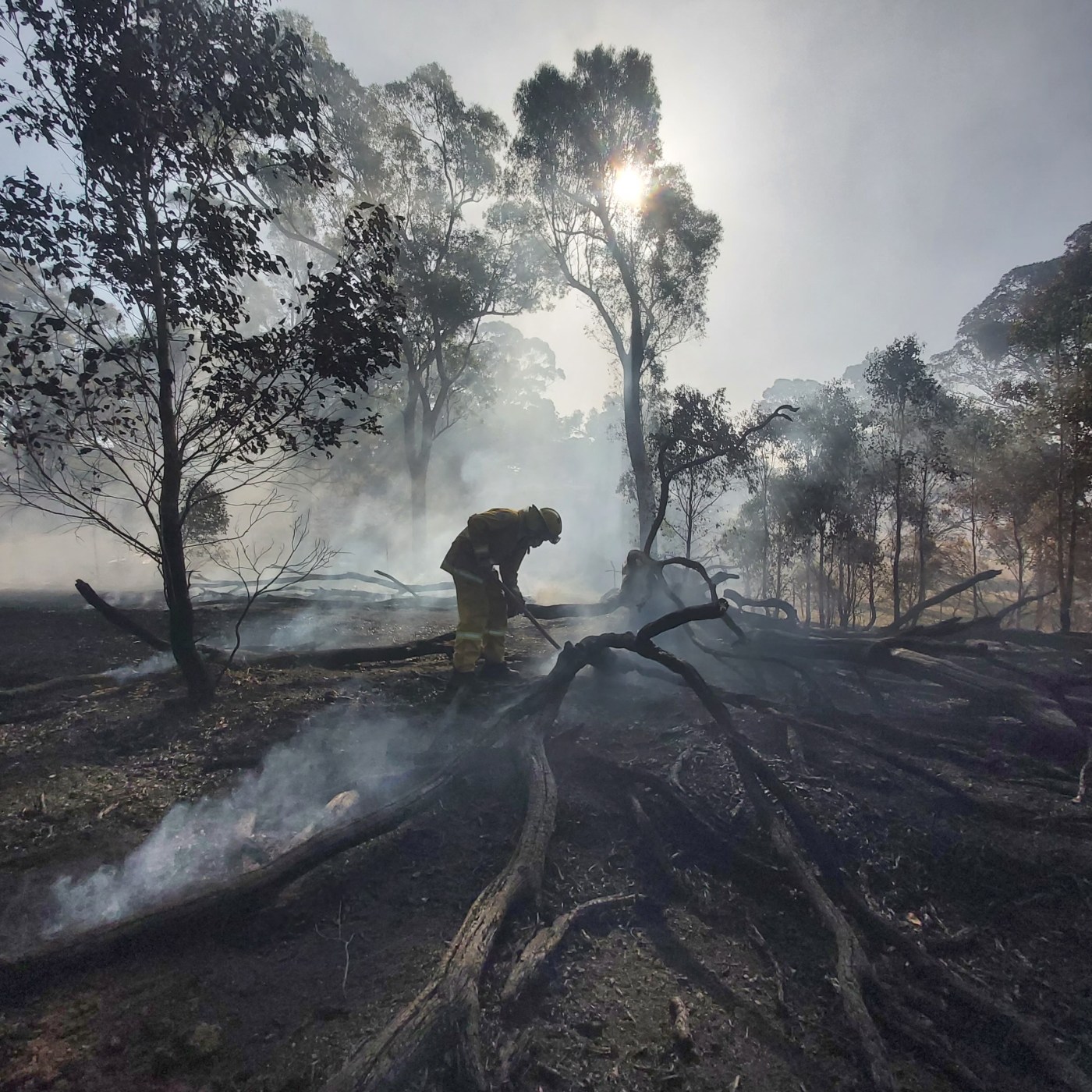
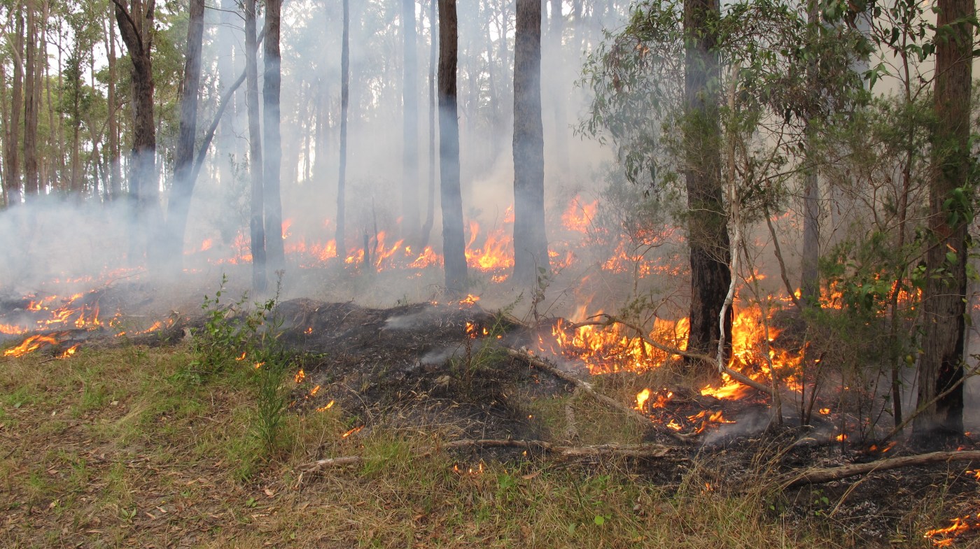
Search

Mountain Journal

Environment, news, culture from the Australian Alps

Celebrating International Mountain Day – in the lowlands

International Mountain Day is marked each year on December 11. This is one of those globally recognised events that often have an annual theme, and according to the Food and Agriculture Organisation of the UN (FAO), this year it is “Mountain solutions for a sustainable future – innovation, adaptation and youth”.

Out in central and northern Victoria, on the traditional lands of the Dja Dja Wurrung people, there are two sets of celebrations that will happen around the global day. The Dja Dja Wurrung are organising an event at Lalgambuk (Mt Franklin) on the 11th, and the folks from the Great Dividing Trail Network (who look after the trail that runs from Ballarat to Bendigo) are hosting a series of walks to different mountains between the 6th and 10th of December.

Continue reading “Celebrating International Mountain Day – in the lowlands”

Falls to Hotham Alpine Crossing update – November 2024

The plan by the Victorian government to upgrade the ‘Falls to Hotham Crossing’, a three day walk from the resort towns of Falls Creek to Hotham has been the subject of a long campaign by many environmental and outdoors groups and individuals because it is seen as a commercialisation of national parks. The plan, as originally pitched, was for several commercial accommodation ‘pods’ along the route, plus a major re-route of the walk to go up to Mt Feathertop. Government says ‘the walk is planned to be a multi-day hiking experience through the unique alpine environment, from Falls Creek to Mount Hotham.’

Faced with strong opposition, Parks Victoria is now proposing a scaled down version of the proposal, although notes that while they have not included overnight accommodation huts as part of the current proposed construction, ‘they do remain in the master”.

HEADER IMAGE: Artist impression of shelter at High Knob.

Continue reading “Falls to Hotham Alpine Crossing update – November 2024”

A new fire fighting team for Victoria

On Tuesday November 12, lightning started a fire in remote country north of Valencia Creek in the Victorian high country.

On Wednesday November 13, two rappel crews from Forest Fire Management Victoria (FFMV) were airlifted into the Avon Wilderness to fight the fire.

The crews created a mineral earth break around the fire and spent two days extinguishing hotspots before it was announced that the fire had been contained. In total the fire burnt around 1.3 hectares of forest. (Source: FFMV facebook).

This sort of early intervention is what is needed to stop small fires from turning into uncontrollable blazes.

Continue reading “A new fire fighting team for Victoria”

Black Summer biodiversity study suggests rethink of prescribed burns and fire management in Australia


This is not ‘new’ news. But it does add to the conversation that is underway about the role of prescribed burning (also called planned burning and fuel reduction burning) in terms of reducing fire risk.  

A new study examining plant and animal species after the Black Summer fire season has found greater biodiversity loss in areas that have been subject to frequent burning. Six ecosystems were considered, including alpine, wetland, rainforests and dry and wet eucalypt forest.

Sites with three or more fires in the 40 years leading up to the 2019–20 Black Summer were far more negatively impacted than previously unburnt areas or sites that had burnt once during that time.

Continue reading “Black Summer biodiversity study suggests rethink of prescribed burns and fire management in Australia”

Public Meeting – what future for the mountain?

Friends Of The Mountain is a coalition of community groups concerned with protecting and preserving the natural, cultural, historical, and Aboriginal values of kunanyi / Mt Wellington that have come together in response to the State Government’s “strategic” review of the Mountain and Wellington Park.

Come along to discuss what the mountain means to you, what you want for the future of the mountain, and hear what you can do to help protect the mountain from inappropriate development. please follow the link here to register your interest in attending this event.

We know how this story goes. But we could decide to change the ending.

We know that climate change is reducing the overall amount of snow we receive in Australia. The snow pack has been in decline since at least 1957. We also know that the loss of snow is being felt especially at lower elevations.

We also know that as snow pack dwindles and the snow line climbs up the mountains that we have already lost a number of previous centres of snow culture – like at Mt Buffalo where there used to be a small resort with ski runs, and people would ice skate on Lake Catani, while the famous Buffalo chalet provided great holidays in the snow in a beautiful setting. The old ski lifts at Buffalo have now been dismantled.

In the 1920s and 1930s people could ice skate on the lakes in Mt Field national park in lutruwita/ Tasmania, including at the famous Twilight Tarn and there was even a small outdoors ice rink on the summit of kunanyi/ Mt Wellington, above Hobart.

In the early 1900s, a popular ice-skating venue at the time, Pine Lake on the Central Plateau in Tasmania was chosen for the intention of establishing Tasmania as “the Switzerland of Australia” by establishing a “Ice yachting” venue (where specially built yachts could skim across the top of the frozen lake). Source.

The small resorts at Mt Mawson (Mt Field national park) and at Ben Lomond in the north east of the state really struggle to get enough snow cover to justify opening the ski tows.

Spring skiing in the mountains of lutruwita/ Tasmania was a thing up until the 1990s. Now good snow pack in the spring months is a rarity that must be grabbed if you have the chance.

Kiandra in the Snowy Mountains was the birthplace of skiing in Australia (as pointed out in this recent podcast from Protect Our Winters). Australia’s first T-bar lift had been installed on Township Hill near Kiandra in 1957. Now the valleys and hills around the old settlement rarely hold skiable snow for long.

Continue reading “We know how this story goes. But we could decide to change the ending.”

TAS Development Assessment Panels to take decisions away from local councils

There has been a long community-led campaign to oppose the plan to build a cable car up the face of kunanyi/ Mt Wellington, the mountain above Nipaluna/ Hobart. There is another important moment in the campaign.

The Tasmanian Government has now released the Development Assessment Panel (DAP) draft bill for comment. There are fears that, if passed, this legislation would mean that future Development Applications will be assessed by DAPs appointed by the Tasmanian Planning Commission rather than local councils.

Continue reading “TAS Development Assessment Panels to take decisions away from local councils”

What does the ‘State of the Climate’ report mean for mountain environments?

The biennial State of the Climate Report, which is produced by the CSIRO and BOM has now been released. The report draws on the latest national and international climate research, monitoring, science and projection information to describe changes and long-term trends in Australia’s climate.

Among a vast amount of information, there are some clear details relevant to mountain environments.

Continue reading “What does the ‘State of the Climate’ report mean for mountain environments?”

Mountain health snapshot

Much of the mountain country across south eastern Australia and lutruwita/ Tasmania is on protected public lands. While the ski resorts continue to intensify the impact of their existing footprint through continued building and infrastructure, across the undeveloped zones there are also a range of projects that threaten the health of ecosystems.

Seperately, each can feel insignificant. But when taken collectively the impact is enormous. This is a quick assessment of some of the big picture trends happening across the Alps and mountainous zones of Tasmania at present.

Continue reading “Mountain health snapshot”

Have your say: the Code of Practice for Bushfire Management on Public Land

The Victorian Department of Energy, Environment and Climate Action (DEECA) is updating the Code of Practice for Bushfire Management on Public Land (the Bushfire Code), and is calling for  feedback on the draft Code.

The Bushfire Code sets out objectives for the way DEECA manages bushfire on public land, including state forests and national parks.

The current Bushfire Code is more than 10 years old. It updating it to make sure it meets modern needs and expectations.

There is an online submission process which is open until November 3.

Continue reading “Have your say: the Code of Practice for Bushfire Management on Public Land”

The Bogong Moth summit

The Bogong moth (Bugung (Ngarigo), Deberra (Taungurung)) is an iconic Australian species, important to First Nations Peoples, critical to ecosystems along its migratory path and the Australian alps, and threatened with extinction. To secure the Bogong moth we need to understand its distribution and migratory flyways which is a major challenge because their distribution records span the full breadth of Australia, everywhere south of 25° latitude.

A Bogong Moth Summit is being organised and will be held in Canberra  over February 28 – 29. The summit’s primary aims are to inspire people to get involved in Bogong moth conservation and highlight their cultural and ecological importance.

Continue reading “The Bogong Moth summit”

Managing the grief

For the last few years, Friends of the Earth has been hosting guided walks in the high country to show people areas at risk from logging. These have included Mt Stirling, the upper Little Dargo River, and the stronghold of older snow gums that exists at Mt Wills and which would have been put at risk by logging that had been planned for Alpine Ash forests on the mountain.

With the government announcing an end to logging on public lands in the east of the state in early 2024, we shifted the focus of our walks onto snow gum woodlands, which are increasingly being impacted by climate change driven fire regimes and dieback caused by a native beetle.

In early 2024 we led a walk to visit what we called the ‘ghost forests’ of the high ridge between the Tawonga huts and Mt Fainter on the north western edge of the Bogong High Plains.

Continue reading “Managing the grief”

Blog at WordPress.com.

Up ↑