Celebrating International Mountain Day on Country: An Inspiration and Vision from Six Peaks Speak
Honorary Professor Barry Golding AM, Federation University, writes:
I had the huge privilege as a State Library Victoria Creative Fellow in 2023. I spent a whole year researching and writing a book about six modest mountains on Country near where I live in central Victoria. It was undertaken with the strong support of DJAARA for the Dja Dja Wurrung Traditional Owners. ‘Six Peaks Speak: Unsettling Legacies in Southern Dja Dja Wurrung Country’ published in 2024 on International Mountain Day (IMD, which is celebrated globally each year on 11 December) is my main tangible outcome. I am hopeful, like DJAARA, that future celebrations of other Australian mountains on Country might become an enduring legacy. This is my story and vision.
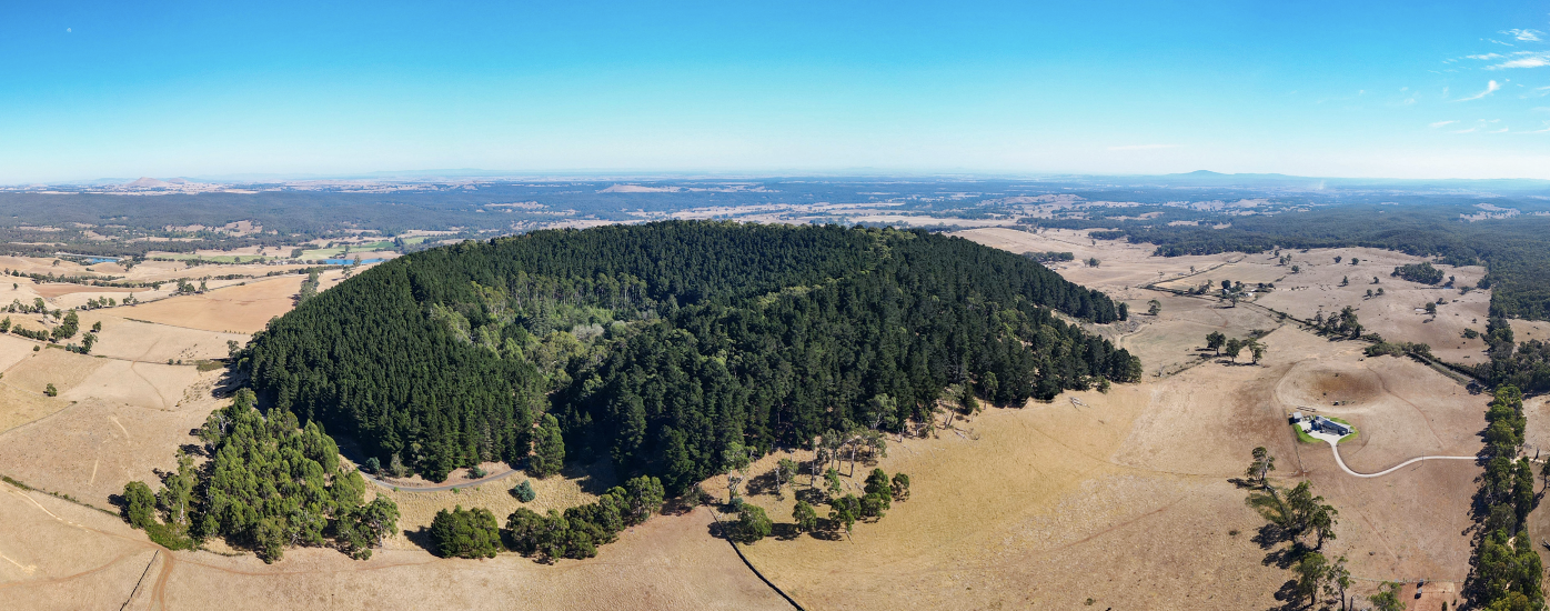
Header image: Lalkambuk / Mount Franklin’s pine covered, breached volcanic crater (Drone Photo: Oliver Zimmermann).
Six Peaks Speak adopted a ground-up, multidisciplinary perspective to tell the story of just six modest mountains out of 22,000 named peaks in Australia, from deep geological time to the present. While the peaks I selected are today called mounts Kooroocheang, Beckworth, Greenock, Tarrengower, Alexander and Franklin, each one also has a fascinating but rarely considered First Nations back story. Written with the invaluable assistance of coauthor, geologist and friend Clive Willman, our book sought to answer the question, ‘How can we help future generations deal with the unsettling legacies of what has happened to mountains?’
Unsettlement
I deliberately included unsettling in the title in our book. It challenges the false assumptions and attitudes in historical sources about the benign nature of ‘settling’, ‘discovery’, ‘exploration’ and ‘pioneering’ in an already comprehensively explored, settled, named and cultured continent. I personally experience the notion of ‘settlement’ in the context of colonization and copious evidence of attempted genocide in Australia as upsetting, disturbing and discomposing. Six Peaks Speak thus upends the comfortable and conventional idea of settling, instead using unsettling as one of its key organizing principles.
Mountains are important sentinels of change in Australian landscapes. All were managed and settled and have recently been unsettled. Few mountains were ‘wilderness’ in the modern sense. Some, like the ancient granite peaks in my home landscape including Dharrang Gauwa (Mt Tarrengower, near Maldon), Nyaninuk (Mt Beckworth, near Clunes) and Liyanganuk (Mt Alexander, near Harcourt) are what remains after hundreds of millions of years of erosion. Others like volcanic Lalkambuk (Mt Franklin, near Daylesford, see Figure 1), Mount Greenock (near Talbot) and Gurutjanga (Mt Kooroocheang, see Figure 4) are relatively recent ‘upstarts’; relatively young scoria cones which built up quite recently and quickly as a consequence of volcanism within the past 4 million years. A recent date for Lalkambuk (meaning ‘split head’) confirms the mountain’s exquisite, breached crater, which Dja Dja Wurrung people called Larne barramul, literally ‘nest of the Emu’, had formed as recently as 110,000 years ago.
This volcanic activity not only created hundreds of elevated scoria cones, which by virtue of their shape came to be known as mammaloid (‘breast-like’) hills and mountains. The lava spread downslope away from the peaks, flowing along valleys in every direction like honey, far and wide, burying gold bearing streams and gravels, typically creating two new streams where there had only been one. It is these fertile and well-watered lava plains and their ‘twin lateral steams’ in western and central Victoria which once supported some of the highest First Nations population densities in inland Australia.
The natural productivity of the rich soils developed on the lava plains was enhanced by regular and systematic First Nations burning, creating extensive grasslands carpeted by nutritious murnong (Yam Daisy) and grazed by countless herbivores. All of this changed in 1838 when squatters overlanded with sheep, forcefully and sometimes violently removing and excluding First People from Country. Settlement of Australia, was only possible if First Peoples were first unsettled. It is this unsettlement and what followed that each of the six mountains featured in our book have borne witness to.
Modest Mountains & Hills: All Different
Mountains, hills and the public reserves that sometimes surround them need not be as high or as expansive as those in the Australian Alps to be impactful, embraced and cared for by the local community, including by First Nations peoples. The locally loved Mt Jeffcott near Donald, where I was born in northern Dja Dja Wurrung Country in north western Victoria, is only 252 metres above sea level and 100 metres above the surrounding plain. The nearby rocky summit of the locally adored Mt Wycheproof, which stands just 42 metres above the surrounding plain and only 148 metres above sea level, is purported to be the smallest registered mountain in the world.
We often focus on a small number of high, iconic mountains which are on publicly reserved land, in part for their utility associated with nature conservation, but particularly for human visitation, such as providing opportunities to enjoy their elevated and scenic views, rock climbing, walking, snow skiing or enjoying plants and wildlife. It is useful and important as part of responsibly managing Australia’s 22,000 named peaks to better understand how mountains and the endemic species which they sometimes serve as refuges for, were created over Deep Time and settled by First People. While many smaller mountains and most hills in Australia are on private land, all have deep histories and cultural associations including with First Peoples, not only via their original names or as places to gather food, but as special and sacred places to assemble and conduct ceremony.
One thing I’ve realised since carefully studying these six peaks from a multidisciplinary, Deep Time perspective is that that all mountains are individual and different. Being in the landscape for much longer than humans, each mountain has been subjected to a range of unique influences and changes over very long time periods, including by erosion and deposition, changes in climate, volcanism and earth movement.
Some of these influences have been preserved on our peaks; others have been erased or hidden. Every gully and rocky outcrop on each peak is subtly different because of differences in slope, altitude, aspect, ecological and geological history. As a consequence, the animals, plants and fungi that call our peaks home are everywhere subtly different, something which First Peoples came to know and understand in order to live sustainably and thrive on and around mountains in Australia for at least 60,000 years.
Since writing Six Peaks Speak, I have come across palimpsest theory. The theory posits that objects and landscapes (including mountains) can be thought of as palimpsests (literally and metaphorically), able to concurrently contain and preserve evidence of multiple meanings as each new meaning is inscribed over past ones. The theory anticipates that some meanings may be conspicuous, while others might be erased or hidden. I suggest that the theory will also be useful in the future for identifying and restoring ancient First Nations associations on Country. It will also be useful for dealing with the layered, contested and evolving meanings and impact of mineral, sand and stone extraction, which often occurs on and around mountains and hills.
In order to illustrate what I mean, take a close look at the Digital Elevation Model (DEM) map (see Figure 2, below) that Clive Willman created for our book, which features the topography of the Six Peaks Region and its relationship to geology. Only six mountains featured in our book are named on this map, amongst the hundreds of other hills and mountains in this 80 x 80 km area. The grey areas are mostly ancient sedimentary rocks, which from the 1850s became ‘gold country’. Being relatively soft and erodible these areas form rugged, hilly terrain with few large mountains.
What is particularly striking are the prominent hornfels hills around most of the granite margins. The hornfels is more resistant to erosion since it was baked hard (metamorphosed) at great depth by the molten granite. Pink granitic areas feature ancient, often prominent mountains (similar to Mt Buffalo in Victoria’s northeast) and rolling hills. Pale brown areas are relatively flat and now fertile, very recent volcanic plains dotted with numerous elevated scoria cones (orange) and other eruption centres (black dots).
At this scale the relationship between topography, drainage and geology becomes strikingly obvious. The two 8-km radius circles enclose the 1840/1 Neura Mong and 1841/9 Loddon (Franklinford) Aboriginal Protectorates, sited on less fertile country of less interest to the squatting unsettlers than the first-seized volcanic plains.

Figure 2: Digital Elevation Model (DEM) showing the topography of the Six Peaks Region and relationship to geology (Map Credit: Clive Willman).
Zooming in to the area towards the north of the map, the geological map of the area around Mount Tarrengower (Figure 3) which includes roads, towns and mines illustrates the close relationship between post-contact settlement patterns and geology on a smaller scale. The western flank of Mount Tarrengower, being granite, has no mines and sparse settlement. By contrast, the summit of Mt Tarrengower is composed of resistant hornfels. All of the gold occurred either in the hornfels or within the ancient, folded sediments, unsurprisingly where the historic mining town of Maldon is located. While Cairn Curran Reservoir now obscures most of the evidence, the Loddon River has relatively recently been forced change its course by the basaltic lava.

Figure 3: Geological map of the area around Dharrang Gauwa / Mt Tarrengower (Map Credit, Clive Willman).
What is illustrated in these few examples can be extrapolated to most mountains and hills in Australia. They are elevated peaks today for a very good, often geological reason: either because they were more resistant to erosion over Deep Time, or because they have been created relatively recently by volcanism or earth movement. The ecological communities and patterns of human settlement on and around most mountains, pre- and post-contact, are also determined largely by geology.
International Mountain Day
While I was in Japan in 2023 taking a break from writing our book about six peaks, I discovered that Japan was one of very few countries in the world to actively adopt and celebrate the UNESCO International Mountain Day. The specific aim of its celebration in Japan since 2016 has been to encourage Japanese people to pay homage to and appreciate blessings from mountains, which are acknowledged as an important part of Japanese culture.
International Mountain Day was originally designated in 2003 by the United Nations as 11 December, to highlight the importance of sustainable mountain development. In Japan, 11 August was chosen instead, in part because some mountainous regions already celebrated their mountains on that day. It was also because the kanji character for eight (八) resembles a mountain, and the character for eleven looks something like two trees, symbolizing the landscape.
I wondered where the idea for celebrating International Mountain Day originated. I discovered that in autumn of 1838, women from one small college in the United States began an annual tradition of taking the day off and climbing nearby Mount Holyoke, which their College was named after. This tradition evolved into Mountain Day in several other US colleges, to eventually become International Mountain Day.
I discovered that 17,000 km away, at the same time in the same year, on the other side of the planet, squatter John Hepburn was forcefully removing Dja Dja Wurrung traditional owners from their carefully managed grasslands in Australia and renaming Gurutjanga (Mount Kooroocheang, see Figure 4), one of the six mountains featured in our book. For thousands of years, Dja Dja Wurrung people had been living semi-permanently on the fertile volcanic plains, at a place below the peak that Hepburn acknowledged was their ‘favourite place’. Countless generations had assembled and conducted ceremony here on a unique, purpose built 75 metre diameter earth ring, as well as in the Larni barramal crater surrounded by Lalkambuk’s ‘split head’ mountain rim, today called Mt Franklin.

Figure 4: Gurutjanga / Mt Kooroocheang in late summer 2023 (Drone Photo: Oliver Zimmermann).
In Hepburn’s eyes, Aboriginal people were simply getting in the way: like most other squatters, Hepburn behaved as if he owned the land, rather than just having a lease from the Crown for grazing his sheep. He was unaware that the people he was forcefully and sometimes violently removing for his sheep were largely responsible for creating and maintaining its agricultural productivity.
As Robert Lewis put it in Environmental history of Australia, squatters, who I accurately call ‘unsettlers’ in my book, took the view that since First Peoples ‘… seemed to be living off [the land] but not being productive, [they] did not have a rightful claim to it’. Violence was perceived as justified and necessary as part of the unsettling process whenever Dja Dja Wurrung people resisted the invasion.
The Sydney Herald in the same year, 1838, justified the violent seizure of land in Australia. They did this by comparing Aboriginal Australians with First Nations people in America in the most negative of ways, using claims that we now know are patently false, conveniently misconstrued and inhumane.
The American Indians were divided into Nations, having fixed localities – they cultivated the ground, and understood the right of property. Not so, however the natives of New Holland. This vast country was to them a common. They bestowed no labor upon the land – their ownership, their right was nothing more than the Emu or Kangaroo. They bestowed no labor upon the land, and that – and that only – it is which gives a right of property in it. (7 Nov 1838, p.2)
Given these false claims, I wondered how Mount Holyoke College in the US came to be named. I discovered that the mountain’s First Nations name was changed after English colonist Elizur Holyoke arrived in Massachusetts Bay Colony in 1637 or 1638. Like John Hepburn 200 year later, he had violently seized Nonotuck First Nations land to enhance his personal wealth. Renaming mountains was an important part of the colonial ‘settling’ agenda.
There were so many serendipitous parallels here of history repeating itself. And I figured celebrating International Mountain Day (IMD) on Dja Dja Wurrung Country in 2024 and beyond might provide a way of ‘thinking globally but acting locally’: of telling the story of mountains on Country. In the process of celebration, it would also provide an opportunity, in an era of truth telling, to expose many of the uncomfortable and lesser known legacies of how ‘things came to be like this’, and find ways in Australia of healing Country together as a community.
On IMD in 2023 I spoke about my Six Peaks Speak project and my future vision for celebrating International Mountain Day on Country. I invited several organisations which I thought might usefully collaborate. The 2024 IMD working party was headed up by DJAARA through its CEO Rodney Carter, also including Outdoors Victoria and the local Great Dividing Trail Association.
The idea of celebrating IMD on Country in 2024 was taken up enthusiastically by DJAARA. In their words:
Our Ancestors have told us of our beginning. It is ancient, and those stories talk of all creation through their Martinga Guli (Ancestral Spirits). On mountains, where colonial development is more limited, it is easier to hear their whispers, the language of Country. The wider community also feels this spirit that we nurture today through practising our Culture. International Mountain Day is a day to come together as one People and connect with Country. When we are spiritually connected to Country, we can feel its tears, we can hear its voice and continue to share its stories for thousands of generations to come.
On the morning on 11 December 2024, DJAARA warmly invited the community to ‘Immerse yourself in Dja Dja Wurrung Culture, share in our vision of caring for Country and the importance of connecting with nature for the health and wellbeing of all People’. The ‘Caring for Country: Caring for People’ celebration inside the Lalgumbuk (Mt Franklin) crater included a smoking and welcome, storytelling and truth telling around the campfire, cultural activities to connect with Country including nature walks, cultural workshops and presentations, sensing Country and mindfulness.
In the week leading up to 11 December, the Great Dividing Trail Association organized interpretive walks on each of the mountains included in my six peaks study. In each of the towns closest to the mountains (Kingston, Clunes, Maryborough, Maldon, Castlemaine and Daylesford), community presentations gave local people an opportunity to learn more about their local mountains: in effect to enable each of the ‘peaks to speak’ and tell their seldom heard stories.
My future vision is for International Mountain Day, 11 December each year, to become an important day for people and communities in many other parts of Australia, following on from DJAARA’s 2024 generous example. I envisage people gathering, celebrating and engaging in truth and storytelling with First Peoples about many other special hills and mountains, big and small in all parts of Australia. In the process, I anticipate we will all come to understand that mountains are important for a whole host of reasons, aside from our visitation.
These are special places where clouds gather, eagles soar, rivers rise, trees sequester carbon, people re-create, habitat recovers and fungi flourish. Mountains are elevated places for the planet, body and the soul; to get up above the rest of the world, to contemplate and get in touch with our past, present and shared future. It is appropriate that I close by sharing DJAARA’s vision for IMD, below, with you. I hope others around Australia will take up this vision with other First Peoples and celebrate International Mountain Day on your own special mountains and hills.
—————————————–
DJAARA Vision statement for International Mountain Day
- For Dja Dja Wurrung People, our peaks provide a vantage for many reasons: we see further across Country, send signals through boort (smoke), and nestle secluded at their sides for yapenya (ceremony). Our mountains are significant in many ways. They hold murrun (spirit). They are places of gathering. They are the larni (homes) of our Ancestors, People, animals, plants and water.
- Dja Dja Wurrung People have actively tended Djandak (Dja Dja Wurrung Country) for many thousands of years. It’s impossible to separate Country from our identity and cultural practice. Caring for Country is the living essence that is shared between people and place.
- As we barring (journey) through Country, our peaks guide us, just as they guide gatjin (water) across Country for its plants and animals, connecting through our songs and stories to all at Country. We have passed traditional knowledge down through generations to maintain our cultural identity.
- Although colonisation disrupted our Ancestors’ interaction with Djandak and way of life, we have never lost our connection with Djandak.
- With colonisation, Dja Dja Wurrung People were prevented from practising Culture. Meanwhile, waves of exploitation and Western land-management practices swept Djandak – including mining, clear felling, land clearing and mismanagement.
- DJAARA has a long-term vision for healthy Country, expressed in our Dhelkunya Dja Healthy Country Plan, and through our strategies: Forest Gardening, Climate Change, Renewable Energy, Water and Fire.
- Our strategies are generational: designed to inform policy and active management for the next 100 years. Healing Country will take time. We plant seeds today, even when we know that we will not sit beside them in the shade of those trees’. Our work is for the generations who will come after us.
- Our Ancestors have told us of our beginning. It is ancient, and those stories talk of all creation through their Martinga Guli (Ancestral Spirits). At mountains, where colonial development is more limited, it is easier to hear their whispers, the language of Country. The wider community also feels this spirit that we nurture today through practising our Culture.
- International Mountain Day is a day to come together as one People and connect with Country. When we are spiritually connected to Country, we can feel its tears, we can hear its voice and continue to share its stories for thousands of generations to come.
- Dhelkup Murrupuk, we give good spirit.
Further information
You can find additional information about the Six Peaks Speak book and its availability via https://barrygoanna.com/7-2/
Barry Golding researched and wrote Six Peaks Speak from Dja Dja Wurrung Country in Central Victoria in 2023 as a State Library Victoria Creative Fellow. He self-describes as a ground-up, community-oriented, polymathic, place-based story teller. His degrees span four disciplines: geology, arts, environmental sciences and education. Barry has researched and published internationally in vocational, adult and community learning including about community Men’s Sheds. Barry is Honorary Patron of the Australian Men’s Shed Association, former President of Adult Learning Australia and in 2016 was awarded the Member of the Order of Australia (AM).
Clive Willman is a geologist with a long and distinguished career in the Victorian State Government and in the Australian gold mining and exploration industry. Clive has developed a YouTube Channel called ‘Geology Films’.


April 29, 2025 at 10:36 am
Thank you Barry (& Clive) for this project and the blending of multiple disciplines across Country. I spend time on the eastern edge of the volcanic plain in Central Victoria, near Redesdale. There is so much knowledge vested in this landscape from thousands of generations that needs to be explored and revealed. And celebrated…..