Search

Mountain Journal

Environment, news, culture from the Australian Alps

Author

Cam Walker

I work with Friends of the Earth, and live in Castlemaine in Central Victoria, Australia. Activist, mountain enthusiast, telemark skier, volunteer firefighter.

Fires in the alpine region

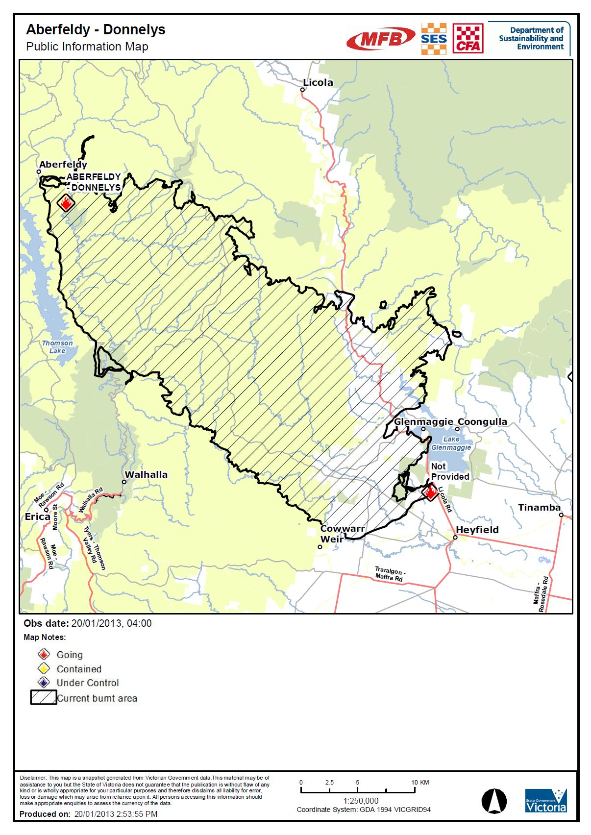
The main fire is the ABERFELDY – DONNELYS complex and it has already burnt more than 44,000 ha (as at 18 Jan). It started in the Aberfeldy area to the east of the Thomson Dam and Baw Baw plateau. It has now burnt east as far as the Licola road.

Check further down this page for updates on a fire that started Jan 21 in the north west spur area around Mt Feathertop.

UPDATE March 5:

VicRoads will open the Great Alpine Road to light traffic for the Labour Day long weekend, despite the ongoing maintenance and recovery works required after the Harrietville – Alpine North bushfires.

UPDATE, Feb 27: significant rain over the past day has greatly reduced fire activity across the Alps. The road from Heyfield to Licola has now been opened, as is the road from Omeo to Hotham Village.

The Great Alpine Road remains closed between Harrietville and Hotham and will remain so until further notice. Landslips on this road have added to the workload of removing ‘up to 10,000 fire killed trees’ along the GAR on this section.

Aberfeldy fire

UPDATE: Feb 15.

RECENT mild weather is helping suppression activities for the Aberfeldys-Donnellys fire and any more rain will ease conditions further.

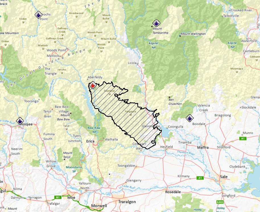
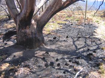
The Aberfeldy fire has burned through 84,100 hectares and has a perimeter of almost 400 kilometres. Firefighters have constructed control lines on more than 300 kilometres of that perimeter by hand, with machinery and from the air.

Today, there are 295 personnel working on the fire, supported by 11 tankers, 87 slip-on units (4WD vehicles), 14 dozers and seven aircraft.

Further control lines are being constructed near the junction of Hickeys Creek Track and the southern end of Mt Margaret Track to protect the Avon Wilderness.

Backburning operations in the area will continue when weather conditions allow.

UPDATE: Feb 11:

The CFA reports:

Country Fire Authority and DSE advise that there is fire activity and suppression works in the Licola, Glenfalloch, Wollangarra, Glencairn area.
  • This bushfire is being controlled.
  • There is backburning on private property west of the Macalister River between Glenfalloch and Licola. Residents of Licola and surrounds may see active fire and there will be considerable smoke.
  • This message applies to the town of Licola and areas of Glenfalloch, Wollangarra and Glencairn.
  • This fire has burnt through approximately 82,522 hectares.
  • Control lines are being constructed on the Mt Margaret Track in an attempt to halt the easterly spread of the fire.
  • Machinery continues to work along the public-private interface north of Licola and around Glencairn.
  • Melbourne Water and DSE crews are patrolling on the south end of South Rd, near Mt Useful where back burning operations have been undertaken.

UPDATE: late Jan 27

The Gippsland Times is reporting that:

THE public can access Walhalla and Licola after a number of roads closed due to the Aberfeldy-Donnelly Fire were re-opened.

The fire is continuing to burn but is being controlled.

As Saturday morning, an area of 69,823 hectares has been burnt with a fire perimeter approximately 416 kilometres in length with 220km of control line built.

About 438 personnel, 150 vehicles, 21 dozers and 14 aircraft are involved in fighting the fire.

Among the roads opened include Licola Rd and Walhalla Rd only to the Thompson Dam Access Road.

UPDATE: Jan 27: The CFA reports that:

This bushfire is being controlled.

The fire has now burnt 71,000 ha.

UPDATE: Jan 25: ABC is reporting that ‘Towns to the south of the Aberfeldy bushfire could soon be under threat with northerly winds expected to strengthen overnight’.

Authorities remain concerned that hot winds could cause the Aberfeldy-Donnellys bushfire to jump control lines this morning.

The fire has now burnt 67,000 ha.

1oAph

UPDATE: Jan 24. The CFA is reporting that the fire is being contained. Wind conditions have favoured crews working to build containment lines around the bushfire this morning, however, a predicted wind change is expected to challenge crews this afternoon.

The Alpine National Park and the Avon Wilderness Park are now officially closed.

UPDATE: Jan 23, 4pm. The Gippsland Times reports:

DSE and CFA crews have been working to consolidate containment lines ahead of a predicted wind change on Friday afternoon.

The Aberfeldy bushfire is now around 62,000 hectares in size and has destroyed 22 homes.

Deputy Incident Controller Adrian Gutsche said a change forecast for the wind change had delayed the risk “by 12 hours”.

Mr Gutsche said crews had been working to consolidate firebreaks and control lines to the south of the fire zone ahead of a predicted wind change on Friday.

UPDATE: Jan 23. The CFA reports that the fire has now burnt 63,233 ha. There will be ‘aerial ignition within control lines east of Walhalla occurring today’ and additional control lines on the Walhalla – Cowwarr road.

UPDATE: Jan 22. The CFA reports that ‘this bushfire is being controlled.
The Aberfeldy Road is closed north of Beardmore.
Burning out operations are continuing north east of Walhalla and east of Aberfeldy.
There was increased fire activity north of Walhalla overnight’

The Gippsland Times reports that:

About 600 crews, 130 vehicles and 13 aircraft are involved in fighting the fire, which is now 61,783 hectares in size with the fire perimeter now 322 kilometres.

Fire behaviour is expected to increase slightly as the temperature rises during the day and crews will continue backburning operations and building containment lines.

A critical 190 hectare backburn will reduce fuel loads in the unburnt area 5km south of Glenmaggie and 6km north-west of Heyfield. Smoke will be visible from surrounding communities.

UPDATE. Jan 21. The access to the mountains via Licola are still closed off. Restricted access has now been restored to Licola Rd, all the way from Licola to Heyfield.

Residents of the immediate area; people providing recovery and relief services, council or VicRoads employees or sub-contractors, and business owners in the immediate area can now access Licola.

Victoria Police has reiterated that many roads in the Seaton, Glenmaggie and Heyfield area are restricted to local access only.

Police will be actively patrolling the area and have asked drivers to take care on the roads and avoid unnecessary travel, particularly in fire-affected areas.

Department of Sustainability and Environment conducted a 180 hectare backburn Sunday morning in an unburnt area five kilometres south of Glenmaggie and 6km north-west of Heyfield.

This fire will remain active into Monday and possibly longer.

UPDATE. Jan 20. The Department of Sustainability and Environment advise that there is a planned 180 hectare back burn occuring in the Heyfield District area. The fire is still being contained. It has burnt 57,726 hectares.

UPDATE. As of Jan 19, the fire is still moving and has burnt out 52,669 ha.

The fire as at 19 Jan. Despite some claims from the usual (anti green) sources, the fire didn't start in a national park.
The fire as at 19 Jan. Despite some claims from the usual (anti green) sources, the fire didn’t start in a national park.

At this point (Jan 18) this is the only significant fire burning near the high country. There were media reports earlier in the day that this fire complex was heading for the Avon wilderness.

Wollangarra outdoor centre report that they have evacuated.

The CFA website has maps and regular updates. News reports say that the fire is ‘heading for the north east’ and into ‘forested areas’.

The following report comes from Cimara Pearce at The Weekly Times.

Licola residents trapped

australian_fires_scorched_earth_N2TEN Licola locals are trapped as an out-of-control bushfire heads towards the township.
Victorian Fire Services Commisioner Craig Lapsley confirmed 90 school children at a camp in Licola had been relocated to Traralgon safely but ten locals remained isolated in the town.

There are five fire crews with the residents battling the blaze which is expected to hit between 4pm and 6pm this afternoon.

The Licola Rd has been closed since this morning leaving remaining residents no way to leave.

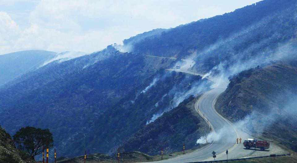
The blaze is now more than 44,500ha in size and creating spot fires 2-4km in front of it.

Mr Lapsley warned the fire, which still also threatens the townships of Seaton, Heyfield and Glenmaggie, could burn for as long as two weeks if mother nature was not kind.

“This has the potential to be a two-week fire fight,” he said.

“We would hope this weekend would be kind to us but there is no rain forecast.

“Without rain or moisture it’s very hard to bring it to a controlled position.”

He described the fire as difficult and unpredictable and said as the blaze spread into remote bushland it got harder to control from the ground.

There are more than 70 firetrucks, about 200 firefighters and 13 helicopters working to control the fire.

Five homes have already been destroyed in Seaton.

Heyfield incident controller Laurie Jeremiah told a media briefing at Seaton this morning that five homes were believed to have been burnt at Seaton and a family had been trapped in their house but were able to escape.

Mr Jeremiah also confirmed a fire tanker had been burnt.

The crew members took shelter in the vehicle while the fire went over and escaped unharmed, he said.

Mr Lapsley said the extent of damage to livestock and farm land was still unclear but would unfold in coming days and weeks.

“There will be damage to fencing and there will have to be damage to livestock,” he said.

“(Damage to livestock) is not something we have been able to calculate but there will be losses in those areas.”

north west spur area around Mt Feathertop

UPDATE. Feb 15. The Gippsland Times reports:

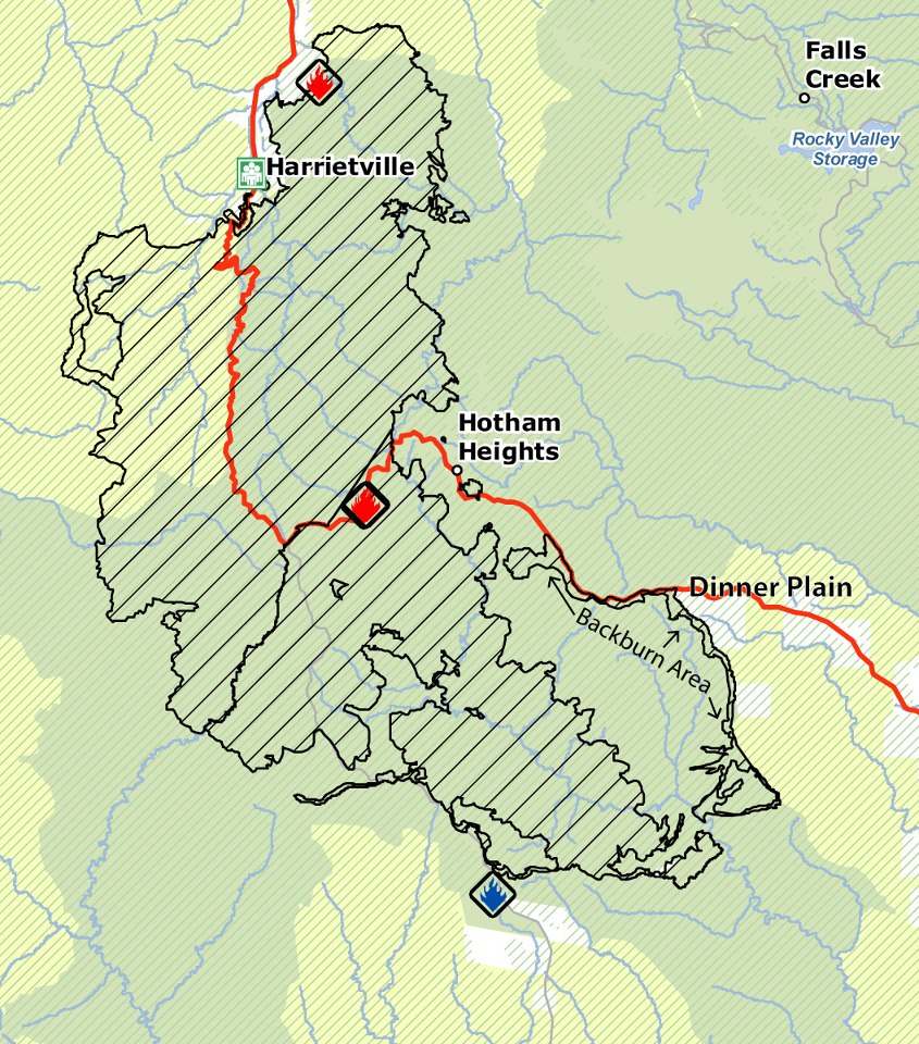
The Harrietville–Alpine South fire has not spread much overnight, but there will be increased smoke visible from communities today as backburning operations progress.

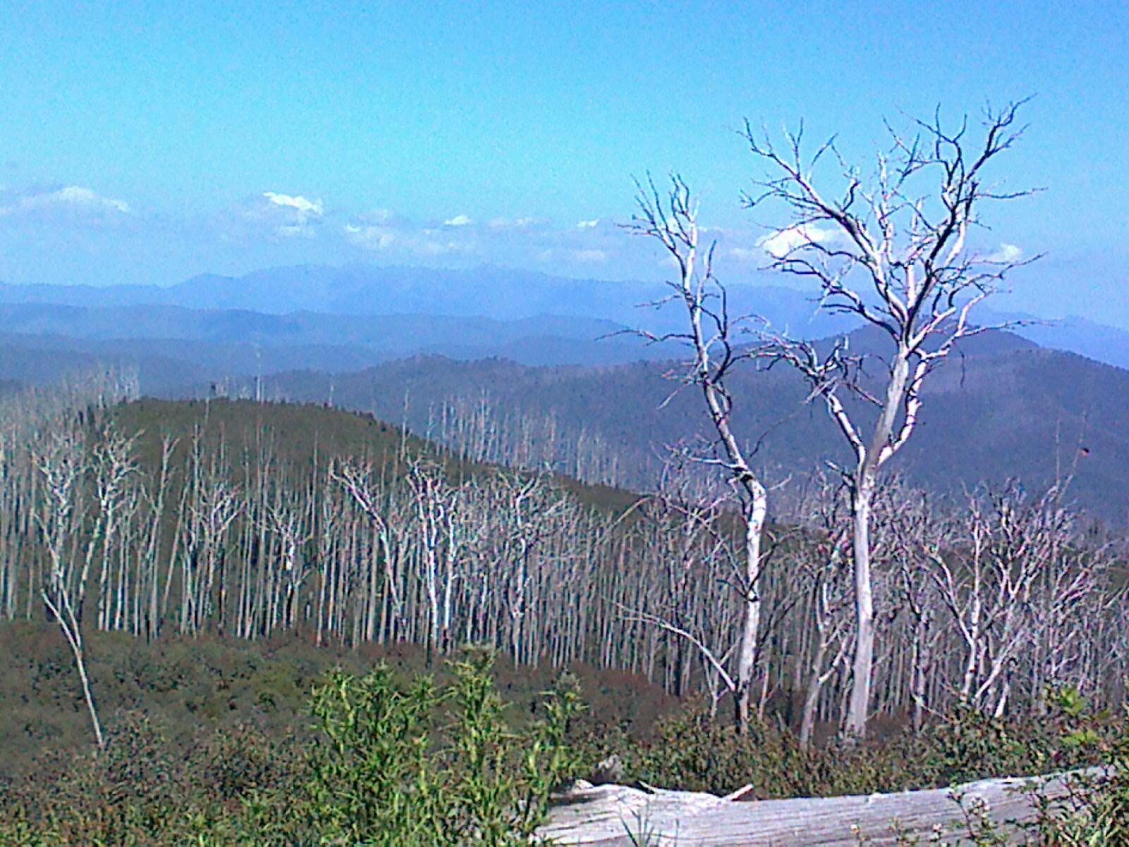
The fire is now 12,130 hectares, with a perimeter of 228 kilometres. 

The fire continues to burn in steep, rugged terrain with limited access for on-ground fire fighter crews.

 Ongoing asset protection, suppression and patrolling activities continue around Mt Hotham, Dinner Plain and Dargo.

Areas of sensitive natural values including cultural heritage places, threatened species and critical breeding habitat have been identified and protective works undertaken.

Combined, the north and south fires are 30,400ha.

The Great Alpine Rd has reopened to the public from Dinner Plain towards Omeo yesterday at 7pm. From Mt Hotham to Dinner Plain, access is restricted to residents, essential services, accredited media and individuals or groups delivering relief and aid to residents and to animals.

UPDATE: Feb 13. Backburning continues to protect Dinner Plain. The southern fire front is moving roughly south eastwards, to the south of Dinner Plain.

the southern fire, showing back burning lines around Dinner Plain, as at 12 Feb
the fire, showing recent back burning lines around Dinner Plain, as at 12 Feb

UPDATE: Feb 11.

From the Gippsland Times:

THE Harrietville-Alpine fire remains active in the Dargo River valley area north of Dargo, however moist and cooler weather conditions have resulted in a decrease in fire activity.

The Harrietville-Alpine South fire is about 7127 hectares, and is not yet under control. With the north and south areas combined, the Harrietville-Alpine fire is 23,411ha.

The focus of firefighters is on both asset protection and back burning to contain the fire.

Back burning work is likely to continue for at least the next week. Residents and visitors to the area are asked to take extra care when travelling on local roads, as they are likely to experience increased smoke across roads and in the community, increased firefighting activity, and a greater number of emergency vehicles travelling in the area.

Back burning operations began Sunday afternoon along the southern edge of the Great Alpine Rd from the Alpine Resorts Commission entrance between Dinner Plain and Mount Hotham Resorts down to Dinner Plain Track.

Road closures remain in place, and anyone intending on travelling in the area should check with VicRoads for any updates.

The Great Alpine Rd is closed between Harrietville and Dinner Plain.Dargo-High Plains Rd is closed between the Great Alpine Rd and Dargo until further notice. Access to forests and parks north of Dargo is restricted as a result of this closure.

The Alpine National Park is closed east of Harrietville extending along Westons Spur Track to the Australian Alps Walking Track to Pretty Valley Track, then south to the Great Alpine Rd to the boundary of the Alpine National Park and Dinner Plain State Forest.

Mount Feathertop and its approaches are closed.

State Forest north of the fire area including the West Kiewa is also closed.

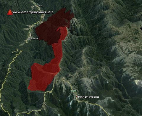
UPDATE. Feb 8. After a few days of continued fire control and mild conditions, fire activity has heightened considerably, putting Hotham village at direct risk. The fire is now operating on two main fronts. The fire was previously referred to as the ‘Harrietville – Feathertop Fire.’ It has been split into two fire sectors – the ‘Harrietville – Alpine North Fire’ and ‘Harrietville – Alpine South Fire’.

See below for update from Mt Hotham management:

The ‘Harrietville – Alpine Fires’ remains classified as ‘going’, no asset losses have been reported to date.

The wind direction has remained ‘NNW’ all day and with a wind speed of 30 kmh with gusts up to 50 kmh.  Humidity is low at 33%. 

Harrietville – Alpine South’ fire is firmly established in the ‘Dargo’ and has increased in size significantly during the course of the day.  The fire is visually prominent SW of the village, along ‘Morning Star Spur’ and below ‘St Bernard’ and is moving up toward Baldy Creek to the SW of the resort centre.   This fire activity is of concern – heavy aerial water bombing has been undertaken all day so as to prevent the fire moving into Baldy Hollow (immediately below the Village Centre and Summit).    One Erickson Skycrane and two bucket equipped heavy lift helicopters with have been refilling from the snowmaking dam at Loch every 7 minutes all day.  Dam capacity has been maintained.  CFA/DSE expect the ‘Alpine South Fire’ to make further SSE runs in the untracked forest of the ‘Dargo’ until at least late Sat/early Sunday given the predicted weather conditions.

The control strategies for this part of the fires are limited due the dense nature and ruggedness of the terrain.  The ‘Swift’s Creek’ ICC has indicated an ‘indirect attack/asset protection’ strategy aimed at keeping the main fire east of the ‘Dargo High Plains’ Road.

The ‘Harrietville – Alpine North’ fire continues to move through high elevation forest that was burnt in 2003 and 2006.  The fire has now burnt down to the ‘Diamantina River’ along a 500m stretch – which proposes a potential threat to the Resort Water Catchment.  Resort Management staff have observed smoke continuing to rise from the ‘Diamantina Area’, which indicates that the fire is still active, despite aerial suppression. CFA/DSE have reported that the hot edge on the Diamantina River continues to hold west of the river, but many hot spots remain, right down to the river bank. Felled timber on the helipad has delayed insertion of crews this morning, but crews are now working after the pad was aerial bombed. Options for providing water-pumping capability for ground crews to black out this edge are being explored

An aerial infrared scan (FLIR flight) this morning showed going fire continuing to back down in a westerly direction into the West Ovens and the upper part of the East Buckland catchments. The fire is also continuing to burn slowly down steep slopes into the headwaters of the Dargo catchment. It has reached the upper reaches of the Dargo River in some places and has uphill runs available to it once it crosses. The fire has burnt in a broad front southward along both sides of the Dargo High Plains Road. A further aerial FLIR scan will be flown this afternoon if time and conditions permit.

Note:  A ‘Watch & Act’ message for Hotham and Dinner plain remains in place and ‘Advice messages’ for Harrietville, Dargo, Cobungra, Omeo, Swifts Creek and Ensay.

Today, Saturday and Sunday are classified ‘high-risk’.

UPDATE. Feb 6. Backburning has been carried out south of Harrietville and along the Great Alpine Road on the south western side of Hotham summit in recent days.

CFA reports that:

  • This fire is yet to be contained
  • Fire activity has increased significantly this afternoon and increased smoke will be evident.
  • The fire has the potential to cross the Great Alpine Road approximately 12 kilometres south of Harrietville heading in a westerly direction.
Back burning along the Great Alpine Road near Mt Blowhard. Image: Dinner Plain Alpine Village facebook
Back burning along the Great Alpine Road near Baldy Hollow. Image: Dinner Plain Alpine Village facebook

UPDATE: Feb 3. The Harrietville-Feathertop fire has now burnt more than 6,100 hectares of the Alpine National Park.

Alpine National Park is closed east of Harrietville extending along Westons Spur Track to the Australian Alps Walking Track to Pretty Valley Track, then south to the

Great Alpine Road to the boundary of the Alpine National Park and Dinner Plain State Forest. Mount Feathertop and its approaches are still closed.

Backburning will be carried out to the south of Harrietville between Old Coach Road and the East Ovens River.

The Great Alpine Road is still closed between Harrietville and Dinner Plain.

UPDATE. Feb 1. Spot fires occured within Hotham Village and have all now been controlled. However, CFA reports that the main fire is still not yet under control.

  • This bushfire is approximately 5000 hectares in size and is out of control.
  • The Hotham Dinner Plain community meeting will be held at 3pm Saturday February 2 at Rundells Alpine Lodge Dinner Plain. 
  • The Great Alpine Road is closed between Harrietville and Dinner Plain and the Dargo High Plains Road is closed.
The Feathertop fire as of Jan 31

UPDATE. Jan 31. After a quiet few days, the fire is again threatening surrounding towns. The CFA reports:

There is a large, fast moving bushfire in the Mount Hotham and Hotham Heights area. It is travelling in a south– south westerly direction.
This fire is expected to impact anytime within the next hour. 
  • This bushfire is approximately 4100 hectares in size and is out of control, currently creating spot-fires approximately 2-3km/s ahead.
  • Relocation is not advisableIf required head to the neighborhood safer place.

UPDATE: Jan 28. The same as yesterday (see below). Additionally, the CFA advises that:

The Alpine National Park is closed east of Harrietville, west of Mt Cope, south of Mt Jim and north of the Great Alpine Road

UPDATE: Jan 27. The CFA reports that:

There is still fire activity near Harrietville township.
This fire is yet to be contained and considerable work will be occurring over coming weeks.
The Great Alpine Road and the Dargo High Plains Road are now open. Motorists are urged to use caution as emergency vehicles will be in the area.  

Hotham Heights is not listed as being at risk at present, the main focus is around Harrietville. The fire has burnt an area of around 3,000 ha.

UPDATE: Jan 25: ABC reports that ‘Strong northerly wind gusts of up to 90 kilometres per hour are fanning the flames of two bushfires burning in Victoria’s east.
The winds are expected to intensify a fire in the Alpine region near Harrietville and Hotham Heights‘.

A watch and act alert remains in place for both of those communities.

By 10am ABC was reporting that:

The weather bureau says strong winds will continue to affect a fire in Victoria’s alpine region, but the most severe gusts have peaked.

A watch and act alert remains in place for bot Hotham Hights and Harrietville.

And people at Dinner Plain are reporting:

Overnight there has been benign fire behaviour, with limited spread of fire since midnight.
A short section of fire has continued to back down to the control line around private property north of Harrietville, but has not caused control problems. The weather forecast indicates that Mt Hotham could be impacted by fire in the next 24hrs

UPDATE: Jan 24. The CFA report that the fire is still moving rapidly, and it is travelling in a south easterly direction.
This fire is expected to impact Hotham Heights, Harrietville anytime within the next 24 hours.

There is no evacuation order for Harrietville. Residents without fire plan are being advised to leave by 6pm today. A Watch and Act notice remains in place for the communities of Hotham Heights and Dinner Plain.

UPDATE. Jan 23, 3pm. The CFA advises:

This fire is expected to impact Falls Creek, Hotham Heights, Harrietville anytime within the next 24 hours.
  • The Great Alpine Road is closed between Harrietville and Hotham Heights.

UPDATE. Jan 23. The fire has continued overnight and the great alpine road is still closed, as are a number of parks in the area plus the Alpine National Park in the Feathertop vicinity. Check here for all closures.

Emergency services safely evacuated 37 hikers from the Mt Feathertop – Razorback walking tracks via helicopter.

The fire has burnt around 850 hectares in steep, dense bushland.

While no towns are directly under threat at this stage, fire services will closely monitor the fire and work hard to build containment lines today ahead of severe fire danger tomorrow.

UPDATE. Jan 22. 5pm. CFA are now advising:

This is a large, fast moving bushfire. It is travelling in a south easterly direction.
This fire is expected to impact Davenport Village, Falls Creek, Hotham Heights, Harrietville, Smoko anytime within the next 6 to 24 hours.
  • The great alpine road is closed between harrietville and Hotham Heights
  • Bushwalkers and other forest users are advised to avoid walking tracks in the Alpine National Park east of Harrrietville

It is described as being in the RAZORBACK NORTH WALKING TRK area, above the towns of Smoko, Freeburgh, and Harrietville.

Although described by the CFA as being ‘small’ the fire caused the Great Alpine Road to be closed on Jan 22.

A number of other small fires were reported on Jan 21 and 22 in the area, including one near Tawonga South and one near Falls Creek.

backcountry snowboarding magazine available in Australia

2516246Kronicle  is the world’s first backcountry snowboarding/ spiltboard magazine:

“Kronicle is a backcountry snowboard publication tailored to riders with a thirst for untracked snow, untapped lines, and exploration. We’re employing the richest stories, images and design to chronicle the people and places of backcountry snowboarding. That’s not all—we also report on the gear and skills riders need to reach their mountain objectives.

During its relatively short lifespan, snowboarding has covered a lot of ground and backcountry is the next frontier. It’s a homecoming of sorts, coming back to where it all began, bringing the sport full circle and leading us to Kronicle. This is our story, and it’s just the beginning”.

It is produced by Height of Land Publications in the US, who produce the excellent Backcounrtry magazine and, for many years, Telemark magazine. HOL produces high quality, visually gorgeous publications and Kronicle is a nice addition to their existing magazines.

Kronicle have teamed up with FirstLight Snowboards to provide this to the Australian Splitboard community.

You can order your copy from FirstLight here.

keep our Parks free of prospecting

 The following alert comes from the Victorian National Parks Association.

snow gums near Mt Lovick, VIC

Our national parks are under attack, yet again!

The Baillieu Government has asked the Victorian Environmental Assessment Council (VEAC) to make recommendations to introduce recreational prospecting into sections of up to nine national parks in eastern Victoria.

Importantly:

  •     VEAC cannot recommend that there should be no prospecting allowed in the parks, even if it reports that such activity would be harmful to the parks.
  •     VEAC has been given a very short time to gather evidence and make appropriate recommendations, indeed this will be the shortest ever VEAC investigation, and will largely take place over the holiday period.
  •     Prospecting with metal detectors can erode streamsides, harm rare plants and spread pathogens such as Phytophthora and Chitrid Fungus. But evidence-based information relating to both the impacts of fossicking and the complex geology of Victoria is not readily available. More time is definitely needed for this investigation.
  •     There will be no draft report, and only one period of public consultation.

Please write to VEAC, Victoria’s environment minister, and our energy and resources minister, saying:

  •     The terms of reference are flawed, because VEAC is forced to introduce fossicking to eastern Victorian parks, even if it decides the activity is harmful.
  •     There is no demonstrated high interest in fossicking in the eastern part of Victoria, even though vast areas of state forest are already available for that activity.
  •     There is absolutely no urgency for this investigation, so there is no need for such a tight timeline (and VEAC’s resources are already stretched, with two current investigations – Marine Parks and Yellingbo).

For more information, read the article Prospecting in Wonderland by Phil Ingamells in the latest edition of our magazine Park Watch.

For details of the investigation visit the VEAC website.

TAKE ACTION

Please, send a message now to Victoria’s environment minister, Ryan Smith, and the energy and resources minister Michael O’Brien saying that you are not happy with the restrictive terms of reference for this investigation, and that the timeline is far too short.

Please add your own concerns, and any of the information above.

Hon Michael O’Brien
Minister for Energy and Resources
Email: michael.o’brien@parliament.vic.gov.au

Hon Ryan Smith
Minster for the Environment and Climate Change
Email: ryan.smith@parliament.vic.gov.au

Senate Inquiry into extreme weather – an opportunity to share your experiences

Mt Stirling
Mt Stirling

The federal Greens have been successful in getting a Senate Inquiry into extreme weather. This is a significant opportunity for the government to consider the impacts of climate change and extreme weather events on local communities, landscapes and economies in the Alpine region.

It would be useful if you or your business or group were be able to make a brief submission to the inquiry about the threat of extreme weather and climate change in your community, and the impacts it has already had or is predicted to have. See below for some ideas on making a submission.

Time is short – we only have until January 18.

You may also want to make a formal request for the committee to visit your area and host a public hearing to take submissions from people who live in or are reliant on good winters to keep the local economy strong.

The snow industry – the canary in the cage when it comes to climate change?

The winter sports industry/community is deeply dependent upon predictable, heavy snowfall, but climate change is expected to contribute to warmer winters, reduced snowfall, and shorter snow seasons.

A recent US study, commissioned by Protect Our Winters (POW) and the Natural Resources Defense Council (NRDC), shows that the U.S. ski and snowmobile winter sports industry is currently worth an estimated $12.2 billion each year, and has already felt the direct impact of decreased winter snowpack and rising average winter temperatures.

As the authors note in the report, “climate change spells trouble for all businesses dependent on winter weather including snowboarding, snowshoeing and skiing. The shrinking numbers of winter sports tourists also affect restaurants, lodging, gas stations, grocery stores, bars” and other businesses.

Bogong High Plains fires, 2007

Here in Australia, winters are already becoming warmer and more erratic, and this impacts on the quality and quantity of snow.

According to Dr. David Bain, in the high Alps from 1950 to 2007 there has been an increase in winter temperatures approaching 1°C, and over much the same period (1957 to 2011), Australia has seen a slow decrease in snow depth. The mid-winter snow depths have only decreased a small amount, whereas spring snow depth has dropped by almost 40%. The obvious impact here is that the resort season becomes shorter, making it more difficult to make a profit on infrastructure that is located in resorts year round.

While resorts have invested in extra snow making capacity and are seeking to build visitation outside of the winter months, the majority of infrastructure is based around winter sports. Snow making will become more expensive in coming years as energy prices rise, and this will impact on resort profit margins and hence viability. As was highlighted in the 2012 document the Alpine Resorts Strategic Plan, “cost pressures are a major problem for many on-mountain businesses and site holders”.

Science suggests that without determined action to reduce climate change, we can expect to see less and less reliable snow falls in coming years.
According to the government commissioned report ‘Caring for our Australian Alps Catchments’, the Alps face an average temperature rise of between 0.6 and 2.9 degrees centigrade by 2050, depending on how much action the international community takes to combat climate change.

Rain, snow and other precipitation is expected to decrease up to 24% over the next four decades, accompanied by more bushfires, droughts, severe storms and rapid runoff, causing heavy erosion. Additionally, what precipitation we get could become more erratic. For instance, it is likely there will be more storm events in summer, which could be expected to impact on outdoor recreation and especially organised events like bike rides and festivals. The 2003 and 2006/2007 fires in Alpine regions are an indicator of what could come with enhanced global warming. These shut down tourism across sections of eastern Victoria, with dramatic impacts on businesses reliant on summer tourism.

The Caring for our Australian Alps Catchments report says that our ski slopes could be completely bare of natural winter snow by 2050 unless concerted action is taken against global warming.

The erratic weather will also be felt in winter, with corresponding impacts on economies. The US report notes that in that country, the downhill ski resort industry is estimated to have lost $1.07 billion in aggregated revenue between low and high snow fall years over the last decade: if the snow is bad, many people will simply cancel their holiday. So even if there is some snow cover, erratic weather can still have impacts.

All of this will be a disaster for skiers, boarders and all who spend their time in the Alps.

Buffalo Plateau from Big Hill

But it will also be devastating for local economies. In Victoria, the alpine resorts are estimated to have contributed $570 million and 5,800 Full-Time Equivalent jobs to the Victorian economy in winter alone for 2011 (source: Alpine Resorts Strategic Plan 2012, p13). The flow on effects of the industry is felt in towns throughout north east Victoria and around the Snowy Mountains, including the development of niche agriculture economies which is, in part, supported by snow-based tourism. To take one example of local benefits, the ‘gross regional profit’ of Alpine Shire was increased by about $130 million in 2011 because of the presence of the alpine resorts. The negative impacts of the bushfires on Murrindindi Shire in this same period indicate what climate change and extreme weather events could mean in future for all shires across the state.

According to the Economic Significance of the Australian Alpine Resorts report (2011), the combined benefit for the three Australian States with alpine resorts in 2005 is calculated to be $1.3 billion with 17,050 annual equivalent employment opportunities.

As the US report concludes: “all of this translates into less snow and fewer people on the slopes, which results in massive economic hardship for resorts, states, local communities, businesses and their employees.”
Please write a submission

In order to protect the alpine environments that we love and the many thousands of people and businesses who depend on a snow-filled season, we must act now to support policies that protect our climate, and in turn, our slopes.

You can read more about the Inquiry and make a submission here.

Some points you may like to make:

Apart from any direct impacts you are concerned about, you might want to mention that the latest science is showing that the impacts of climate change are happening faster than expected, and that communities will require funding to deal with the worst predicted outcomes. There must be greater community engagement about adaptation to climate change. However, responding to climate change (‘adaptation’) is not enough: we must also respond to the causes of climate change – by reducing emissions (‘mitigation’).

Check here for climate change scenarios for the Alps.

If you would like the Senate Inquiry to visit your town to hear your concerns about climate change and extreme weather, please check here.

Submissions are due on 18 January with the final report due from the Senate Committee on 20th March.

Mt Sugarloaf and The Gunns

The Gunns from The Twins (Buffalo plateau in background)

Leading up from the plains of north eastern Victoria, there are many hundreds of ridges that snake up to the Great Divide. It is the higher, alpine ranges that get most of the attention from walkers. Yet there are some great walking opportunities in the mid level ranges, although you will often have to share the trail with 4WDs and trail bikes.

One obvious trip in the Mount Hotham area is Mt Sugarloaf and the highpoint of The Gunns. This is the highest section of a range that starts just near Bright and climbs through Mt Ebenezer and gradually towards the Divide, reaching its highest point at Mt St Bernard.

Check here for track notes.

Public ski resort groomed for private sale

The following comes from the Victorian National Parks Association.

Media release. Thursday, 28 November, 2012

art-Lake-Mountain-Village-420x0Lake Mountain, Melbourne’s closest and most affordable alpine resort, will soon be given over to developers in a long‐term lease that effectively privatises public land.

“The Baillieu Government should not be acting like a real estate agent for land that belongs to all Victorians. It should be managing our natural heritage responsibly, for future generations,” the Victorian National Parks Association’s Phil Ingamells said today.

“The Baillieu Government’s announcement that it is handing over management of the Lake Mountain Alpine Resort to a private recreation company, in preparation for auctioning the leasehold, may be the first of many such developments. Our alpine resorts, national parks and other public land are all vulnerable to this policy,” he said.

Importantly the Alpine Resorts Act, which governs the management of Victoria’s alpine resorts, makes it clear that resorts are for the use of all sections of the community, not just the big spenders.

A recent State Services Authority inquiry into Victoria’s alpine resort management said the resorts need to provide for a far greater section of the community, not just high‐end tourism.

The inquiry also recommended that resorts such as Lake Mountain, which will be the first to lose their snow cover as global warming increases, should be placed under the management of Parks Victoria.

“But the Baillieu Government seems determined to hand our finest bits of public land over to private control, and make them playgrounds for the wealthy,” said Mr Ingamells.

“Developments in private hands inevitably grow. This is a short‐sighted move, and one that will be very hard to reverse. Victorians of the future will almost certainly look back at this time with great regret.”

Alpine Resorts Strategic Plan 2012 finally tabled in Parliament

The following comes from the Minister for Environment and Climate Change, so should be read essentially as propaganda.

I would be interested in any industry/ community/ environmental perspectives on the new plan.

From the Minister for Environment and Climate Change

Image: Brush Ski Club

The long-term viability of Victoria’s alpine resorts will be strengthened following the tabling in Parliament today of a new strategic plan by Minister for Environment and Climate Change Ryan Smith.

The Alpine Resorts Strategic Plan 2012 will shape the long-term direction of Victoria’s six alpine resorts of Mt Hotham, Falls Creek, Mt Buller, Mt Stirling, Mt Baw Baw and Lake Mountain, ensuring they remain attractive tourist destinations, financially viable and capable of attracting new investment.

Mr Smith said the strategic plan recognised the fact that the winter season was the economic engine of the resorts, however opportunities existed to expand their array of iconic non-winter events and investment opportunities.

Under the strategic plan, each of the resorts will prepare an alpine resort master plan ensuring their environmental values are protected and providing the commercial sector greater certainty about the resorts’ long-term directions.

“The Alpine Resorts Strategic Plan 2012 outlines a vision for the resorts and a plan of actions to ensure they are vibrant, growing and financially sustainable places well into the future and their environmental values are preserved,” Mr Smith said.

“The strategic plan sets out a more co-operative and integrated approach to investment, promotion, management and use across the resorts.

“The plan focuses on paying more attention to the long-term financial viability of the alpine resorts, focusing on the winter economic ‘engine’ and building on the year-round competitive strengths of individual resorts.

“Victoria’s alpine resorts make a significant contribution to the State economy, especially in regional Victoria and the Coalition Government is committed to ensuring they remain viable into the future.”

In 2011 the resorts were visited by more than 1.2 million people, contributed $570 million to Gross State Product and generated around 5,800 full-time equivalent jobs for winter alone.

Mr Smith said the alpine resort master plans would simplify planning and leasing decisions and allow high priority development opportunities to be identified through the Victorian Alpine Resorts Development Program.

“We need to make sure that resort services and infrastructure are delivered efficiently and with appropriate levels of accountability.

Investment opportunities need to be more co-ordinated and non-commercial activities will need to be reviewed,” Mr Smith said.

The strategic plan proposes a new financial management framework for the alpine resorts to sustain their significant economic contribution to the State’s economy and to their surrounding regions.

The strategic plan also outlines actions to build partnerships across sectors and increase access for Victorians of all backgrounds.

“Victorian alpine resorts are on public land and are managed on behalf of all Victorians, so it is important we ensure alpine experiences are accessible to people of differing cultural backgrounds, ability levels and economic circumstances,” Mr Smith said.

“Major initiatives include a focus on growing visitation by enhancing the visitor experience and further development of the resorts. This means maximising benefits from winter visitation, non-winter or “green season” visitation and more integrated marketing,” Mr Smith said.

Activities such as horse riding, bush walking, road and mountain bike riding, fishing, festivals and events and even high-altitude training are set to become a non-winter feature under the new strategic plan.

The Alpine Resorts Strategic Plan 2102 includes opportunities to improve the regulatory environment and initiatives to address impediments to economic opportunities in the resorts, including:
·    planning and leasing arrangements;
·    native vegetation offsets; and
·    bushfire and emergency management.

The Alpine Resorts (Management) Act 1997 requires the Alpine Resorts Coordinating Council to conduct a five-yearly review of its strategic plan.

Extensive public consultation was conducted as part of the development of the Alpine Resorts Strategic Plan. A total of 250 people participated in workshops in Melbourne and at the resorts, and 66 submissions were received which were considered during development of the strategy.

More information about the Alpine Resorts Strategic Plan 2012 is at http://www.dse.vic.gov.au

Snow gone? US ski resorts see melting future

Mountain Journal has previously covered some of the initiatives of US ski resorts attempting to become more sustainable and also respond to the threats of climate change.

This recent summary of the situation there mirrors whats happening in Australia – with resorts struggling with poor natural snow, attempting to provide cover through snow making, and re-braninding themselves as year round resorts.

This article comes from the Sydney Morning Herald.

Skier in Colorado, USA

Helena Williams had a great day of skiing at New Hampshire’s Mount Sunapee shortly after the resort opened at the end of November, but when she came back the next day, the temperatures had warmed and turned patches of the trails from white to brown.

“It’s worrisome for the start of the season,” said Williams, 18, a member of the ski team at nearby Colby-Sawyer College. “The winter is obviously having issues deciding whether it wants to be cold or warm.”

Her angst is well founded. Memories linger of last winter, when meager snowfall and unseasonably warm temperatures kept many skiers off the slopes. It was the fourth-warmest winter on record since 1896, forcing half the nation’s ski areas to open late and almost half to close early.

Whether this particular winter turns out to be warm or cold, scientists say that climate change means the long-term outlook for skiers everywhere is bleak.

The threat of global warming hangs over almost every US resort, from Sugarloaf in Maine to Squaw Valley in California. As temperatures rise, analysts predict that scores of the nation’s ski centers, especially those at lower elevations and latitudes, will eventually vanish.

Under certain warming scenarios, more than half of the 103 ski resorts in the Northeast will not be able to maintain a season length of 100 days by 2039, according to a study to be published next year by Daniel Scott, director of the Interdisciplinary Center on Climate Change at the University of Waterloo in Ontario.

By then, no ski area in Connecticut or Massachusetts is likely to be economically viable, Scott said. Only 7 of 18 resorts in New Hampshire and 8 of 14 in Maine will be. New York’s 36 ski areas, most of them in the western part of the state, will have shrunk to nine.

Rockies

In the Rockies, where early conditions have also been spotty, average winter temperatures are expected to rise as much as 7 degrees by the end of the century. Park City, Utah, could lose all of its snowpack by then. In Aspen, Colo., the snowpack could be confined to the top quarter of the mountain. So far this season, several ski resorts in Colorado have been forced to push back their opening dates.

“We need another six or eight inches to get open,” said Ross Terry, the assistant general manager of Sunlight Mountain, near Aspen, which has pushed back its opening day to Friday from Dec. 7.

The warming trend “spells economic devastation for a winter sports industry deeply dependent upon predictable, heavy snowfall,” said another report, released last week by the Natural Resources Defense Council (NRDC) and Protect Our Winters, an organisation founded to spur action against climate change.

Between 2000 and 2010, the report said, the $10.7 billion ski and snowboarding industry, with centers in 38 states and which employs 187,000 people directly or indirectly, lost $1.07 billion in revenue when comparing each state’s best snowfall years with its worst snowfall years.

Even in the face of such dire long-range predictions, many in the industry remain optimistic. Karl Stone, the marketing director for Ski New Hampshire (a trade group), said good winters tended to come after bad ones — the winter of 2010-11 was one of the snowiest in recent memory — and that a blizzard could erase a warm spell. The basic dynamic he lives with is unpredictability; some areas that were warm last week have snow this week and vice versa.

“Things can change quickly, thanks to one storm, and that’s usually how it works this time of year,” he said, noting the current on-again, off-again snow pattern.

On a warm day last week, when the thermometer reached 51, Bruce McCloy, director of marketing and sales here at Mount Sunapee, was generally upbeat about the coming season, but he could not ignore the brown slopes outside his office window.

“The real problem with a day like this is that you can’t make more snow,” he said. “There are only so many days until Christmas, and we need so many days at certain temperatures to get the whole mountain done.”

Even in the Rockies, it is difficult to find enough water to make snow. After last year’s dry winter and a parched, sweltering summer, reservoirs are depleted, streams are low, and snowpack levels stand at 41 percent of their historical average.

September view

At Sunlight in Colorado, the creek that supplies the pond that, in turn, provides water for snow guns has slowed to a near-trickle.

“It’s a nice day — for September,” said Greg Ralph, the marketing director at Monarch Mountain, which depends exclusively on natural snow. Monarch was scheduled to open the day before Thanksgiving but has pushed back that date to Friday.

Ralph estimated that 250 employees at Monarch have been “on hold” as the resort languished in the unseasonable warmth.

Concerns about global warming are intensifying at a time when the industry has seen little growth. While ski seasons have swung between epic and terrible over the last 30 years, the number of ski visits nationally from 1979, when the industry started keeping records, to 2011 has grown at a compounded annual rate of only 0.6 percent. Counting 2012 would put the growth rate closer to zero.

The chief reasons, according to people in the industry, are the aging of baby boomers, long skiing’s most active enthusiasts, and the fierce competition for time, whether from Caribbean cruises or computers.

Add something called “backyard syndrome,” in which urbanites who live in easy driving range of a ski resort — say, Bostonians, who live 90 minutes from Sunapee — are reluctant to head north unless they see snow at home. Even when live webcams show a resort blanketed in white, McCloy said, it is hard to move urbanites to the mountains “until they’re shoveling snow or they’re stuck in it.”

In response to these problems, ski areas have developed adaptation strategies to lure people to their resorts even if the skiing is marginal. Many have expanded into four-season destinations and offer an array of activities that do not depend on the weather: concerts, yoga, craft fairs, conferences, water parks and spas. Sunapee opened a new adventure park this summer with canopy ziplines, a treetop obstacle course and golf.

Snowmaking

The most basic strategy for coping with a lack of snow is to make it, and as of the 2009-10 season, 88 percent of resorts belonging to the National Ski Areas Association were doing so. Dramatic improvements in snow-making technology have helped resorts compensate for warming trends, and several have invested millions in new energy-efficient tower guns.

“So far, the technology has kept up with climate change,” said McCloy at Sunapee, one of those resorts that Scott in Canada predicted would be put out of business eventually by global warming. “In fact,” McCloy said, “it’s probably improving faster than climate change is happening.”

That may not be the case for long. “With nighttime minimum temperatures warming at a faster rate than daytime maximum temperatures,” the NRDC report said, “it is uncertain as to what extent snow-making will last as an adaptation strategy.”

Article originally from the NYT.

Girl rescued after 5m hiking fall


Cross Cut Saw

The following report comes from The Weekly Times, journalist:  Sarah Scopelianos |  November 26, 2012

A 15-YEAR-OLD schoolgirl was flown to hospital today after sliding off a hiking track in the Baw Baw National Park while with a school group.

The girl was part of a group of nine students and teachers who were hiking between Mt Buggery and Mt Hewitt (sic) when the accident happened.

The girl slid about 5m down a rock face and landed on a ledge.

An Ambulance Victoria spokesman said a paramedic was lowered on to the ledge from the Air Ambulance to stabilise the girl and then the pair were winched to safety.

The service was called at 10.09am to Wabonga, near Mansfield.

He said the girl had neck and back complaints and cuts.

She was flown to the Latrobe Regional Hospital in a stable condition.

review: A Night on a Mountain in Namadgi National Park

Whenever I fly from Melbourne to Canberra I try and get a window seat facing south, to get whatever glimpses I can of the High Country. The descent takes you over the wonderfully rocky, domed ridges of the Brindabella Ranges, scattered with frost hollows and ratty looking snow gum fringed ridgelines.

I haven’t been up into those mountains for years, but it’s on my perennial ‘to go’ list. Coming from the south I find the Main Range of the Snowies is normally sufficiently distracting that I don’t get any further north.

In the modern world of evolving media, the concept of ebooks has become popular. These can be books on specialised themes made by regular people, which are available in a print per purchase format, allowing an idea for a book to make it onto paper without the costs and commitment of producing a large print run.

A Night on a Mountain in Namadgi National Park is produced by Barrie Ridgway and available via Blurb, one of the online book companies. When you order it, a copy is printed and mailed.

The author says “this book is a textual and photographic portrayal of the beauty, vastness, peace and preciousness of wilderness in general and a unique Australian wilderness in particular. It is my portrayal of the need to preserve wilderness in its own right for the survival of all life on this planet Earth”.

It is a set of visually gorgeous photos taken as the author and his friends climb a peak in Namadgi Park to watch the sun set and spend the evening on the mountain. It reminds me of the ‘mountain viewing rituals’ described by deep ecological thinker Dolores laChapelle.

The book is primarily full colour photos, with some minimal commentary about the journey up the mountain and a plea to protect wilderness. It is a worthy addition to our literature about the Australian Alps, largely letting the landscape speak for itself, albeit through the eyes (lens) of someone with a great affinity for the place.

You can buy it via the Blurb website. Although this is expensive, it is a glorious book of 98 pp, with lots of gorgeous full colour pics at all scales, from the micro to the landscape level. The Softcover version comes in at about $50.

Flow mountain bike magazine

Outdoor magazines can get a bit obsessed with gear and new stuff. All the latest bikes, skis, boards, clothing. Flow magazine is a new, home grown entry to the rather crowded mountain bike scene, and its refreshing because it focuses on the people that are riding, without getting too obsessed with the latest carbon fibre frames.

Issue one is on sale now and has a feature on ‘why we ride’, with a series of reports on road trips and non pretentious profiles on ‘average’ MTB riders and clubs. I love the one about a truckie from Albury.

Chris Southwood and Mick Ross from Sydney are the co-founders of Flow Mountain Bike. It’s clear they are riders themselves and bring a lot of their passion for their sport to the magazine. And while it has some great photos from overseas, it has its sights set on Australia and what our terrain has to offer riders.

There is a great photo essay on riding in the Blue Mountains and beyond that evokes that shimmering heat of summer, a few test articles, coverage across the sport from the World Cup circuit to weekend warriors, plus some good columns from different riders. It’s a bit bloke heavy, but that may broaden out over time.

Chris and Mick say “Flow Mountain Bike exists to inspire; through our words, images and videos we want mountain bikers to find the inspiration to ride more, try something new, travel somewhere fresh, or make mountain biking more central to their life”.

They save the technical stuff largely for their website, which aims to be the “leading online resource for Australasian mountain bikers of all disciplines”.

While the website is useful, I have to agree with Chris and Mick: “nothing can replace the engaging experience of a good magazine”.

I also love the name. ‘Flow’ is the place you go to when your turns are working, or the swell is just right, or the track is perfect. It doesn’t matter if it’s riding, boarding, surfing or climbing, there is a wonderful space you slip into when you’ve hit your stride in your sport, and your gear, technique and skill, and the conditions bring it all together. It seems like this magazine is homage to that moment in riding when you’re truly in the flow. A magazine is a good thing, getting out there is really what it’s all about.

Check it out, and support it if you can.  It has a nice clean design and some great images. Available widely in newsagents or via subscription.

Backcountry journal – Spring Mission to Feathertop

Scoping the line, image: Sam Leitch

Recent warm weather has really burnt off much of the snowpack remaining in the Victorian Alps, especially on lower elevation and north facing slopes. But there are still some great slopes and gullies, especially those facing south and east.

The following trip report by Sam Leitch comes from Mountain Watch, and features some great images of spring conditions on Mt Feathertop’s impressive east face.

Anyone who has skied/ boarded this terrain will know Hellfire and Avalanche gullies, this is serious country which can be dangerous because of cornice collapse, slide avalanches, and ice, even occasional rockfall. Being east facing it can quickly become extremely icy once in the shadows. Graeme Nelson, a highly experienced skier died here in the winter of 2011.

With spring in full swing and plenty of snow, conditions were great, but as Mike Garrett found on his trip to the Blue Rag Range, things don’t always go according to plan.

Read Sam’s report here.

Blog at WordPress.com.

Up ↑