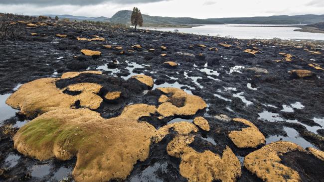
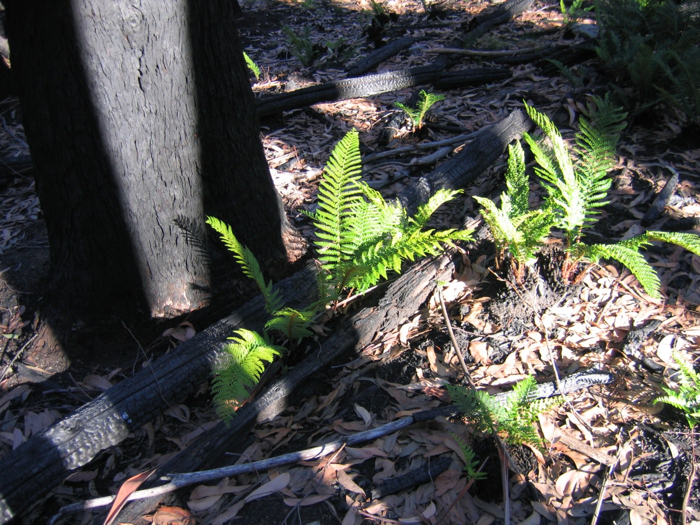
Last summer saw some of the worst bushfires in Tasmania for decades. Fire services were overwhelmed and large areas of the World Heritage Area were badly burnt before authorities were able to bring the fires under control.
Fires impacted about 20,100 hectares, or 1.3 per cent, of the Tasmanian Wilderness World Heritage Area. The worst hit areas included Lake Mackenzie (13,822 hectares), Gordon River Road (3,520 hectares) and Maxwell River South (1,389 hectares).
In a significant move, volunteers with the Country Fire Authority (CFA) in north east Victoria have called for a halt to planned fuel reduction burns in the Strathbogie Ranges. Mountain Journal has previously reported on community calls to halt the burns because of the likely ecological impacts.
In a good development on the Tasmanian fires, the Senate has formally called on the Federal Government to establish an independent inquiry into the recent fires in Tasmania’s World Heritage Area.
A motion moved by Greens Senator Nick McKim and Labor Senator Lisa Singh passed the Senate on Monday afternoon.
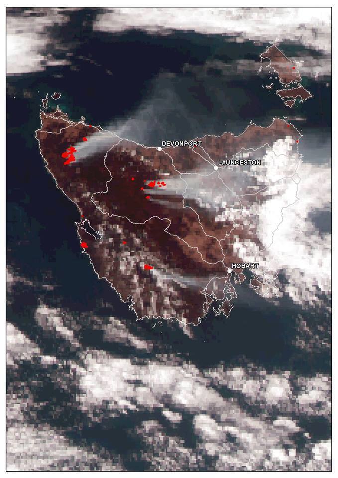
Lightning strikes lit well over 100 fires across Tasmania in mid January. As of Feb 3, more than 50 are still burning, and there have been significant impacts on townships, especially in the north west and north of the state.
Check here for details on the status of the fires, why they are so destructive, and whether there are links to climate change.
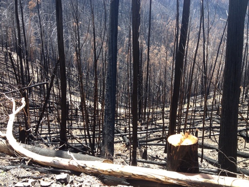
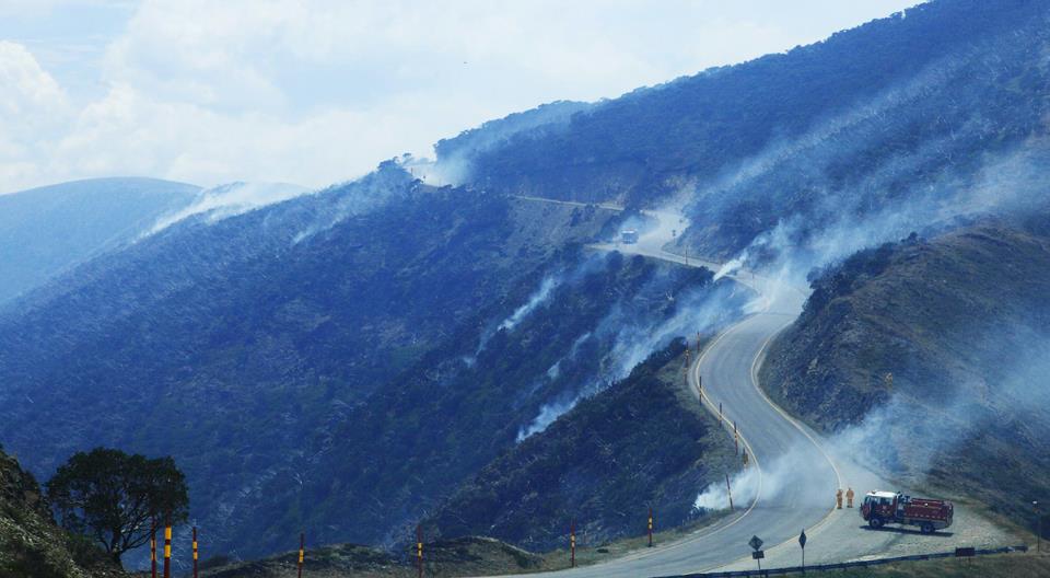
Lightning storms earlier this week started a number of fires in the high country, including one in the Buckland valley, Tawonga South, and on the Old Coach road between Mt Hotham and Harrietville. Parts of this area has been burnt three times in a little more than 10 years, with huge impacts on the alpine ash forests of the upper Ovens Valley and surrounding watersheds.
The Victorian government has announced changes to how fuel reduction burns (‘controlled burning’) will be carried out in the state.
Since the Black Saturday fires of 2009, public land managers have been seeking to burn 5% of public land each year. This has been criticised for being a very blunt management instrument for a complex problem. There are concerns that burning regimes have been inappropriate for some types of vegetation, causing ecological damage, and have not been able to reduce overall fire risk in the state.
Fuel reduction (also called controlled burning) is a key tool used by land managers to reduce the intensity of fires when they do occur. Its a simple theory: do a controlled, ‘cool’ burn through an area to reduce the amount of fuel on the forest floor.
In Victoria, there is an annual target, whereby public authorities need to try and burn 5% of public land each year. This has lead to widespread criticism that Parks are burning areas a long way from ‘assets’ (house, farms, etc). In effect, it seems that the target has become political rather than about reducing fire risk. There is also evidence that some fire regimes being imposed on some landscapes may be causing ecological harm or even potentially increasing fuel loads through changing vegetation structure.
People who visit the Australian high country know how badly it has been impacted by bushfires over the past decade.
In Victoria, we experienced the Eastern Alps fire of 2003, which burnt 1.3 million hectares, and also in 2006/07 which burnt almost 1.3 million hectares. Then over the summer of 2012/13, theAberfeldy-Donnellys Creek and Harrietville fires also burnt large areas of the mountains. Some sections have been burnt three times in a decade, with loss of significant stands of Alpine Ash and snow gums.
I have often wondered what the fire impact might mean in terms of snow cover. Obviously where there is the classic open canopy of a mature snow gum woodland, at least half the ground is at least partially shaded from direct sunlight. Often snow will stay in better condition under the trees when its getting sun affected in the open areas. And equally you will often get snow lingering in the forests once it is mostly burnt off in adjacent treeless areas.
Victoria’s forest firefighters who are employed by the Department of Environment, Land, Water & Planning (DELWP) are fighting for fair pay and recognition as genuine emergency services workers.
The following information comes from the Australian Workers Union.
Approximately 95% of the bushfires that occur across Victoria take place on public land, where forest firefighters are the first to respond. Apart from responding to many of these fires, DELWP firefighters are also expected to perform a range of highly skilled duties in public assistance areas such as missing person searches, pest control, biosecurity incursions, marine pollution management, flood and heatwave, mine rescues and disruption to water or energy supplies.
So far, the fire season has not seen any large fires in the high country. Let’s hope it stays that way! There has been one small one on the Bogong High Plains and the Mt Selwyn area. Dry lightening strikes have been problematic on a number of occasions.
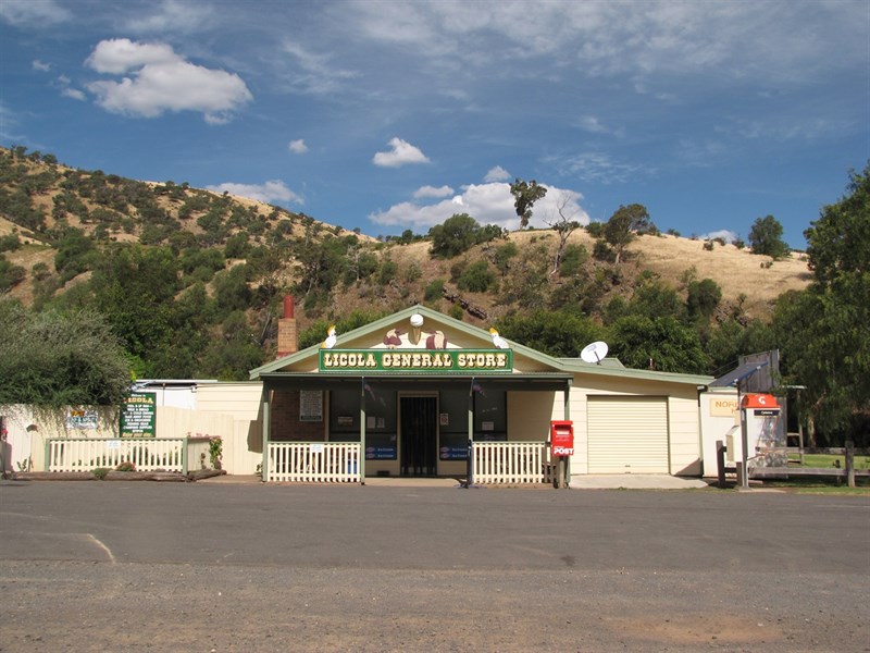
Department of Environment, Land, Water and Planning fire crews are responding to two fires about three to five kilometres north-east of Licola and a small fire the Alpine National Park about 28km north-west of Dargo.
As of Thursday morning, the fires were each about 0.5 hectares in size.
DELWP fire crews also responding to There was no threat to communities.
Smoke may be visible from nearby communities and roads.
You can find details on current fires via the CFA website.
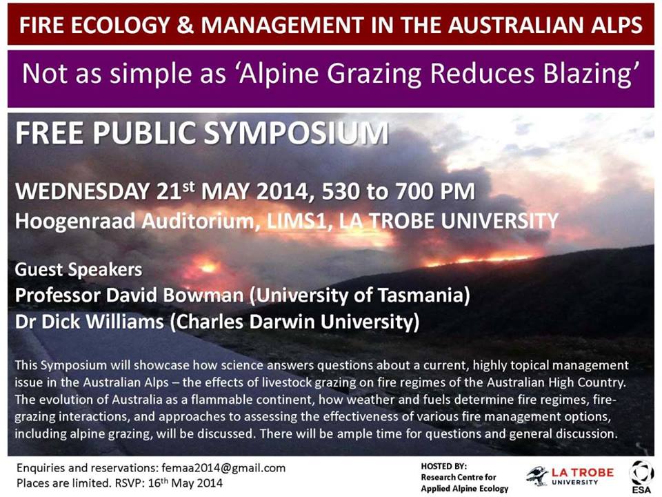
Hoogenraad Auditorium, La Trobe Institute for Molecular Sciences
LA TROBE UNIVERSITY, Bundoora Campus
Hosted by the Research Centre for Applied Alpine Ecology, La Trobe University
This Symposium will showcase how science answers questions about a current, highly topical management issue in the Australian Alps – the effects of livestock grazing on fire regimes of the Australian High Country. The guest speakers will address globally important topics such as the evolution of Australia as a flammable continent, how weather and fuels determine fire regimes, fire-grazing interactions, and approaches to assessing the effectiveness of various fire management options, including alpine grazing. This is a public forum about an important land management issue, and there will be ample time for questions and discussion at the conclusion of the talks. The Symposium will be followed by drinks and nibbles.
This Symposium is a must for anyone with an interest in the ecology and management of the Australian Alps. Enquiries and reservations: femaa2014@gmail.com
There is no doubt that our fire seasons are getting longer and more intense. Here in the south east, in terms of massive fires (greater than 250,000 ha), Victoria experienced two such events in the 19th century and five in the 20th century. In less than two decades, we have already had three mega fires in the 21st century. Many alpine areas have been burnt three times in the space of a decade.
There is no coherent overall response as yet by state or federal governments that outlines how we should respond to the growing interaction of climate change and wildfire. Sadly, our Prime Minister is in denial, having claimed that since ‘fires have always been part of our landscape’ there is no link to climate change. The Victorian state government has been challenged on the lack of attention to climate change in it’s approach to managing fire risk. Reducing fire risk is therefore about reducing fuel load and getting larger equipment , not about reducing greenhouse gas emissions or accepting that enhanced fire risk is the new reality for much of the country.
The following report, from Grist, outlines a different approach. The US government has released a strategy that aims to respond to the changing nature of fire threats. One aspect that especially interested me is the fact that it includes an approach that aims to ‘restore and maintain landscapes that are resilient to fire.’ In Victoria, we seem to be doing the opposite. There is a politically driven target that dictates that 5% of the state will receive fuel reduction treatment each year. This is in spite of the fact that some vegetation types don’t need burning to maintain ecological health, and others can become more flammable with the wrong fuel reduction approaches, and others are directly threatened by too much fire.
Climate change just reshaped America’s wildfire strategy
Like a tree in a greenhouse, America’s forest fire problem is growing ominously. Rising temperatures and declining rain and snowfall are parching fire-prone areas and juicing conflagrations. On Thursday, following years of meetings and scientific reviews, the Obama administration published a 101-page strategy that aims to help meet the country’s shifting fire threats.
The National Cohesive Wildland Fire Management Strategy divides the nation according to fire risks, and profiles the communities that face those risks. “No one-size-fits-all approach exists to address the challenges facing the Nation,” the strategy states.
Despite covering 70,000 communities and 46 million homes, the strategy can be boiled down to guidelines that aim to do three main things: restore and maintain landscapes that are resilient to fire; brace communities and infrastructure for occasional blazes; and help officials make wise decisions about how and whether flames should be doused. Here’s what that all looks like in flowchart form:
“As climate change spurs extended droughts and longer fire seasons, this collaborative wildfire blueprint will help us restore forests and rangelands to make communities less vulnerable,” said Mike Boots, chair of the White House Council on Environmental Quality.


Recent Comments