Recently I was enjoying an evening hanging out at Bluff Spur hut on Mt Stirling. The 9 folks there had long and interesting yarns and, as is usual in a backcountry hut, many of the chats often focused on the adventures we have enjoyed in the mountains.
A common theme was favourite places, and favourite people and at some point Bill Barker, head of ski patrol at Mt Hotham, came up and we agreed he was a living legend. We discussed our favourite huts (King Saddle, Cleve Cole and Vallejo Ganter), favourite mountains (Feathertop, Bogong), and favourite camping spots (well that would have to be a secret).
I got an idea for Mountain Journal magazine #4. What are the icons of the mountains we love? What people, what places, what forests, what institutions? I am hoping you will feel inspired to write a brief piece on your favourite mountain icon, for publishing on the website and (later on) in the next edition of the magazine.
An Icon is
‘A person or thing widely admired especially for having great influence or significance in a particular sphere’.
It might be a person who inspires you, a place, a mountain hut, a river, a business or other institution.
Your contribution would be 100 – 300 words, with an image, saved as a pjeg (would need to be high resolution for use in the magazine).
Please send it via email: cam.walker@foe.org.au
We will post them here as we receive them.
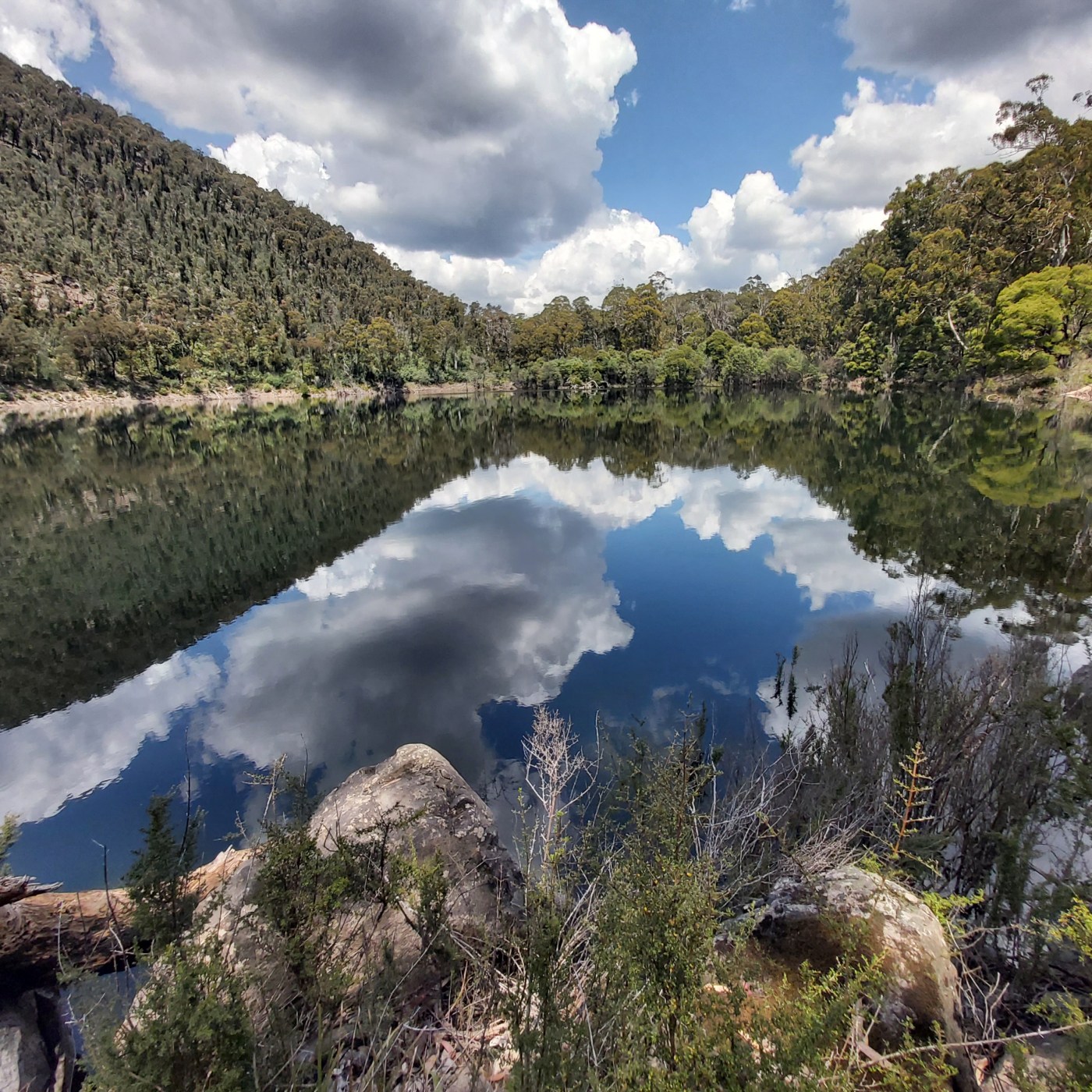
HEADER IMAGE: Lake Tali Karng, Gunaikurnai country.
The majesty of Mt Buffalo

How instinctively we reach for the superlatives – the oldest, fastest, biggest – when we want to distinguish something above its peers.
Mount Buffalo has no such claims on its fellow mountains: it is not the tallest, steepest, or remotest… and say nothing of its dismal snowpack that frays year by year.
There is only one superlative I insist on assigning it. To me, Buffalo has always been the grandest of our peaks.
All of us who have a deep love of a special place know that odd feeling of trying to explain why it is special, and being snagged by the realisation that our love is not simply a replicable product, attributable to its physical features. Buffalo’s vast grandeur has imprinted on me through a mélange of layered memories and sensations of the place. To borrow a phrase from Robert Macfarlane, it is my Mountain of the Mind.
Anna Langford has written a homage to Buffalo – the full story is available here: https://themountainjournal.com/2024/04/21/mountain-icons-the-majesty-of-mt-buffalo/
The local gear shop

Apart from a brief stint delivering newspapers, my first paid job was at the outdoors store in Heathmont, on the eastern fringes of Melbourne. Every Monday afternoon in winter I would head into the shop after school and clean and sort all the ski hire gear (lovely stinky leather boots), then I graduated to doing the hire, and then retail. I had to learn lots about all sorts of gear. I loved talking with the punters about their adventures and plans. And I found my first crew at that shop, friends who I spent years rock climbing with – including my first summer on big peaks in NZ – and enjoyed many weekend walks, and afternoons skiing at Mt Stirling with.
That store, long sold and resold, was kind of like home for me, and I loved all the regulars and locals who would drop in and yarn, looking for that special thing, or a spare length of tent pole, or kitting their kids out with their first set of skis.
All these years later we have been through the chain store boom and bust (remember Snow Gum or Mountain Designs stores?), the slow transformation of the big outlets like Kathmandu from gear stores to outdoor and travel clothing shops, and the rise of online shopping.
But the appeal of the brick and mortar store remains. Fewer in number, they seem more important than ever. Nowdays its as likely to be a bike store as an outdoors shop, but its really all the same thing. Whether it’s Bogong in Melbourne’s CBD, Bruce Easton’s Wilderness Sports in Jindabyne, or Tom’s in Tumut, there’s nothing like wandering into a store where there are real humans with a passion for what they sell. Many climbing/ skiing / hiking dirtbags have done at least a stint in an outdoor store, and they are a rare thing where people get to talk about their passions all day long while at their workplace. And all that local news: how hard is it to get into that crag?, is the spring at that hut still flowing?, when does that road open? You don’t get that from an online store. And apart from being a tangible part of the community, most stores also give back to their community, for instance by hosting or funding events.
If we don’t love them, we will lose them.
Mountain Journal: local gear stores. If we don’t love them, we’ll lose them.
Outdoor magazine: why I love my local gear store.
Mt Feathertop
Dhudhuroa country
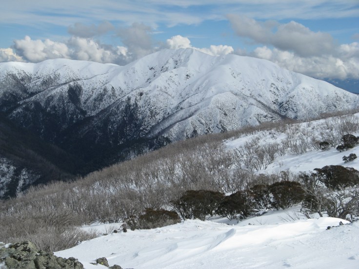
Have you ever climbed Feathertop at night in winter? One of our few ‘real’ mountains on the mainland, the Queen of the Alps has a beautiful and graceful summit ridge that rises from the saddle above Federation hut where the Razorback connects with the mountain itself. You follow a steepening ridge up to a rounded summit that looks out to the Bogong High Plains and northwards to a tangle of lower mountains and valleys. To crunch up icy snow in pre dawn moon light is to experience one of the great adventures of the VIC Alps.
Every skier and rider at Hotham or driver on the Great Alpine Road gazes out at Feathertop. It sits back there, nice and remote, just beyond that graceful line of the Razorback. As you drive south out of Bright towards the mountains it suddenly it jumps out at you in afternoon light, a glorious mountain that rises like a dream above the green valley of the Ovens River.
The eastern face is the stuff of legend for backcountry skiers and riders. Hellfire and Avalanche Gullies provide a sometimes spooky and atmospheric mountain environment. In the right conditions it has amazing snow and ice climbing and remains a coveted destination for many people who have spent their lives on the lifts at Hotham and gaze out at that impressive face. Regardless of the conditions, the eastern face offers steep and serious mountain terrain.
There is lots of history out there too. From the plans to expand the Mt Feathertop Bungalow into a much larger hotel during the 1920s to the proposal for a gondola from Harrietville (!!), and current plans to allow privately run accommodation just near the mountain’s summit, it has been a contested place for well over a century. In the 1980s there was even a plan for a rack railway from Harrietville to Hotham, with a station planned for The Razorback roughly half way between High Knob and the Great Alpine Road!
It is a mountain experiencing change. The old Snow Gum woodlands of The Razorback and the mountain itself are mostly burnt now, and recovering from the last few decades which have seen multiple fires associated with climate change.
Miners, cattlepeople, then skiers and walkers have visited in droves. It is understood that the first skiing on the Razorback was in either 1900 or 1902. Despite the many attempts to develop it, it remains the people’s mountain, a place of refuge, loved by generations of Victorians.
Jim Brown and Jack Wells, stockmen from Cobungra Station, named the mountain in 1851 basing the name on the feather shaped plume of cloud that is often seen on the east side of the summit. I do not know any indigenous names for the mountain. The mountain is on the lands of the Dhudhuroa people.
There is an interesting history on the mountain here by David Sisson.
There is a gorgeous short film by Taylor Bennie-Faull called the Australian Alp
For some discussion on indigenous names for Australian mountains, check here.
The track crews

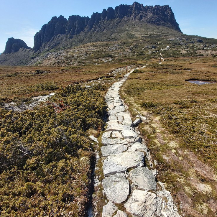
I reckon we all enjoy a good, well formed trail. From the mountains of lutruwita/ Tasmania to the northern Snowy Mountains, our tracks are built and maintained by contractors, parks staff and many volunteers. In some places track building is a form of art (in the USA the stone foundation of tracks are sometimes called rip rap, and have inspired poetry and literature, for instance Rip Rap by Buddhist poet Gary Snyder). In all places they are necessary human creations to allow us to move freely through the landscape.
Tracks are the pathways by which we follow our dreams to find adventure in the mountains. While walking them we may forget to thank the people who built them, or we might marvel at the practical beauty of their work.
Our longest mountain walking track (the Australian Alps Walking Track, or AAWT) is kept navigable due to the efforts of Parks Victoria and other government staff and the wonderful volunteers of BTAC – Bushwalking Tracks and Conservation. BTAC works include clearing fallen trees and vegetation from existing walking tracks, building or repairing boardwalks, installing or replacing track markers and signage, and identifying and removing noxious weeds. They have a preference for working in the more remote areas of the high country where there will be fewer volunteers able to keep tracks open.
Nowdays you are likely to see beautifully crafted mountain bike trails in many mountain areas. But the older networks of tracks, which grew from the pathways of First Nations people, miners, cattle families, hydro workers and many others, remain as a testament of human intervention in the land for pragmatic and visionary reasons.
For further information on BTAC, check here.
For a piece on the changing nature of tracks at Lake Tali Karng, check here.
Not all tracks are good – for instance the plan for commercial development within the Alpine national park in Victoria, which will see a new track replacing the rough route up Diamantina Spur near Mt Feathertop.
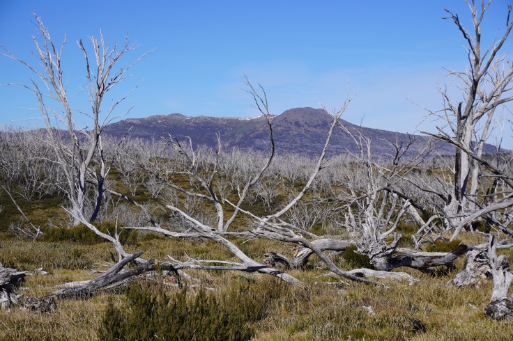
Mt Jagungal
Ngarigo and other nations
From the Main Range of the Snowy Mountains, Jagungal sits as a hulking mass way off to the north. As you walk from the Round Mountain trailhead, it appears as a gorgeous mirage of high peak sitting beyond the rolling high country plains. When you finally get close, it seems like a large hill rather than a mountain and, as you climb its flanks, the views unfold into an endless crumpled mass of snow plains and distant mountains.
Jagungal is the northernmost peak in Australia over 2,000 metres above asea level (it sits at 2,061 metres). It is wonderfully isolated, and sits in a tangle of plains that make up the ‘central’ Snowy Mountains, that high alpine zone between Kiandra and the Main Range. While the surrounding snow gum plains have been devastated by wildfire, the mountain itself feels ageless and unchanging. The impact of the fire is shocking and it can be depressing to walk through what seems like endless torched wasteland.
The surrounding area is a wilderness zone and because it stands alone in an extensive plain, the mountain is visible for many kilometres in all directions, and draws you on as you plod across the plains. With extensive snow plains, shallow valleys and recovering snow gum woodlands, this area has a strange same-ness of form, except for the mountain itself. There are some great huts (many have been burnt in recent years), plentiful water, and great camping. In a good winter the touring can be wonderful and has such a feeling of quiet and remoteness. It should definitely be on your ‘must climb’ list of mountains.
Mt Geryon
luruwita/ Tasmania
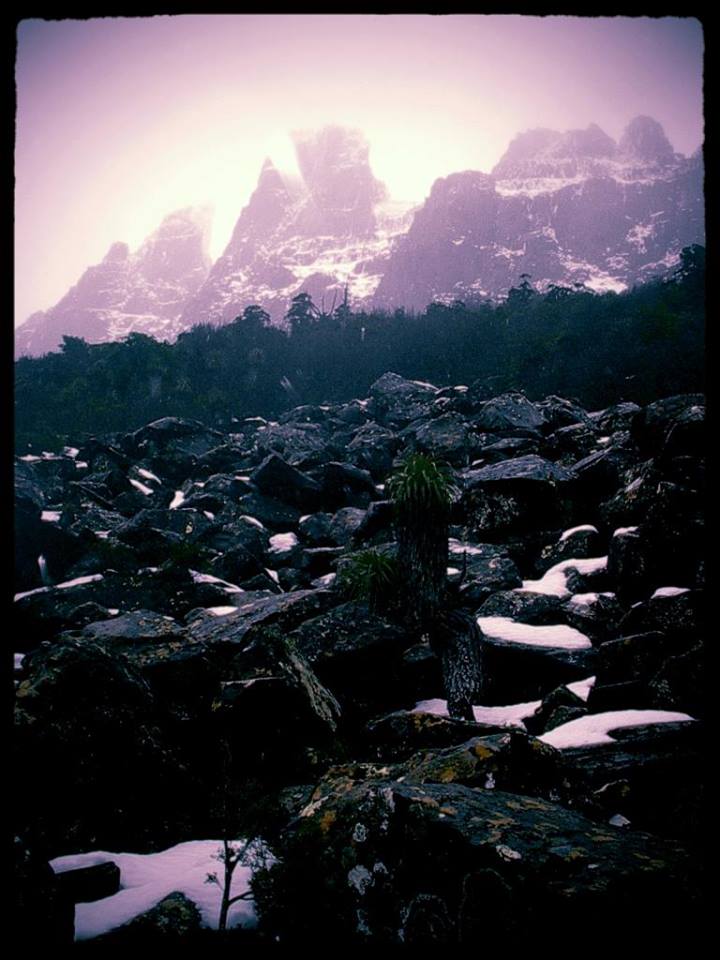
I don’t know any Indigenous stories about Mt Geryon, in the southern end of Tasmania’s Cradle Mountain Lake St Clair National Park. But I do often wonder what it must have been like for the people who lived and passed through the incredible mountain country of central western Tasmania. To approach this mountain up Pine Valley and finally to reach the small clearing (the old ‘climbers camp’) where the bulky western face suddenly reveals itself is always an impressive, and to me, spiritual, experience. I wonder if they climbed this peak.
I really cannot think of a more beautiful mountain. Tucked away in the ranges of the central west, Geryon is a sharp peak that sits like a treasure next to the alpine paradise of the Labyrinth, linking the Ducane Range with the Acropolis. Although the Labyrinth is popular with walkers on the Overland Track, getting to the north peak of Geryon is quite a commitment, with a long climb from Pine Valley then wander past the Pool of Memories and on to the Ducane Range and finally, the last section involving a scramble to a narrow mountain top.
The eastern and western faces offer some spectacular rock climbing (with routes on the east side passing 340 metres in length). The great Cephissus scree, which runs from the base of the western face down almost to Cephissus Creek, is an amazing feature, and acts as a giant staircase that leads you right to the cliffs under the summit.
If you are drawn to mountains and wild landscapes, then Geryon is a must. To wind your way past glacial lakes, through groves of pencil pine and deciduous beech, as you slowly pass under the grey ramparts of Geryon’s western face would have to be one of the best walks in all of Australia. To also include the climb to the north peak makes for an unforgettable experience.
https://tasmaniangeographic.com/mount-geryon/
Australian Alps Walking Track, the AAWT.

Spanning some 680km the AAWT traverses the highest peaks of the Australian Alps, winding it’s way from Walhalla in Victoria to Tharwa in ACT. Along the way it passes through Baw Baw National Park, Alpine National Park, Kosciusko National Park, Namadgi National Park, numerous State Parks and Historic Areas and through 14 seperate Aboriginal regions.
A celebration of all things alpine, the AAWT is … layers of blue grey mountains stretching as far as the eye can see, snow gums gnarled through age and harsh weather, isolated huts providing emergency refuge, peatlands and bogs that feed meandering mountain streams that in turn create some of our major river systems, extreme weather that only the mountains can generate, unique and endangered flora and fauna found only in the alpine or sub-alpine zone.
It is also the impacts of humans on the natural landscape through the construction of ski resorts and management tracks in the wilderness, logging, bushfires and damage caused by introduced weeds and feral animals. The AAWT is an isolated long distance walk requiring walkers to be well prepared, experienced and self sufficient. In turn you’ll be rewarded with majestic and awe inspiring vistas, days governed not by the clock but by the daylight and weather, immersed in a landscape like no other in Australia and develop an appreciation for a unique and fragile ecosystem.
Alicia Crossley
Bright Brewery
Dhudhuroa country
There is a growing tide of micro breweries that has spread across the country. There are currently around 800 craft brewers nation wide. They provide a welcome locally owned alternative to the huge global beer brands that dominate beer production and sales (be aware that these companies are buying up or establishing craft operations, so always check the label to see who actually owns the business). Being locally owned, they are usually good citizens, and each one is different and often a reflection of the community where they are located.
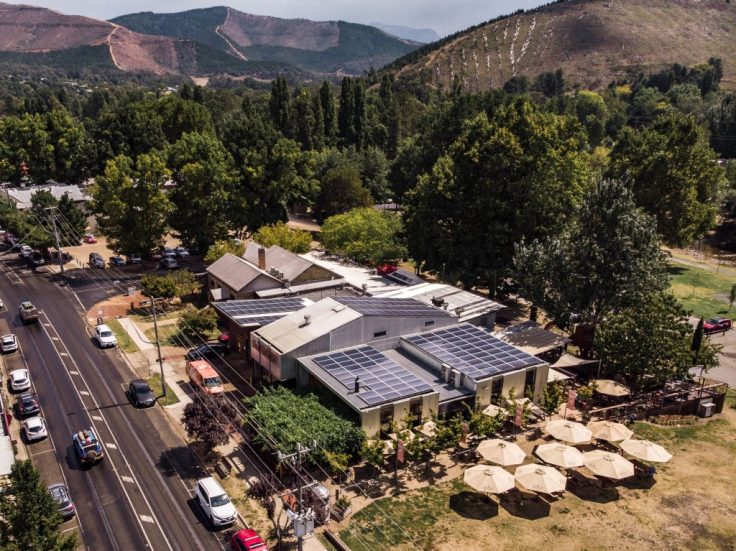
Bright Brewery stands out as one of the best known breweries in and around the high country. It was born in 2005 from a passion for well-made beer, a love for the town of Bright, the local alpine environment, and the adventurous outdoors lifestyle that the High Country provides.
From day one, the Brewery has been driven by its values, which were instilled by founders Scott Brandon and Fiona Reddaway. The brewery aims to be authentic and sustainable in all that they do, and to embrace active lifestyles, celebrated with great beer.
To this day, these values form the backbone of Bright Brewery.
Bright Brewery gives back to the community, including entering into partnerships with local community groups and advocacy organisations like Protect Our Winters Australia. Scott says “we work really hard to be active in our local community, and to help create a sustainable community”.
Bright Brewery has a charter to support local, and it prioritises local events, organisations, individuals, groups, and charities across a huge range of activities. It supports the local trail–running chapter of Trails and Ales, the local Women’s Mountain Biking group, the Alpine Cycling Club, the Autumn Festival, the Myrtleford Bowls Club, and many more.
The brewery is also working to reduce its environmental footprint through a range of measures including installing solar panels to produce electricity. Its mission is to ‘minimise our overall environmental footprint on our natural environment.’
“We are about to add another 177kW of solar to our brewery,” Brandon said. “This is in addition to the 50kW of solar already at the venue.”
These solar panels will completely offset the company’s power usage, making it 100% energy self-sufficient.
https://brightbrewery.com.au/sustainability/solar-brewing/
Cradle Mountain
Yes, Cradle is an obvious addition to this list. Cradle Mountain is arguably our best known and photographed mountain. Acting as the entry point peak at the north end of the Cradle Mountain Lake St Clair national park, this wonderful rocky mountain is strangely alluring. From any direction it has an aesthetic profile and is doable as a day walk and, from the north, it is framed by Dove Lake. As a mountain it seems remote and attainable at the same time.
Go there on a summers day and you will be dazzled by how many people make the pilgrimage. Early in the day it’s the trail runners and hard core walkers, but by lunchtime it’s the families and assorted unfit people who seem out of place as they clamber over the first boulder field (asking those coming back ‘how far is it’?). Many people seem a bit out of their depth but are soaking up the sublime mountain scenery and the need to clamber over the mountain to reach the summit ridge (and, damn, then you have to go down and climb up again to reach the true summit). Then, by late afternoon as you head back to the bus, all the tourists who made it as far as Marion’s Lookout to get some selfies over Dove Lake are standing around and grinning at this amazing place.
Australians tend to be a fairly sedentary and car focused people. But once we get to Cradle Valley, we are drawn to that peak. And, to paraphrase The Wizard of Oz, this ‘isn’t Kansas anymore’. It’s a weirdly strange yet familiar land, with wombats and Pencil Pine, glacial lakes and button grass, ancient rainforest and alpine plateaus, and then boulder fields and a rocky skyline. It is profoundly and uniquely Australian, and yet so different from the places most of us inhabit. As you climb higher, the glaciated landscape unfurls around you. Australians in their thousands throw themselves at the familiar yet exotic mountain and come home sunburnt, tired and delighted after a wonderful day on the hill.
Gorgeous as it is, for me Cradle is a gateway to the mountains deeper in to the really wild country to the south. Pelion West, Barn Bluff, Oakleigh, Thetis, Ossa and that mad tangle of hill and valley that stretches out from the summit draws my eyes and makes my spirit sing. But I feel grateful that this mountain seems to be able to make us all hopeful mountain dreamers for the day.
Baw Baw Plateau
Gunaikurnai country

If you’re after steep winter runs, you probably need to go somewhere else. But if you’re looking for some cool air among the snow gums, frost hollow valleys and views through the trees of distant valleys and mountains, Baw Baw will fit the bill.
This southern most end of the Australian alps is a long thin plateau that sits on top of old granite country, more resembling the Buffalo plateau than most of the Victorian high country. Its small resort and lodges among the trees, network of walking tracks, and easy access from the eastern suburbs of Melbourne and the Latrobe Valley makes it a favourite with those communities.
What really makes it special are the long unburnt snow gum woodlands that cover the plateau. As fire seasons get longer and more intense, the majority of snow gums have burnt in recent years, often multiple times. Baw Baw is an unburnt refuge which becomes more precious by the year. The icing on the cake are the pockets of Beech trees (Nothofagus cunninghamii) that are scattered among the snow gums, which give a truly magical experience, especially after fresh snow.
Sadly much of the surrounding alpine ash forests that ring the plateau have been logged, leaving a messy fuzz of dead trees and thick regrowth. But the two winding roads that climb onto the plateau are a delight to drive (and thankfully, plans to build a road across the plateau were defeated long ago).
Vallejo Gantner hut
Gunaikurnai Country
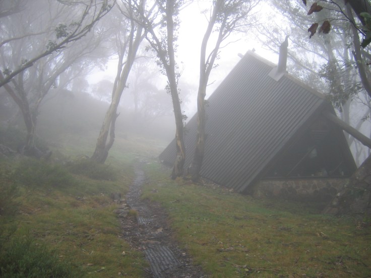
The Vallejo Gantner Hut sits on a slight rise above Macalister Springs, a permanent spring that was long ago polluted by cattle and now serves as a high elevation water source in what can be dry mountain country. It is near Mount Howitt and the fabled Crosscut Saw (a more remote version of the famed Razorback), to the east of Mt Buller. To me, it feels like it exists at the heart of the Victorian Alps, remote and silent and in a truly beautiful place. Like a number of huts across the high country, it was built as a memorial following the death of Vallejo Gantner, the grandson of Sidney Myer, the founder of the Myer department store chain. Construction commenced in late 1968.
Vallejo Gantner is a charming A frame hut, with a small loft, big windows, and lovely fireplace. It also has the ‘loo with a view’, which looks into the upper Macalister River valley.
It is nicely remote. In summer, Vallejo is a reasonable walk from the Howitt road but it really comes into it’s own in winter when it becomes a magnet for backcountry skiers and riders. It is a long tour in from The Bluff, Lake Cobbler or from the south across the Howitt Plains. In this season it is truly a wilderness escape, a welcome refuge in an unburnt forest, seemingly miles from anywhere.
Moora Moora Co-operative
Wurundjeri country
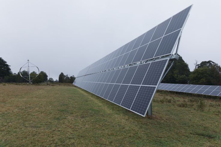
Moora Moora Co-operative is an intentional community that thrives on a magic mountain near Healesville. Next year will be our 50th birthday, and we are still going strong.
In 1974, one of the attractions of the property was NO connection to mains electricity. In fact, in 1978 we did our best to stop the SEC from forcing it onto the mountain, to the point of being arrested for blocking the road. Labor promised an environmental effects study—then lost the election by one seat. So, the power line came through, but Moora Moora didn’t connect on.
We used solar panels when they were tiny and inefficient, and despite the fluky, changeable wind, have been experimenting with wind power all this time.
See that eggbeater shape in the photo? It’s a Darrieus rotor. It would probably have worked, except the council required changes that mean it may do so where regular gales blow. Now it is a beautiful sculpture backing modern solar farms that follow the sun for increased efficiency.
This pic was taken in the morning, the solar farms eagerly seeking the eastern sun.
You can read about the history of the Darrieus rotor at http://mudsmith.net/darrieus.html and check out the Moora Moora co-operative at https://mooramoora.org.au
Bob Rich


July 21, 2023 at 9:33 pm
Cam, I am waiting for Glen Morris to provide me with a pic for this.