A considerable number of fires continue to threaten Tasmania’s protected areas. These happened as a result of more than 9,000 lightning strikes which have happened since tuesday 15th January. Increased dry lightning strikes, prolonged dry summers and high temperatures are consistent with what climate science says is coming in terms of fire risk in Tasmania.
While the large Gell River fire raised concerns about impacts on fire sensitive plant communities early in the month, some of the new fires also threaten non fire adapted vegetation in the south west and the Central Plateau.
There are several fires burning on the Central Plateau, including one at Great Pine Tier, which is described as being ‘uncontrolled’ and which threatens the township of Miena. An emergency warning was issued for Miena yesterday afternoon (21/1/19) but has since been downgraded to a watch and act alert.
The Parks Service and Tasmanian Fire Service (TFS) are identifying where the lightning strikes have occurred, where the fires are going and what natural and cultural values are potentially at risk. This forward planning will assist to identify priority areas for protection from fire.
Bushwalkers have been extracted from the Mt Anne area. Helicopters were flown over the walking tracks in the Southwest National Park, including the western and eastern Arthur Range, and hikers assisted in leaving the area. To date, 43 people have been airlifted to safety.
Check here for the full list of current fires.
The Parks and Wildlife Service (PWS) strongly advises that people ‘not to venture out into remote areas, either by foot or by vehicle during the current fire situation, unless you can obtain reliable information from a PWS visitor centre as to the safety of the area you propose to visit’.
Check here for updates on what parks are closed.
The Mount Anne fire
This report comes from the Tasmanian National Parks Association:
“The fires in the Mt Anne area are currently of the highest priority to the Parks and Wildlife Service (PWS) due to the presence of sensitive alpine vegetation at Pandani shelf and King Billy pine communities.
• The active fires in the Mt Anne area include Huon Inlet (517 ha), Celtic Hill (1333 ha), Anne Gorge (902 ha), Gallagher Plateau (17 ha) and Anne River (81.4 ha).
• Fire suppression using aerial bombardment has been ongoing since the first days following ignition.
• The Celtic Hill fire is burning in an easterly direction up Deception Ridge and the walking track at Condominium Creek towards Mount Anne and North East Ridge. There is a large tract of wet forest and rainforest between the fire and the North East Ridge which PWS anticipates will assist to hold the fire and prevent further incursion in that sector of the fire.
• Under current soil moisture conditions the fires appear to be burning in drier aspects of wet forest.
• The Anne Gorge fire has burnt up the western side of Schnells Ridge but no further fire activity has been reported today.
• The plan is to reduce the impact of both the Celtic ridge and Anne Gorge fires from entering the Anne range using strategically located retardant and sprinkler lines and a back burn on the Lk Judd Track.
• Large Air tankers will be deployed to lay retardant lines on Tuesday 22 and/or Wednesday 23 Jan subject to the availability of aerial equipment and suitable weather to conduct the operations.
• The second phase of the plan involves deploying sprinkler systems to critical habitat locations including Pandani shelf; Mount Lot-Lk Picone; west of Eliza Bluff, etc.
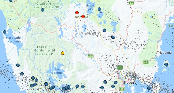
IMAGE ABOVE: map showing lightning strikes across TAS.


Leave a comment