The Bureau of Meteorolgy has released its national climate summary for January 2019. As expected, it shows that it was the country’s warmest January on record for mean temperatures (2.91 °C above average), maximum temperatures (3.37 °C above average) and minimum temperatures (2.45 °C above average). Rainfall for the country as a whole was 38% below the long-term average for January, and Tasmania had its driest January on record.
After a dry winter and spring in the south east and then a sustained heatwave, its fairly obvious why its been a horror summer for fires. Tasmania and Victoria still have a significant number of fires which are not contained, let alone under control. And there is no obvious break coming to this hot, dry weather. The ecological costs of this summer’s fires are already becoming apparent.
Thomson catchment, Victoria
The Thomson River catchment, to the east of the Baw Baw plateau, is part of Melbourne’s water supply. It is at the heart of the Mountain Ash forests which are at threat from logging and climate change. Like many areas in the Central Highlands, it has been fragmented by intensive logging.
As of early February, 4,500 hectares of the catchment had been burnt. This will have long term impacts on water supply out of the catchment (regrowth forests consume more water than older forest) and means further destruction of the Mountain Ash forests.
There are concerns that firefighting efforts could inadvertently pollute the water supply, which receives little treatment before it is pumped into Victoria’s water system.
“Immediately after a bushfire there is sediment run-off, ash, and erosion so that pollutes the waterways, and it can clog up water ways and impact the quality of water,” said Chris Taylor, from the Australian National University.
Eastern Victoria
A fire continues to burn north and north east of Buchan in the foothill forests of the VIC Alps (roughly 15,404 hectares burnt as of early February).
Its been a bad summer for dry lightning strikes and they continue to cause fires throughout the Alps, often in remote areas. Check the Emergency VIC website for updates.
Tasmania
Tasmania is where the summer fires have been particularly devastating. There are obvious threats to rural communities and houses in the urban/ bush interface. But the threat to vegetation cannot be over stated. Tasmania is the stronghold of ancient vegetation that dates back to the times of the Gondwana super continent. These ecosystems, which pre date the development of eucalypt forests, are badly affected by wild fire. This includes rainforests and alpine areas, which often can take centuries to recover from fire.
As noted by photographer Rob Blakers:
“Fire is now at the foot, and directly upwind, of the Western Arthurs, of Federation Peak and of the Mt Bobs/Boomerang complex. It has been well over a month since any significant rain. The run of sustained high temperatures has smashed records. With continued high temperatures and wind, these places will burn. They are at the apex of the Tasmanian Gondwanan identity – the King Billy pine forest at Mt Bobs is on a par with that at Mt Anne and is of global significance.”
At great risk are stands of Pencil Pine (Athrotaxis cupressoides) which is a slow‐growing and long‐lived conifer that occurs in the subalpine temperate forests of Tasmania. It is already at risk from fire and this is expected to increase because of a ‘warmer and drier climate’. Significant stands of Pencil Pine have already been burnt this summer.
To make things worse, the hand of climate change is apparent in these fires. These are not ‘natural fires’ as we historically understand them. Dry lightning strikes of the type that ignited scores of fires in southern Tasmania over the last month have been exponentially increasing since about the year 2000. More than more than 9,000 lightning strikes were recorded in a week across Tasmania, which resulted in many new fires.
The Gell River fire, which started as a result of a lightning strike on December 27, has burnt massive areas of the South West World Heritage Area. The Parks and Wildlife Service and the Tasmanian Fire Service have waged an epic campaign to protect sensitive areas like Lake Rhona, Mt Anne and Mt Bobs. But the fire has continued to grow and has now burnt for a full month. A series of lightning storms set off another chain of fires from January 15 onwards.
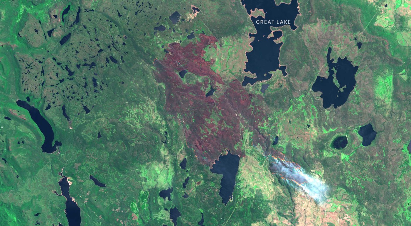
A major fire on the northern end of the Central Plateau near the Great Lake has impacted on fire sensitive vegetation including Pencil Pine.
The Tahune fire in the south east has caused the most human displacement, forcing hundreds of people to evacuate from communities in the Huon Valley south of Hobart.
As of February 3, about 40 fires are still burning across the state, and more than 189,000 hectares have now been destroyed. Tasmania Fire Service chief fire officer Chris Arnol says “We are not out of the woods yet”, with more serious fire weather on the way.
Professor of pyrogeography and fire service at the University of Tasmania David Bowman says “This is definitely a historic event, it’s unprecedented”.
[IMAGE: shows the Great Lake fire on Jan 28. Satellite images by Mark Doman].


Leave a comment