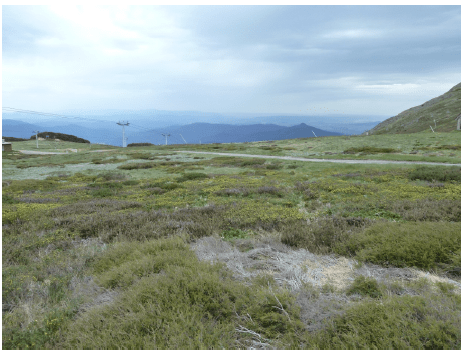
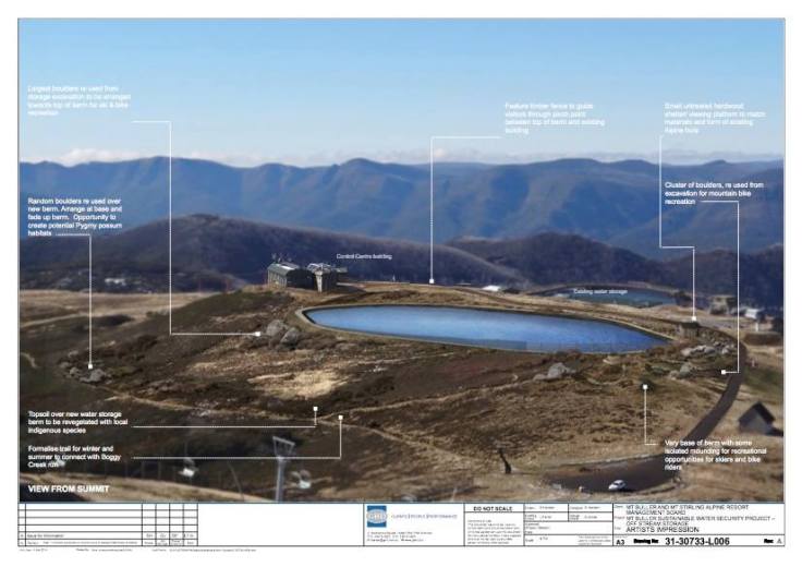
Since at least 2014, there has been a proposal to construct a 100 Megalitre dam near the summit of Mount Buller. The official title of the project is “Mt Buller Sustainable Water Security Project”. The project involves the destruction of about 5 hectares of treeless alpine native vegetation, and subtracts about 10 hectares from the existing downhill skifield on Mount Buller.
Federal legislation requires a period of time to allow interested people and organisations to comment. Submissions are due by 22 December.
The following information comes from Friends of Mount Stirling.
If approved, the proposal requires the creation of an “offset”, that is, a larger area with the same “natural values” as the area destroyed. The offset is to be protected in perpetuity. As the area to be destroyed is a very rare ecosystem in Victoria, there are few places where such an offset could be declared. It is proposed that the offset would be 262 hectares around the summit of Mount Stirling.
Due to the environmental sensitivity of the project, it is not only subject to State regulations, but also the Commonwealth Environment Protection and Biodiversity Conservation (EPBC) Act.
A notice calling for public comments under the EPBC Act was published in the Herald Sun newspaper earlier this week.
Official documentation can be found here http://rmb.mtbuller.com.au/community-noticeboard.php
More documentation can be found here https://www.dropbox.com/sh/izrafd2blh2iuvq/AADRSiohc0yo0acZ2XEgMvyla?dl=0
What area will be affected?
According to the report prepared for Mt Buller, most of the area to be destroyed is ‘alpine grassy heathland’.
‘The Project is within the Victorian Alps Bioregion. Field assessments … indicated that three remnant vegetation Ecological Vegetation Classes (EVCs) are currently present within the ‘Project Construction Footprint’ (PCF):
Alpine Grassy Heathland (EVC 1004)
This is the most abundant EVC across the PCF, covering a total area of 5.832 ha.
This EVC is a high altitude open heathland dominated by tussock grasses and a range of forbs. It occupies a wide range of habitats generally on slopes above 1,400 m where exposure and frost are limiting to tree growth. Graminoids and forbs are abundant and vary in cover depending on shrub density.
Sub-alpine Wet Heathland (EVC 210)
Sub-alpine Wet Heathland is highly localised within the PCF, restricted to a small area north-east of the existing water storage tank, and covering an area of 0.082 ha.
Sub-alpine Woodland (EVC 43)
Sub-alpine Woodland is confined to a few localised patches (0.004 ha) within the PCF, where it occurs immediately downslope of Alpine Grassy Heathland, growing on skeletal clay loams with a rich humus topsoil layer. This EVC is a low, open woodland dominated by Snow Gum with a rich suite of grasses and herbs, or a dense layer of woody shrubs.
Submissions are to be delivered by 22 December 2017, as follows;
You can post to:
Mt Buller Mt Stirling Resort Management
Alpine Central
Summit Road
Mt Buller, Victoria, 3723
Or send via email: waterstorage@mtbuller.com.au
If you, or your organisation, has a point of view about this proposal, The Friends of Mount Stirling encourage you to make a submission. Whilst submissions are requested by Resort Management, everyone is also at liberty to copy their submissions to the State Minister, the Hon. Lily D’Ambrosio at lily.d’ambrosio@parliament.vic.gov.au , and the Federal Minister, the Hon. Josh Frydenberg at https://onlineservices.environment.gov.au/contact-your-minister/eform
This submission prepared by Friends of the Earth may assist you in preparing yours.
The Friends of Mount Stirling also encourage you to express your point of view on our Facebook Page at https://www.facebook.com/StirlingFriends
Please feel free to copy and share this post.


Leave a comment