Over the summer of 2018/19 huge fires burnt across Tasmania. An independent review of Tasmania’s management of the summer bushfires has just been released. It found inadequacies in the response to a fire burning near Geeveston, and revealed that crews withdrew from the Gell River fire in Tasmania’s south–west in the mistaken belief it was out. The fire then expanded again and became out of control.
It makes a series of recommendations for the fire services and government, including a proposal to re-establish a volunteer remote area firefighter group. The report, from the Australasian Fire and Emergency Service Authorities Council (AFAC) also gives an update on the ecological impacts of the fires. An earlier ecological assessment is here.
The following comes from a report by political reporters Alexandra Humphries and Rhiana Whitson at the ABC:
Key points:
- The report says 3 per cent of the state was burnt in the summer’s bushfires, including more than 95,000 hectares in Tasmania’s World Wilderness Heritage Area
- It says “with the benefit of hindsight, the Gell River fire could have been handled differently”, but was managed according to acceptable industry practice
- The report also says “shortcomings in management” of a fire in the Huon Valley “were not down to interagency rivalry”
“The review, conducted by the Australasian Fire and Emergency Service Authorities Council, confirms the summer bushfires were the second-largest bushfire event in Tasmania’s history only behind the catastrophic events of 1967.
The bushfires occurred during the state’s second warmest summer on record, resulting in dry fuel loads.
The three main fires were started by lightning strikes at Gell River on December 27, and at the Great Pine Tier in the Central Plateau and Riveaux Road in the Huon Valley on January 15.
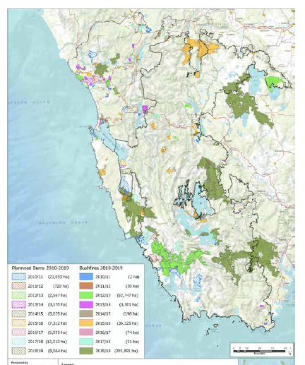
The fires burned through 210,000 hectares and put communities such as those south of Huonville and in the Central Highlands at risk for weeks between December 2018 and March this year.
The report found inadequacies in the response to a fire burning near Geeveston, and reveals crews withdrew from the Gell River fire in Tasmania’s south–west on the mistaken belief it was out. It also criticised the $40 million spent on aircraft, and found a purpose-built state operations centre is needed to replace cramped facilities at Cambridge, near Hobart.
The report found the Tasmania Fire Service was aware of the potential danger posed by the Pear Hill fire west of Geeveston, which later became the Riveaux Rd fire and burned into the Southwood mill, but did not take steps to ensure proportionate resources were directed to combat it.
The report said the danger was not made clear to the Parks and Wildlife Service — the agency in charge of managing the blaze — in an apparent communications breakdown, and the PWS did not have resources to combat the fire.
It said multiple sources claimed fire suppression activities did not take place on the Pear Hill fire for a number of days.
Tasmania Fire Service acting chief officer Bruce Byatt said fire agencies were forced to make quick decisions about which fires to prioritise.
The review heard crews attending the Gell River fire in the state’s south-west were not properly resourced, with no aircraft available to identify hot spots, and that crews withdrew from the fire line too early because they believed it was inactive and did not pose a threat.
“This unfortunately proved not to be so, with the fire later burning freely to the south,” it noted.
The report also rejects an allegation that Parks and Wildlife Service refused to deploy earthmoving machinery in the TWWHA, but highlighted communication issues, and delays in resource requests.
The report itself (available here) makes a series of recommendations.
Recommendation 1
TFS (Tasmanian Fires Service), PWS (Parks and Wildlife Service) and STT (Sustainable Timber Tasmania) should initiate a discussion among their Australasian peers about good practice around managing new fire starts in remote terrain, to include issues around identification, predictive analysis, risk management and suppression activities.
The outcome should be a document which allows for benchmarking to accepted good practice across Australasia, from which Tasmanian fire agencies can develop protocols against which the management of future events can be tested.
Recommendation 2
TFS should pursue the creation of a cadre of volunteer remote area firefighters. In doing so the TFS should not consider itself limited to upskilling of current volunteer brigade members, but should carry out a cost benefit analysis of creating one or more remote area firefighting units based in urban areas, in order to tap into the potential of those members of the urban-based Tasmanian community who may have advanced knowledge and skills relating to navigation and survival in wilderness areas.
Recommendation 3
TFS should initiate a policy review (seeking support from government as appropriate) to clearly identify what body or agency is responsible for planning, carrying out and enforcing fuel management on private property at a township level.
If current arrangements are unclear or ineffective, TFS should request government to consider making this a statutory responsibility of TFS and provide any additional funding required to support this function.
Recommendation 4
TFS, PWS and STT should work with government and each other to continue to pursue a whole-of-state fuel management and burning program that encompasses all land tenures, meets the range of outcomes required by the state (township protection, risk reduction and landscape-scale burns) and is inclusive of private landholders and local communities as well as all fire agencies.
Recommendation 5
TFS, PWS and STT agree an updated version of the Interagency Fire Management Protocol which maintains the principle that there will be one state-wide point of command for major unwanted fires burning in the State of Tasmania, explicitly recognises the right of each of TFS, PWS and STT to have their objectives prioritised in incident action planning and adequate resources applied to those objectives, and provides a mechanism for executive decision-makers from TFS, PWS and STT to come together and agree objectives and resourcing levels that will then be operationalised by whole-of-State control structures.
Recommendation 6
TFS, PWS and STT should establish a State Air Desk, to be staffed by specialist staff year-round, with responsibility for managing both preparatory and contractual issues out of season as well as aircraft management when fires or other emergency events are occurring.
Recommendation 6A
The proposed Tasmania State Air Desk should have a finance officer attached to its staff.
Recommendation 7
TFS, PWS and STT should jointly reach a decision on whether a winch capable remote area firefighting capability should be maintained in Tasmania; which agency or agencies should be responsible for that program; and how a winch capable remote area firefighting capability can be safely trained and kept current, to include consideration of the availability of winching aircraft. If the decision is taken not to maintain this capability in the state, TFS, PWS and STT should identify how the gap in capability that this represents should be filled in future fire seasons.
Recommendation 8
TFS, PWS and STT should jointly carry out work to identify acceptable shift lengths and patterns – including requirements for rest days – for all personnel working on emergency operations. Once these have been identified, systems should be put in place to ensure that HR rostering practices follow these fatigue management guidelines. And senior staff should lead by example and ensure that they, as well as the people working under them, take adequate rest breaks.
Recommendation 9
TFS should engage in discussions with government about the construction of purpose-built State Control Centre facilities for emergency management in Tasmania.
Causes of fire and climate change
The report notes that “very dry and consistently warm conditions resulted in extreme dryness and rapid curing in most vegetation types including wet forests and moorlands. Vegetation that would ordinarily be too moist to burn became available fuel.
Extensive bands of lightning extended across the western and south western areas of the State on 14 and 15 January, with the second event producing over 2400 dry lightning strikes. The absence of any associated rainfall and hot, dry conditions resulted in over 70 new fires breaking out across the State. Several of these became significant fires”.
Longer drier summers and increased dry lightning strikes are what are expected with climate change.
The report further notes that:
‘The Review received a number of submissions that suggested dry lightning is becoming increasingly evident in Tasmania. While changing climate is undoubtedly resulting in altered weather conditions and may be influencing patterns of lightning, we heard there are other significant factors that may also be involved.
Of particular note is the technological advancement which has significantly enhanced lightning strike tracking capability over the past decade. Simply put, the Bureau of Meteorology has developed enhanced capabilities to better detect lightning, so it is difficult to establish conclusive trends from simple analysis of historical data. What may be evident is that a combination of soil dryness and fuel curing in historically ‘wet’ vegetation communities is facilitating increased ignitions from lightning strikes than may previously have occurred.
Consistent with fire events in Tasmania and other jurisdictions over the past decade or more we heard reports of firefighters witnessing unusual and unpredictable fire conditions they had not previously experienced.
This included fires carrying through very tall ‘wet’ Eucalyptus regnans forest and burning through rainforest ecotone vegetation communities that would ordinarily provide natural control lines.
Consistent with strong scientific evidence and following the significant fire events in Tasmania in 2013, 2016 and 2019 there is broad acknowledgement and acceptance that projected changes to climatic conditions will result in longer, more severe fire seasons for the State, as with other parts of the country. This will only become more challenging as the weather windows open for prescribed burning shift with changing climatic patterns, adding uncertainty and complexity to burn planning”.
Ecological impacts
It also outlined the scope of fire sensitive vegetation was impacted by the fire:
Preliminary desktop assessment indicates that a total of approximately 2,300 ha comprising thirteen different Threatened Native Vegetation Communities were within identified burn areas in the TWWHA. Importantly, the large majority of threatened vegetation in those areas are classified as having low – moderate fire sensitivity. This includes over 1800ha of highland grassland and sedgeland that were burnt in the Great Pine Tier fire.
Four extremely fire sensitive endemic conifer communities were fire affected. Although only small areas in terms of total population extent (<0.1 – 0.2%), these communities contain King Billy Pine Athrotaxis selaginoides or Pencil Pine Athrotaxis cupressoides that will not recover from fire.
Significant Vegetation
Significant areas of alpine heath, sedgeland and grassland occur within the boundaries of the fires, although at this stage it is unknown how much of this has actually been burnt. Most of this potentially impacted vegetation is within the Lake Fergus and Gell River fire areas. The ‘Arve Big Tree’ has been confirmed as destroyed. To date, visual assessment of the Centurion tree in the Riveaux Rd fire suggests this tree has not been significantly impacted.
Very Tall Forests
Forests more than 70 metres in height are globally rare. Tasmania has approximately 6318 ha of very tall eucalypt forest over 70 m in height. Approximately 14 per cent of Tasmania’s very tall forests were burned: 296 ha by the Gell River fire, which includes parts of the largest patches of very tall eucalypt forest within the Coles Creek area on the Gordon Range, and another 607 ha by the Riveaux Road fire.
Myrtle-beech rainforests
Mapping of myrtle-beech dominated rainforests shows 7000 ha within the perimeter of the fires, with the largest areas being within the Moores Valley/Dolphin Ridge (2900 ha), Riveaux Road (2500 ha) and Lynch Hill/Western Hills (1400 ha) fires.
Firefighters
As a foot note, the report identified that there were 156 ‘safety incidents’ reported involving staff during the summer’s fires. Firefighters put themselves on the line to protect landscape and human life and property. Thank you, firies for your efforts and bravery.
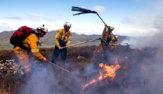
The image used at the top of this story comes from the report and was taken by Warren Frey.


Leave a comment