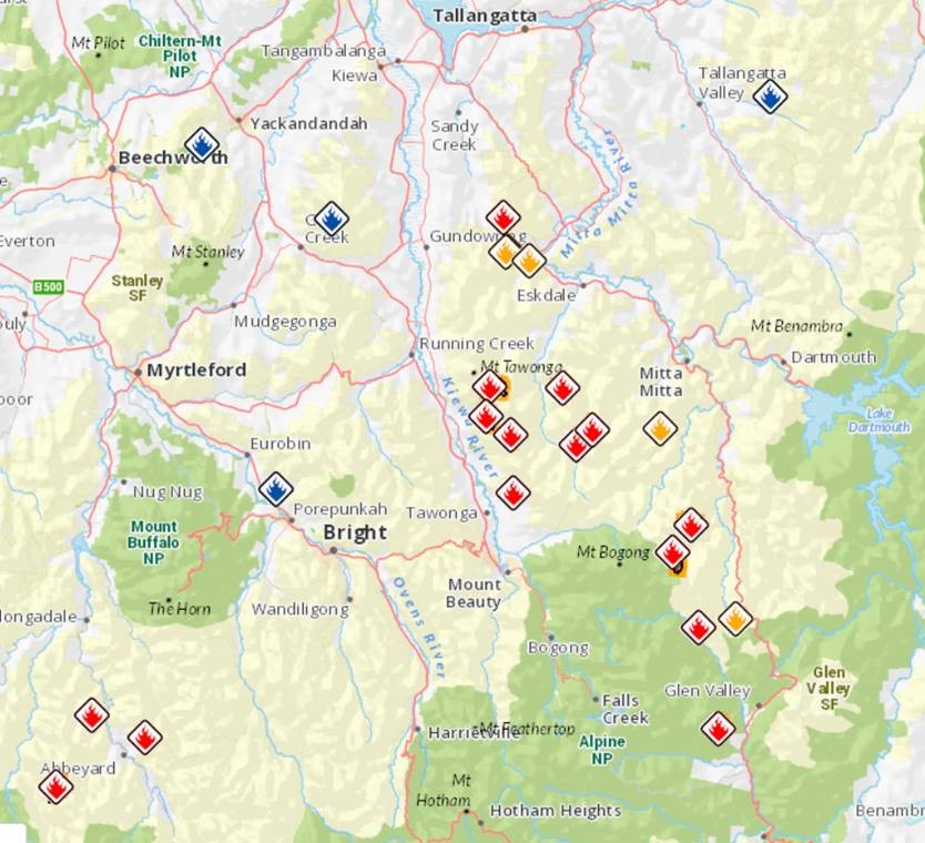
There are a number of fires that have started as a result of lightning strikes in the Victorian High Country.
There are three fires in the north east that have caused a number of areas to be closed to walkers – these are to the east of Mt Bogong and two along the eastern side of the Bogong High Plains.
Additionally, there are 13 fires in total burning in remote areas of forest in north east Victoria. The other fires are located in the Tallangatta Valley, Dandongadale, Abbeyard and Mount Selwyn.
DELWP says: ‘The remote locations of these fires are proving to be challenging for our crews and we fully expect them to burn for a number of weeks as firefighters work hard to contain them’.
Authorities say that the fires are behaving in ways expected in January and February as fuel loads are so dry.
This is updated as conditions change. More recent updates will be posted at the top of each section.
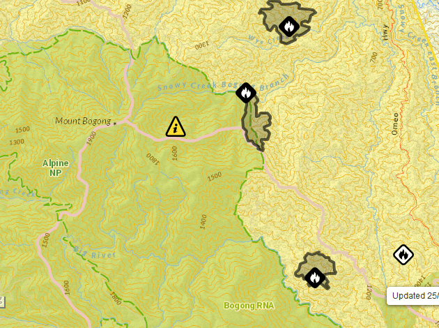
Bogong High Plains and Mt Bogong fires
Update Friday 29/11/2019
The fire is burning along The Long Ridge towards Bosseide Hill and is considered ‘not yet under control’.
Update Tuesday 26/11/2019
The fire continues to burn uphill towards Mt Bogong. It is classed as being ‘not yet under control’ and has grown to 376 ha. The following roads remain closed: Omeo Hwy between Benambra-Corryong Road at Omeo and Mitta Mitta.
By monday 25th, the Bogong fire had grown to 300 ha in size.
Bushwalkers in the Mount Bogong High Plains and Mt Bogong areas are being advised to leave immediately via Staircase Spur, Quartz Ridge Track, Eskdale Spur or Granite Flat Spur, to ensure their safety following the closure of a number of walking tracks in the area.
There is a bushfire at 15 Km Ssw Of Granite Flat that is not yet under control.
The bushfire is travelling up hill towards the peak of Mt Bogong.
Multiple fires continue to burn in the Mount Bogong area, which were ignited by lightning on Thursday, 21 November. The fires have grown in size, the largest being an estimated 300-hectares.
Parks Victoria say:
“The Bogong High Plains and Mount Bogong have been closed due to fires. The affected area is to the south of Mountain Creek Road, north and east of the Bogong High Plains Road, and west of the Omeo Highway. The closure includes the Mount Wills Historic Area and this section of the Alpine Walking Track. The Omeo Highway and Bogong High Plains Road remain open”.
[BELOW: location of the fires near Mt Bogong, 25/11/2019]
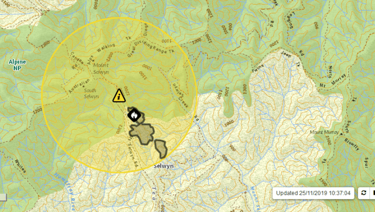
Mt Selwyn
There is also a fire in the Mt Selwyn, Wonnangatta and Tea Tree Range area, which is not yet under control.
Parts of the Alpine National Park and State Forest in the Tea Tree Range, Barry Mountains, Upper Buffalo and Upper Buckland Valleys will be closed from Sunday night at midnight including:
- Upper Buffalo Valley – closed south of Dandongadale (except local residents)
- Upper Rose River – restricted access
- Upper Buckland Valley – restricted access
- Australian Alps Walking Track – closed east of Speculation and west of Mt Murray Logging Road
- Cobbler Plateau – closed
- Mt Selwyn and the Tea Tree Range – closed
[BELOW: location of the Mt Selwyn fire, 25/11/2019]
Other areas
The Mount Bogong fires are among 13 burning in remote areas of forest in north east Victoria and other fires are located near Eskdale, Tallangatta Valley, Dandongadale, and Abbeyard.
DELWP says:
‘The remote locations of these fires are proving to be challenging for our crews and we fully expect them to burn for a number of weeks as firefighters work hard to contain them.
No communities are currently under threat, however, residents need to remain informed and monitor conditions.
More than 300 firefighters and Incident Management Team staff, aircraft and heavy plant and machinery continue to work on these fires’.
Much of the region is forecast to have a Very High Fire Danger Rating tomorrow, Monday 25 November, and a Total Fire Ban has been announced for the Northern Country with hot and windy conditions expected.
For road and track closures visit: www.traffic.vicroads.vic.gov.au or www.parkweb.vic.gov.au/
For the most up to date incident information visit: www.emergency.vic.gov.au


November 24, 2019 at 10:31 pm
Cam, we have to be ever mindful of what’s going on