
There have been significant fears raised in the environmental community about the two high country fires that are currently burning. One (the Matlock fire) has threatened to run south to the Baw Baw Plateau. It is now contained. The second one (called the Mt Margaret fire and marked on Emergency Victoria maps as NE of Licola) is not yet under control and moving into precious high country areas. UPDATE, March 6: there is a new fire – in the Wonnangatta Valley.
We appreciate the huge effort that has gone into containing the Matlock fire. Forest Fire Management Victoria (FFMV) crews have obviously worked hard on both these fires. But a situation is unfolding at present (monday March 3, 2025) which could see an ecological catastrophe happen in the coming week.
We will post updates here as there are changes to the conditions on the fires. Scroll down to find the latest.
The Matlock fire
(This is marked as ‘10Km S Of Matlock’ on Emergency Victoria maps).
There were fears that if this fire had traveled south it could have impacted on the snow gum woodlands on the Baw Baw Plateau. These represent the largest stronghold of middle aged snow gum in the state and are incredibly important from an ecological perspective as they will be a future refuge for old growth snow gum woodland if fire can be excluded.
There was a Snow Gum summit two held 2 weeks ago at Dinner Plain with lots of expert speakers in the field of fire and land management. Baw Baw National Park was identified as a crucial refugia now as it contains the last extensive relatively long unburnt Snow Gum woodland along with unburnt sub alpine peatlands and Alpine Ash in Victoria. It is crucial we keep fire out of Baw Baw National Park if possible.
UPDATE: 6 March
This fire is now contained, at a size of 321 ha, and crews still working on the fire ground.
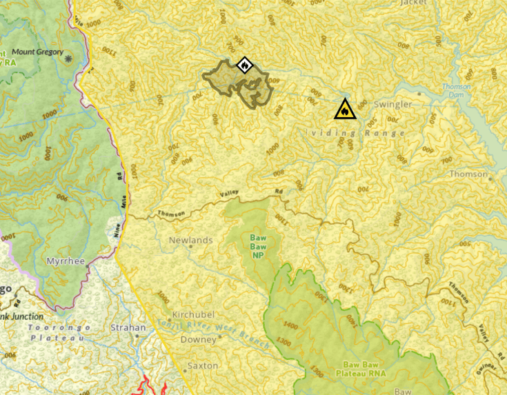
The Mt Margaret/ Licola fire
(This is called the ‘NE of Licola’ fire on Emergency VIC maps and called the ‘Macalister – Licola’ fire in the FFMV system).
Now that the Matlock fire is contained (that is it is no longer spreading, however it is still burning) the fire north east of Licola raises significant issues. The fire started early in the week of February 24. However in the last 24 hours it has grown in size – it is currently 4,248 ha. There is a large firefighting operation underway with around 120 staff, bulldozers and vehicles on scene. What is particularly distressing is that it has burnt north into higher alpine country which has been badly damaged by fires over that past two decades.
On social media, FFMV has noted that it has prepared Millers Hut for potential impact by wrapping it in Firezat wrap. If FFMV believes the hut, which is located on the Wellington Plains, could be impacted it is likely that the fire will have burnt:
- Through the area around Lake Tali Karng, which is highly significant to GunaiKurnai and contains old growth mid elevation forests. It is also a hugely important recreational location, which attracts thousands of bushwalkers each year, which in turn helps support economic activity in Licola
- Remnant old growth Alpine Ash above Tali Karng along Gillios Track. This area has been burnt previously with considerable loss of old trees. The remaining forest has great ecological significance given the ongoing loss of Alpine Ash forests across north eastern Victoria, and
- Across the Wellington Plains. The snow gum woodlands on the Wellington Plains have been impacted by multiple fires starting with the 1998 Caledonia River fires. Local surveying shows that another fire will impact on the young – and highly flammable – regrowth and potentially cause local ecological collapse of these systems at a large scale.
There are a number of fires burning across the state at present and FFMV resources are stretched. But it is deeply concerning that this fire has now grown to the point where it is probably beyond control. The likely ecological impacts on the Wellington Plains area if the Licola fire is not able to be contained soon will be enormous and likely lead to local ecological collapse.
UPDATE: March 17
After heavy rain on sunday 16th and a long campaign by ground and air crews, the fire has now been marked as ‘contained’, with a total size of 5,642 hectares.
UPDATE: 6 March
Incident controllers report that they are making progress and are slowing the growth of the fire, with sustained use of air resources. The priority areas of the fire control strategy are:
- to protect the Licola community
- to protect cultural values along the Wellington River, and
- to stop the northern spread of the fire into the high plains area. This area is a ‘fire exclusion’ zone on fire maps and fire managers are seeking to keep the fire out of the fire damaged snow gum woodlands on the Wellington Plains. This includes ‘Dead edging’ to stop movement of the fire: this is a term used to describe perimeter burning of an area in mild conditions prior to the arrival of the fire front. They are also dropping retardant and water on the dry ridgelines where safe to do so (and well away from water lines and streams).
They are also seeking to keep the fire from burning up Riggall Spur, which could bring the fire onto the Wellington Plains in the Spion Kopje area.
They also want to keep the fire out of the Carey catchment, where fire impacted alpine ash forests have been reseeded through the state government Ash Recovery program.
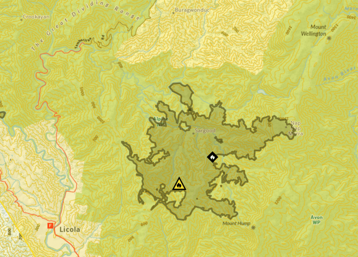
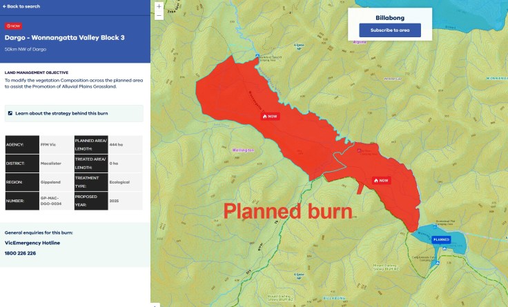
Wonnangatta Valley
This is a new start (5 March).
DEECA have confirmed that a planned burn has escaped. There were 2 planned burns happening there in previous days. These were listed as ‘ecological burns’, intended to keep grassy plains in the valley bottom open.
It is currently listed as Not Yet Under Control and 483 ha in size.
UPDATE: March 17
After heavy rain on sunday 16th, the fire has now been marked as ‘contained’, with a total size of 3,076 hectares.
What’s the solution?
In the immediate moment, FFMV need to put more ground crews and aircraft onto this fire.
We have urged the government to allocate additional resources to this fire to stop it moving north.
But the fact the fire got away in relatively mild conditions highlights a deep problem with how fires are fought on public land in Victoria: wild nature is often left while resources are directed at protecting human assets. While this is understandable it does highlight that we simply do not have enough career firefighters in the state to protect our national parks and other public lands.
Here are some obvious actions that should be conserved by state and federal governments:
- Victoria must continue to invest in expanding volunteer firefighting capacity – including innovative ideas that will allow urban based people to get involved in firefighting (details here)
- Victoria must continue to invest in state funded firefighting capacity within FFMV
- The federal government should finally establish a national remote area fire fighting team, as was recommended after the destructive 2016 fires in Tasmania (details here)
- And the federal government should continue to invest in Large Air Tankers (LATs), which are currently largely leased in from North America. At present we need 6 or 7 LATs each summer yet most of these are leased. Leasing will become more difficult as the USA requires more aircraft for longer periods. The Royal Commission inquiry that happened after Black Summer recommended that Australia invest in a ‘modest, Australian-based sovereign’ fleet of LATs and Very Large Air Tankers (VLATs). Details here.
- State and federal governments should continue to invest in early detection and rapid response systems to allow fire services to identify and respond to new start fires quickly.
These fires should be treated as the ecological disasters that they are. For instance, they could be given a state priority to allow the allocation of enough firefighting resources. Fire controllers should be obliged to act to protect fire sensitive communities like rainforest, alpine and mountain ash, snow gums and peatlands. There has previously been work done which looked at priortising and protecting peatlands from fire. This culminated in a fire work instruction to seek to prioritise the protection of peatlands and mitigate impacts in the event of fires starts that threaten peatlands. This approach should be set into law so that Incident Management Centres, where decisions are taken about where to apply firefighting resources, are obliged to priortise protecting ecological as well as human assets.
As we enter another warm and dry week, the clock is ticking on the Licola fire.


March 3, 2025 at 4:15 pm
Hi Cam. Identical issues to those in Tasmania, particularly the fires that have recently burnt Huon pine rainforest in Takayna. In these fires, fire-fighting has prioritised minor human infrastructure over ancient pines. This explicit policy has been emphasised multiple times in recent weeks in media reports, and there appears to be no interest in rectifying this twisted priority.
Fire burnt to within a few hundred meters of all 8 major pine groves in the Wilson/Harman catchment – the last remaining Huon pine river system that has not been logged. Of these, fire burnt to with 10m of 3 of the groves. There was no effective intervention to protect Huon pines until after the principal fire threat had passed. They were saved only by incredible luck, as a result of wind shifts and by the fall of night.