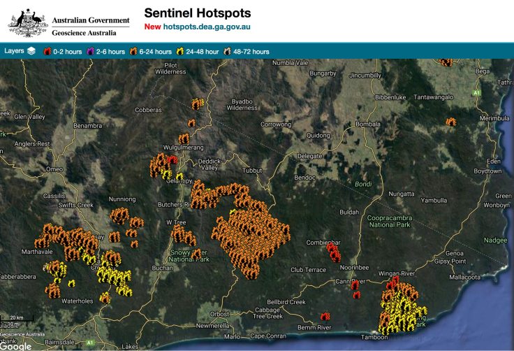
In late November, fires started in East Gippsland as a result of lightning strikes. As noted by Peter Gardner, these went on to become major blazes. On new year’s eve, lightning storms started fires across the Victorian mountains and fire season came to the Alps with a vengeance.
Since then, huge areas of the Victorian Alps and Snowy Mountains have burnt. As at January 14, many of these are still going and, of course, the key priority is containing them.
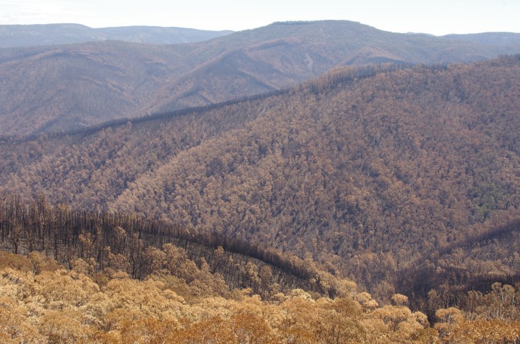
But once it’s all over, we will need to count the ecological cost of these fires. Some areas in the Alps have now burnt three times in about 15 years. There is no doubt that longer fire seasons, driven by climate change, are already impacting on mountain and foothill environments.
The short answer at this stage is that we just don’t know what the full ecological impacts of these fires will be.
The following is a fairly random collection of reports on local impacts of the fires on mountain areas. It focuses on ecological values and impacts. Of course, this does not mean that human and economic impacts don’t matter. The narrow focus here is simply to try and share some information about what the impacts will be on natural systems, as the other stories are already being told widely in mainstream media. It will be added to as areas are re-opened to the public. I would welcome your reports for inclusion: please email text and stories to cam.walker@foe.org.au
OVERVIEW
Victoria. We know that this summer’s fires will have a devastating impact on natural environments and the animals who rely on them. An initial report from the Victorian government found that in that state:
- “Almost all” eastern ground parrots’ Victorian habitat has been destroyed
- 40 per cent of the Victorian habitats of the sooty owl, diamond python, long-footed potoroo, long-nosed bandicoot and brush-tailed rock-wallaby have already been wiped out.
- An estimated 25 per cent of the sooty owl population has been killed.
- The East Gippsland galaxias, a native Australian fish, has had 100 per cent of its potential habitat burnt, while more than 70 per cent of the Gippsland water dragon’s habitat has been incinerated.
- 31 per cent of the state’s rainforests had already gone up in flames, as well as 24 per cent of wet or damp forests, and 34 per cent of lowland forests
Leading conservation biologist Professor David Lindenmayer said it would take more than 100 years for wet and damp forests to recover from the ferocity of this season’s fires.
And this is what is known about the fires in NSW:
- 5.128 million hectares (6.4%) of NSW has been affected by the wildfires. The severity of fire within this total area varies.
- More than 35% of the national park estate has been impacted. In key bioregions, the figure is well over 40%.
- More than 80% of the Greater Blue Mountains World Heritage Area and 54% of the Gondwana Rainforests World Heritage Area have been affected by fire.
- The most affected ecosystems are rainforests (35% of their statewide extent), wet sclerophyll forests (41%) and heathlands (53%).
- More than 60 threatened fauna species have been affected by the fires, including 32 species for which 30% or more of all recorded locations occur in the burn areas.
[This was last updated on FEB 17].
VICTORIA
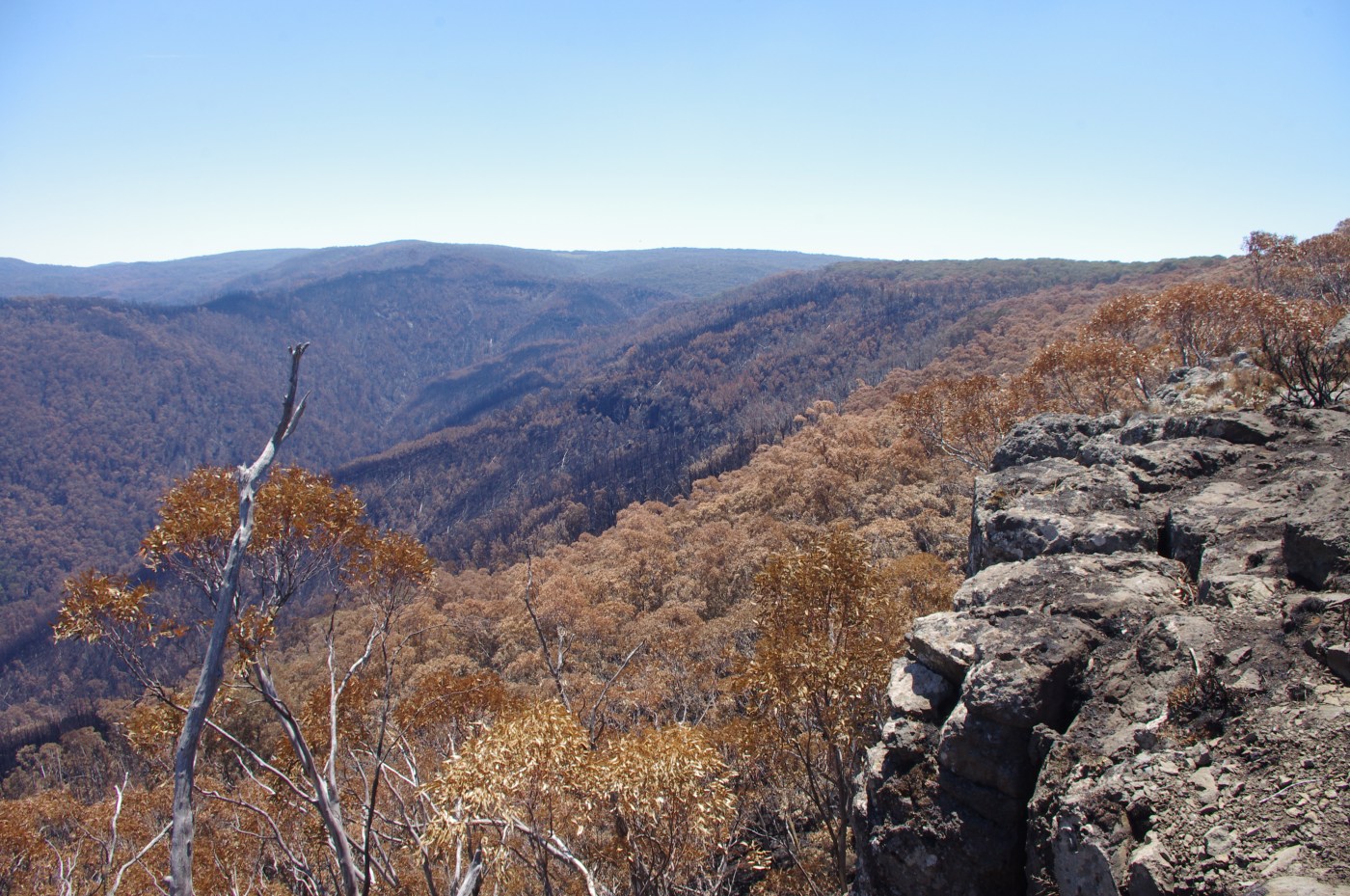
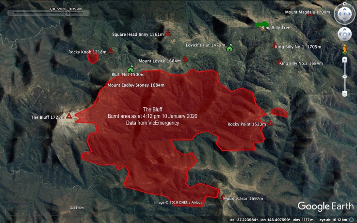
The Bluff, Victoria.
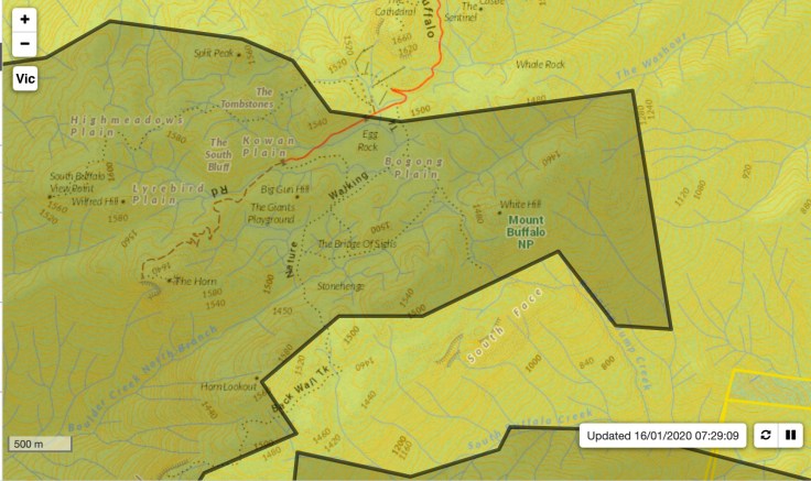
Several fires started in The Bluff/ Mt Stirling area on new year’s eve as a result of lightning strikes. The remote location (and large number of other fires) made it difficult to contain. The Bluff Creek fire has now grown to be more than 3,759.00hectares in size and has burnt along some the crest of the range that runs between Mt Magdala and The Bluff. According to maps released through Emergency Victoria, it appears that the fire has not burnt the older Alpine Ash forests near Lovicks Hut or most of the older snow gums along the eastern end of the range. However, it has burnt out much of the alpine zone on Mt Eadley Stoney and The Bluff itself.
The fire is not yet listed as being Under Control.
The Tabletop fire
Mt Tabletop is just south of JB Plain in the Alps, between the Mt Hotham ski resort and the village of Dinner Plain. There is a scientific Reference Area there which has been partly burnt. It has now grown to more than 10,000 hectares and has burnt large areas of snow gum forests. Some of these fires have burnt very hot and hence have been very destructive.
Having been involved in some of the fire fighting efforts at Tabletop, it was evident to me that many of the trees burnt in 2003, which are now falling over, are leading to very hot localised surface fires forming where these log piles catch fire. This is a landscape wide issue.
It is now starting to merge with the larger Shannonvale/ Mt Battery fire (28,000 ha), which has burnt considerable sections of the south eastern side of the Bogong High Plains. It has burnt almost as far as Mt Cope on the southern end of the High Plains and through much of the Cobungra River valley.
(By February, this fire had merged with others and burnt more than 40,000 hectares).
The Abbeyard fire
This also started as a result of lightning strike. It has merged with an enormous fire (35,000 ha) south of Mt Hotham, which has burnt sections of the Tea Tree Range and come close to The Twins. The Abbeyard fire is 70,000 ha in size and has been threatening communities and towns. It has burnt large sections of the northern foothills of the Alps and up onto the southern edge of the Buffalo Plateau. Alpine Ash forests on Buffalo were devastated in previous fires.
Far East Gippsland
It appears that most of the famed Kuark forest has not burnt (or has possibly been ‘burnt lightly’ according to reports from the field), and it appears that the Errinundra Plateau has been spared any major fires. It appears that the Goolengook rainforest has been partially burnt and the rainforest at Martins Creek has been badly burnt. Most of Mt Ellery and the Goongerah area were hit hard. Large sections of the Snowy River National Park have been burnt.
In late January, a fuel reduction burn on the NSW/ VIC border escaped and started to threaten the fringes of the Errinundra Plateau. This area contains the largest patch of Cool Temperate Rainforest on mainland Australia.
On FEB 3, Friends of Errinundra reported that:
“Aerial survey of the fire on Errinundra shows that the Big Rainforest site on the Coast Range has had some fire at it’s edge, but so far is relatively untouched. The Coast Range Rainforest is the largest patch of Cool Temperate Rainforest on main land Australia. Other observations are that Rainforest gullies which hopefully includes First Creek Falls seem to be ok”.
Murray Valley headwaters
An enormous fire has burnt out large sections of public and private land, including the Burrowa Pine National Park near the Upper Murray and into the Alps as far as Mt Pinnibar.
NEW SOUTH WALES
The Snowy Mountains
Several now connected fires have burnt much of the northern Snowy Mountains, including the Cabramurra area (details via the Rural Fire Service website).
Additionally, some sections of the southern Main Range, mainly on the western fall from the mountains and around Dead Horse Gap have been burnt.
The fires in the area have joined into a ‘mega blaze’ south of the Snowy Mountains, following another massive fire merger nearby earlier in the week. An area totalling nearly 600,000 hectares is now ablaze (source: BBC).
Of what is called ‘Alpine Complex’ vegetation on NSW, 16,312 ha of the total 130,780 of alpine ecosystems (or about 12%) have been burnt (as at Jan 10).
Please note that Kosciuszko National Park is closed until further notice.
Western slopes of the Snowy Mountains
Gavin Phillips, field botanist for the Royal Botanic Gardens, based at Mount Annan reports that the fires near Tumbarumba burnt ‘lots of the subalpine plains and montane forest, quite hot in some places’.
The following assessment comes from Dr. Graeme L. Worboys and was published on the Reclaim Kosci website.
The fires burnt through alpine ash forests regenerating from similarly severe fires in 2003. These grand species propagate through seed and 17 years may not be enough time for the young, regenerating trees to produce new seed. Some remnant older alpine ash would also have been burnt and their associated hollows providing critical habitat for native birds and mammals would have been lost. Frequent fire, higher temperatures and regular droughts were transforming mountain ecosystems. At higher altitudes on the Kiandra plains, fires impacted regenerating snowgums. This species is critical for enhancing water yield for the Murray and Murrumbidgee catchments and too frequent fire would see the loss of these subalpine trees. Native grassland, wetlands and stream side heath were also burnt. Some small grass and heath patches were left unburnt on the Kiandra plain.
Kosciuszko’s native alpine animals and their habitats were impacted by the fires. A thick vegetation cover of subalpine heath and tussock grasses (for example) provided habitat and protection for the endangered Mastacomys, the magnificent Australian broad-toothed rat. The 2020 fires removed such protective cover in many parts of Kosciuszko. It also burnt vegetation on the boulder fields near Happy Jacks including the mountain plum pine, a food source of the resident mountain pygmy possums. Kangaroos, wallabies, wombats, echidna’s, possums, bats, birds, snakes, lizards, skinks, frogs, insects, and crayfish are some of the sub-alpine wildlife affected by these fires. Tragically many of these different animals will have been killed. Native fish and platypus in streams will also be impacted by post fire run-off and erosion of ash and burnt soil contaminants into the streams. Grass for red-necked wallabies and wombats in the subalpine burnt areas will be scant, with unburnt patches and new green shoots being important for these animals.
ACT
The fires this year in Namadgi National Park burned with an intensity veteran firefighters “had never seen” before.

The Orroral Valley bushfire, which spanned over 80,000 hectares and saw the ACT enter a state of emergency, has become the territory’s worst ever environmental disaster, destroying 80 per cent of Namadgi.
Brett McNamara has spent three decades as a manager with ACT Parks, and the Namadgi National Park has been not just his workplace, but his passion, and his source of spiritual replenishment.
For the veteran parks ranger to have to watch it burn — for the second time in his career — was soul-crushing. “What we have lost to some extent is the ecological integrity of an area that all of us love”.
Environment Minister Mick Gentleman called the Orroral Valley fire an “ecological disaster”.
The big unknown though, is how often Namadgi can sustain such high intensity burns.
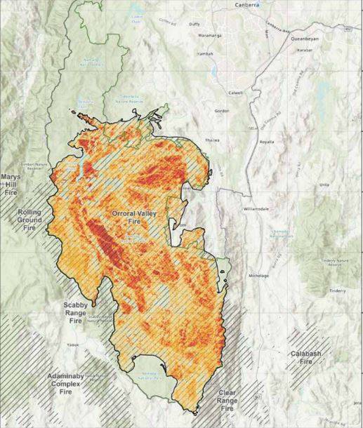
Above: the scale of the fire in Namadgi national park.
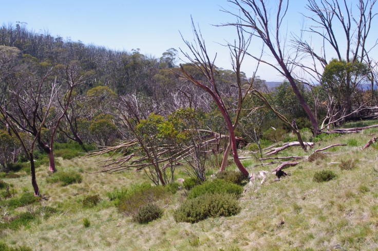
The impacts of previous fires

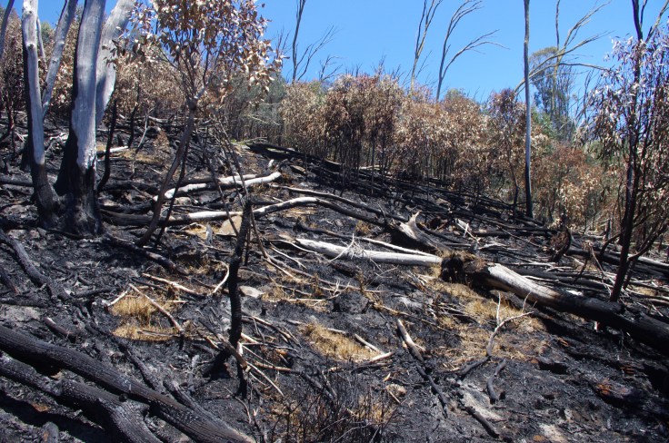
As noted above, some areas in the Alps have now burnt three times in about 15 years. This has resulted in areas with huge volumes of dead standing timber and vigorous regrowth, which is highly flammable. In some areas, the dead standing timber is now falling over, creating log piles in the forest. Once fire moves into these areas and takes hold, it burns hot. It also means that these log piles can burn slowly for many days and be fanned by winds at a later date, keeping the fires active long after the original burn.
In the Hotham area, as one example, the trees killed in the 2003 fires are now starting to fall in large numbers. This is a landscape scale problem, which cannot by dealt with through thinning or other human intervention. It is simply part of the fire fighting reality now.
The physical impacts of fire fighting
Fighting fires in remote and hilly terrain requires the use of fire breaks. Because of the size of these fires, many can only be contained, not actually suppressed, so fire breaks are an essential part of fire fighting efforts.
Additionally, fire retardants are used, where needed and planes are available. The Sydney Morning Herald reports that one of the main fire retardants used by the NSW Rural Fire Service is Phos-Chek, known for its characteristic red pigment. To date there has been little research into possible ecological effects of Phos-chek on Australian ecosystems. In order to reduce possible impacts, fire authorities seek to avoid applying Phos-Chek in close proximity to waterways.


January 14, 2020 at 5:51 pm
Cam, we need to have a NATIONAL POLICY on climate change including water security, food security and it needs to be scientifically based and with the knowledge or elders who know our country. When that ever happen.
Regards, Maggie
________________________________
January 17, 2020 at 7:57 pm
And we need to start digging contour based swales to retain rain event water for deep rain penetration and wetter landscape. Also for faster organic matter decomposition rates for less ground fuel and healthier soils. At the moment most rainwater just rushes down into rivers causing erosion, soil loss and flooding events. What do you think? It will be huge huge gigantic amounts of proactive work and polluters must be made to pay for it. People have regreened deserts with these methods so we know they work by storing maximum amounts of rainwater in the soils. It can and does shift weather patterns and the drying cycle can be minimised and in time reversed. Any thoughts?