
It was the end of day four on our 160 kilometre ski tour from the resort town of Aspen to Vail, in central Colorado. We’d had a brutal day, with an early start at 11,300 feet, a long descent off the edge of the Continental Divide, endless touring through deep fresh snow, and a final punishing two hour climb to Jackal hut. But tomorrow was the big day.
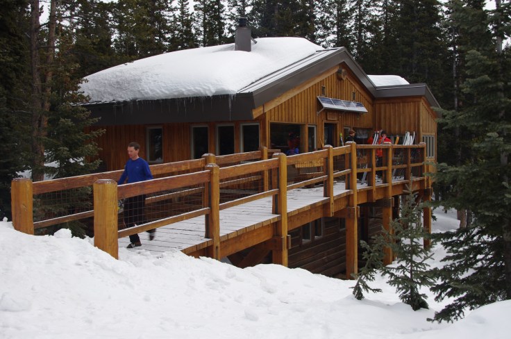
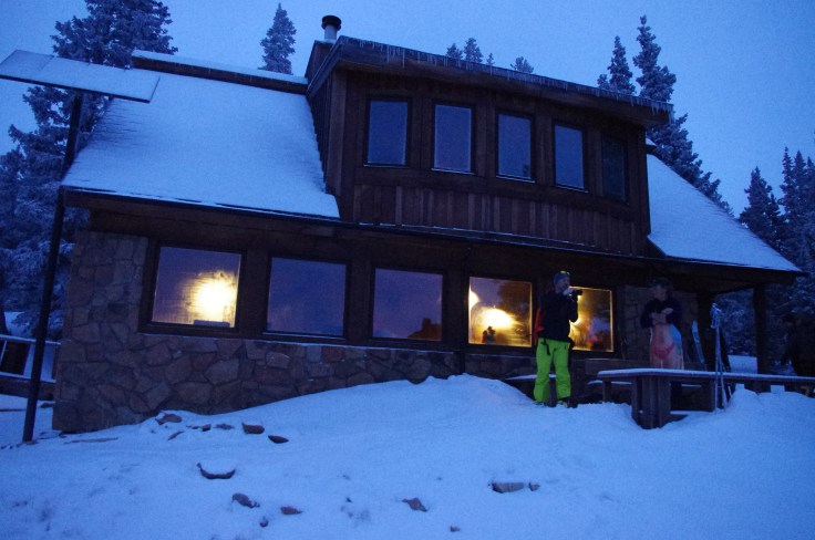
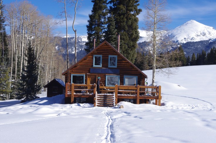
Perched on the edge of a meadow with jaw dropping views to Mt Elbert, the highest of Colorado’s 14K peaks, Jackal is a solid log cabin with a big front deck that is owned by the 10th Mountain Division Huts Association. On day five we left the hut just after dawn, shuffling through a dark spruce forest onto a long ridge that climbed towards the 12,000 foot mark. The plan was to take a high route over the mountains to our next destination – Shrine Mountain – rather than a lower and more complex trail below the treeline. I’d been struggling with the downhill sections, and was dreading the descent off the other side.
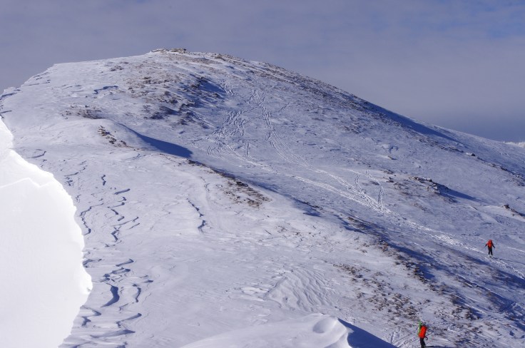
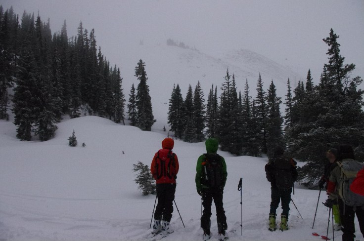
We climbed at a steady pace, into crazy winds as spindrift hammered our faces and whipped around us in sheets of white. It was too cold to stop, but brilliant sunlight and the thin air of the mountains gave a surreal edge to the ascent. We climbed Pearl Peak, then descended down an icy slope, side slipping to a narrow col, before a final slog took us towards the top of the Elk Peak range. As we climbed the final section, I felt like I was on the Razorback Ridge near Feathertop. It felt like home. Just on a grander scale.
Topping out on the summit ridge, the slopes beyond came into view. Basins and a long traverse lead down to Searle Pass. My mind turned to the Main Range of the Snowies. My fears tumbled away, snatched by the icy wind, and some words scrolled across my mind’s eye: I Can Do This. It was my Breakthrough day.
We dropped down into a mix of classic Colorado powder, but mostly crusty snow and icy sheets. I thanked the guides for organising the ‘Australian snow’ as we bashed through wind affected crud.
We were on the Benedict 100, an annual six day ski that honours Fritz Benedict, who established the 10th Mountain Division hut system in Central Colorado. The 10th Mountain network is the largest in North America, owning or booking more than 20 huts, and is modelled on the European idea of hut to hut skiing. Its name also reflects the tradition of the 10th Mountain Division of the US Army, who trained in the area before fighting in the European Alps in World War Two.
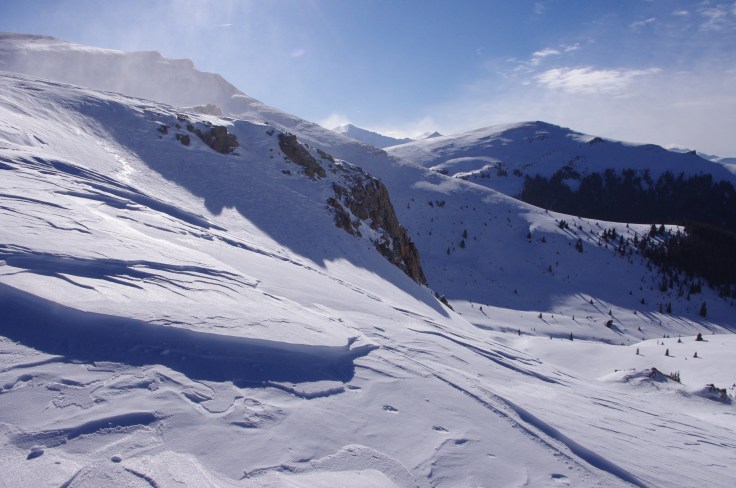
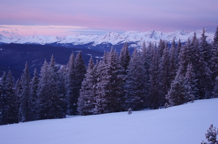
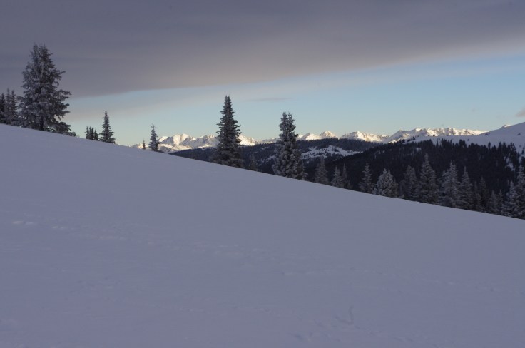
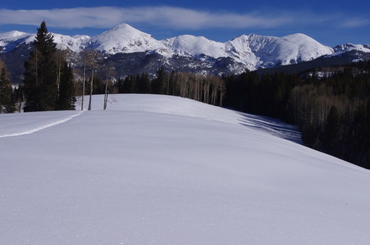
I had long dreamed of long distance backcountry skiing through the Rocky Mountains. What I found in Central Colorado was beyond my most hopeful expectations. The Central Rockies are an incredible place, and well suited to an Australian skier looking for some larger terrain and grander mountains. If you’re looking for steep terrain, there are countless opportunities. Yet there are also endless touring options suitable for the average competent XC skier, especially if you’re looking for multi day trips. For the most part it is easily accessible, being bounded by three main road systems. The treeline tends to sit above 10,000 feet, meaning the journey up from the trail heads in the valley bottoms tend to include several thousand feet of vertical. Beyond the treeline, alpine ridges stretch up above 13,000 feet, snaking as far as the eye can see. Many of Colorado’s highest peaks are in this area. It also offers the luxury of hut to hut skiing, therefore avoiding the need for camping. It has a mix of forest roads, ski trails and wilderness, so you can make the navigation as easy or hard as you like. The only downside are the snowmobiles that track out large sections of the backcountry. However, once you’re out on the 10th Mountain Trails or in the massive Holy Cross or Fryingpan wilderness areas its rare to see another group and snowmobiles are banned in large sections of the mountains.

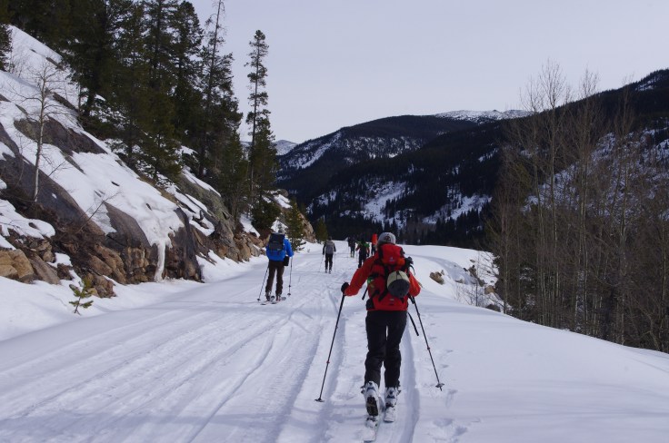
In 2015, the Bene 100 was organised by Paragon Guides. We had a team of eleven punters and three guides as we skinned up out of the Aspen Valley just after dawn in late January. Light climbed slowly across the surrounding hills as we navigated meadows and bare aspen forests. Then up into darker spruce forests and morning tea at one of the 10th mountain huts. The four residents were surprised to see us there so early, and we soon pushed on to a long traverse and descent into Woody Creek, and an equally long haul up along the Spruce Creek Drainage, weaving our way through an open forest of old Spruce and sub Alpine Fir. We were on the edge of the Hunter Fryingpan wilderness, a massive wild area where blazes on trees are the only markers to guide the way. Blazes (and blue trail markers in the non wilderness areas) are somewhat aspirational, so you need good navigation skills, and attention to the map is a necessity. By late afternoon, we were getting close to Margy’s hut. The head guide, Will, cheerfully informed us that we faced ‘the hardest mile in the hut system’ before we would see the welcome sight of a sturdy log cabin nestled into a hillside just before dark.
Two people bailed after the first day. The second day was another long haul, starting with a steep descent through fantastic snow and tight tree skiing. We emerged onto an open plain, crossed a stream, and descended into the Fryingpan drainage and a long cross country trek past some summer cabins and hard climb to a Forest Service Road. We were settling into the pace of a large group on a long ski, finding our particular rhythm and testing our endurance. Some were up front, others pacing themselves, with the guides navigating often tricky terrain. In spite of the summer road network, this is certainly a winter wilderness, and many of the trails are simply walking tracks that are buried under several metres of snow. The landscape became more dramatic as we headed up valley, but Road 505 was hard and icy, and we made slow time towards the impressive mountain headwall where the Fryingpan ended.
After we left the road at an obscure trail junction, a final series of switchbacks climbed steeply up through the woods. The slope was south facing and sun baked. In the flat afternoon conditions it was glassy, and each of us dropped into our own rhythm as we concentrated on not slipping as we inched our way upwards. ‘This is the hardest two miles in the hut system’ said the ever cheerful Will. Two thousand vertical feet later, as the ridge began to ease back and the last of the light drained from a translucent sky, I shuffled downhill through shin deep powder, peering for some sign of the hut. Betty Bear has a long access ramp and downstairs bunkroom and I knew there would be a fire, beer, food and water. Never did a log cabin look so good.
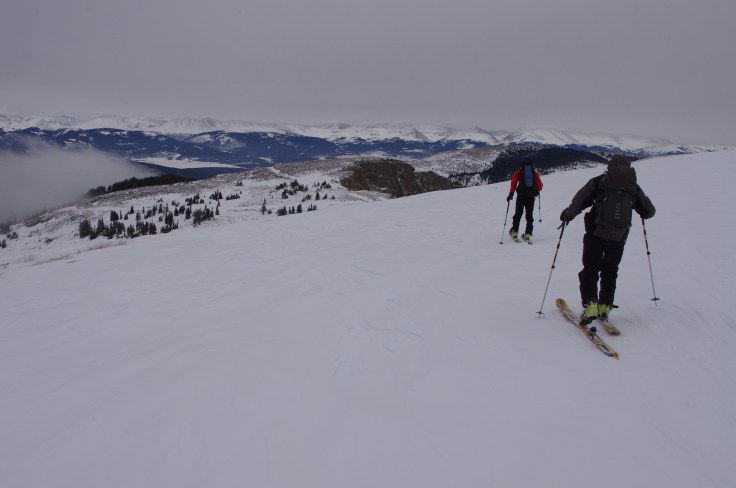
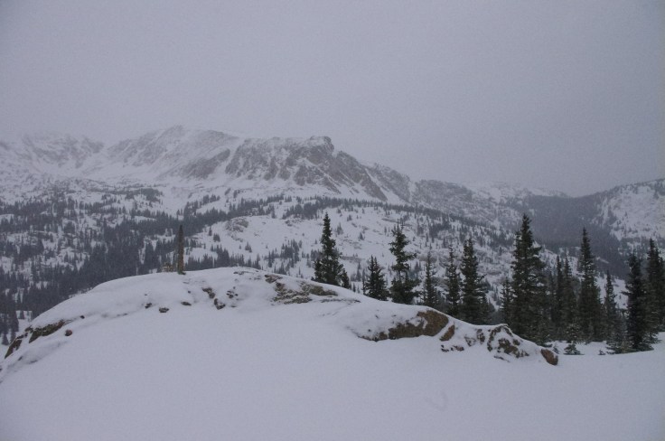
Perhaps the highlight in what was a generally spectacular trip was the climb the next day across the Continental Divide. The Divide separates water flowing into the Atlantic and Pacific Ocean basins.
From Betty Bear hut, the route followed shallow valleys up to Hagerman Pass, at 12,000 feet. The land became increasingly alpine in feel as the spruce forests thinned out. Hagerman is a broad divide between the Pacific and Atlantic Oceans and must be a mellow place in mid summer. A 2WD dirt road passes through the area. But on a chilly winter’s day, with the sun low on the southern horizon, walls of impressive mountains on both sides and the deep trench of the Leadville Valley beyond, it’s a place for a quick group pic before pushing on.
From the Pass it’s a steep descent into the Glacier Creek drainage. This was too steep for me with a heavy pack and I struggled into a deep valley, traversing and step kicking my way down. Probably two out of three people on the trip were on alpine touring (AT) setups, and they quickly disappeared into the trees. I saw one person fall and disappear into the snow, to be stuck, like a turtle, on their back. Tonnes of dry powder had accumulated on the slopes and it really was magical terrain, despite my personal struggle to get down with my dignity intact. I had trained hard for this trip, and each time I had strained up some rocky trail on my MTB back in Castlemaine, I’d thought about how it was all ‘money in the bank’ in terms of fitness.
After the descent of Glacier Creek and quick lunch, the next 90 minutes was a solid climb onto the southern slopes of Galena Mountain. I dropped to the back of the group and it felt like I had burnt all that credit I’d be building. Slow rest steps, which are really just a climbers rest step on skis, got me up the hill – eventually. I had forgotten the whole of body misery that comes with climbing at altitude with a heavy pack, and had a realisation about why so many people go to the beach for their holidays. But each step meant the view opened out, and even in my weary state, my spirit was soaring as we climbed ever higher above Turquoise Lake.
By late afternoon, we were on the final climb to Uncle Bud’s hut, my favourite in the network. I had spent four days here with Paragon Guides to acclimatise and get used to the terrain and its lounge room views to Mt Elbert and appropriately named Mt Massive, neatly framed by dark and elegant Spruce trees, were spectacular. The best beer of my life had been drunk while sitting on the front deck looking at the mountains as the sun went down, and I was glad to be back.
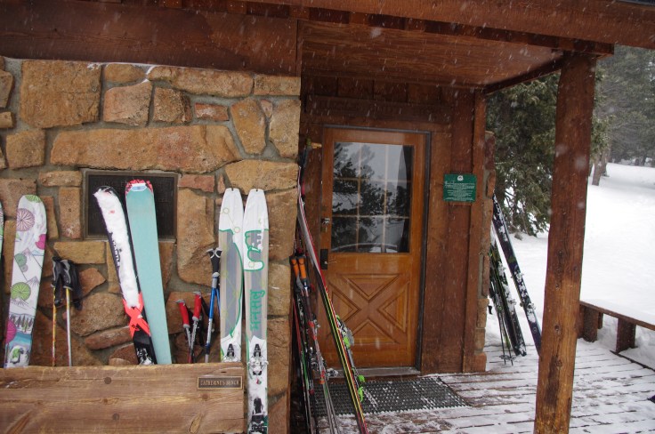
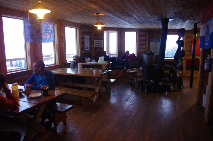
Because the days are long on the Bene 100, different groups help organise hut hosts each night. Life in the backcountry revolves around the endless need to dig snow, melt snow, maintain the fire, and drink water. So having water available when we arrived at the huts was a huge bonus. We were treated to great food, and like kids at a birthday party, would pass through several Peaks and Crashes as the evening wore on: the initial food and alcohol rush, then exhaustion, then the dinner high, and then people dozing off on the couch. A big night out meant staying up til 8.30. The huts generally hold 16 people so we were squeezed in, happily chatting, and oblivious to the odour of 32 ski boots steaming away by the pot belly. The huts were packed with skins, clothing and equipment and looked like there had been an explosion in a gear shop.
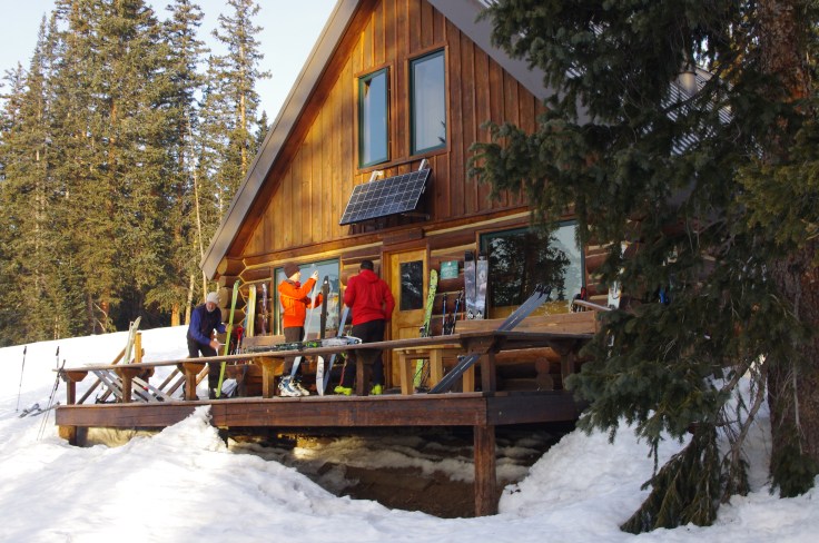
At Uncle Bud’s the hut hosts were a lovely couple, Ted and Carol, who had worked for years for the 10thMountain Hut Association. They were the invisible team who helped keep the system going – they cut the firewood, maintained the solar panels that lit the huts, and did the repairs. They lived above 10,000 feet and radiated a calm love for the mountains. They had painted a ‘welcome Benedict skiers’ banner and even had (plastic) flowers on the tables. We swooped on the snacks they had laid out like wolves on prey and revelled in the luxury of a day that finished before sunset.
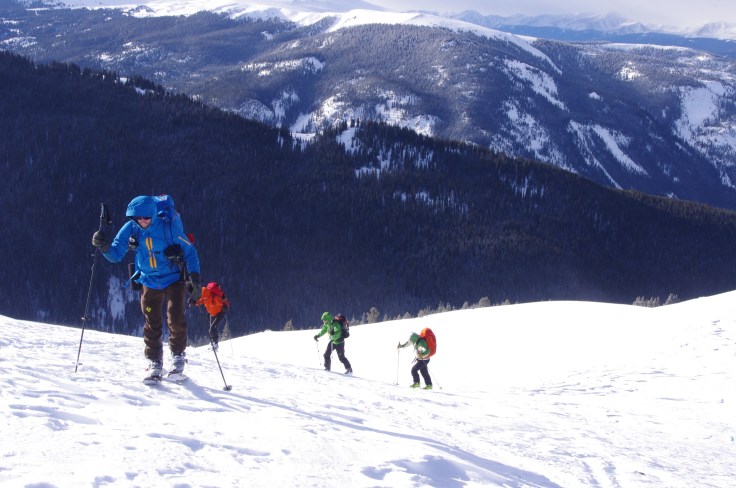
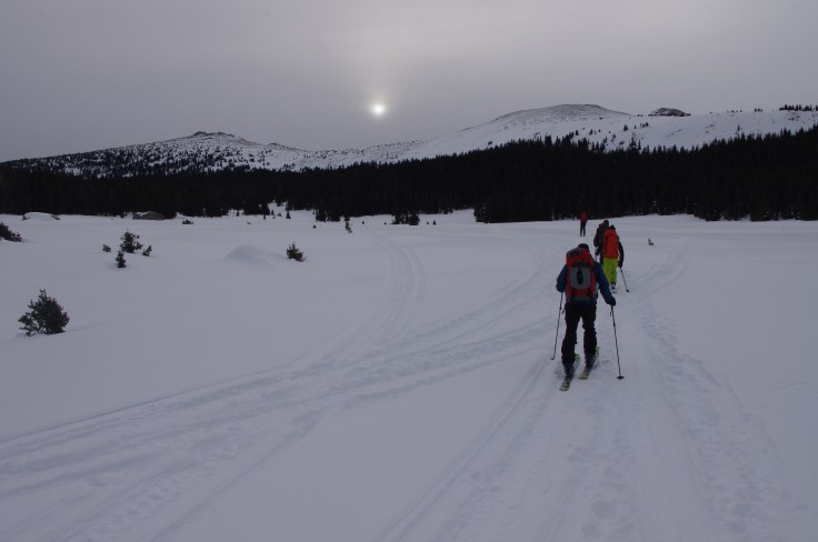
Each morning would start with a briefing from the head guide Will. He would sketch out the route, we would do a beacon check, and then head out, usually soon after dawn. The days were diverse as we climbed and skied something like 18,000 vertical feet, crossed the Continental Divide and the major drainage of the Mitchell River before climbing a final range to Jackal hut (‘the longest three miles in the system’, said Will with his usual smile).
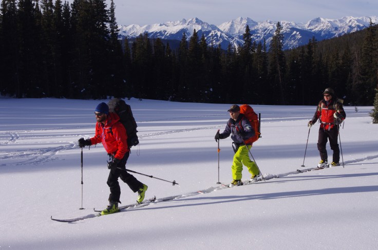
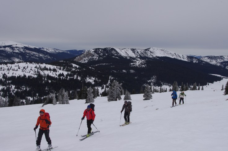
The remaining nine skiers were diverse. A couple from England who were into triathlons. A 71 year old retired oil worker who chewed through the miles without complaint, a nurse from Upstate New York, a media professional from Boulder, a public servant from Canberra. The three guides did the navigation, having scoped sections of the route in recent weeks, to make sure each part would ‘go’ in the conditions we had. When the snow started to bucket down on the day four marathon, Kurt the bulldozer broke trail for hours. Rochelle, a tele skier and all round fixer of broken things and damaged feet, did some of the trickiest route finding. Our cheerful leader Will was always circumspect about how far we had to go, but tried out his jokes, and charmed us into having a good time, no matter the conditions.
Having spent most of my skiing life in Australia, there were so many immediate lessons to be learnt: putting one skin on at a time while balancing on the other ski so as not to disappear into waist deep snow being one of the first. Half kick turns to get out of steep and nasty descents. The art of climbing *up* and out of powder after a fall. The need to keep your puffy jacket handy for those quick stops, and the dangers of quickly frozen fingers. Colorado air is dry so you need to drink more than normal. Sugar snow is bottomless, wind crust is nasty. But Colorado powder is something else. On the last day – day six – after climbing onto high ridges along a trail called the Commando Run, we snuck under the ‘keep out/ backcountry closed’ signage and into the Vail resort. On a high, wind blasted hill, we tore off our skins one last time and dropped into a foot of fresh powder. Despite heavy packs and trashed feet we had that perfect sensation of weightlessness and we did magic turns as we started the kilometre long vertical descent to Vail, a celebration, and one last picture together.
The other big difference to touring in Australia is the elevation. All the huts on the Benedict trip sit above 11,000 feet, and most in the hut system are higher than 10,000. Above this height, most people seem to have some difficulty sleeping, at least until they aclimatise. On an earlier trip to Uncle Bud’s hut, my jetlag had morphed into altitude lag. While some people take medication to avoid altitude sickness, I suffered through two nights and then came good on the third day.
A week later, after the Bene 100 team had scattered, I was on a steep hillside, kicking steps to a highpoint on Avalanche Peak. It was the last day of a solo trip to Harry Gates hut. An 18 kilometre ski in, and a test day of skiing the north facing slopes of Burnt Mountain lead me to an attempt on Avalanche Peak.
A long approach via meadows through Tellurium Park lead to a slow, convoluted ascent through tight and dark Spruce forest before I finally emerged at treeline. A snow hare did its routine of not making eye contact before bolting away. The main face of Avalanche loomed above me. Lacking a partner, my avalanche beacon was back at the hut, so I dug a trench and sussed out the snow. I knew there was a deep weakness in the snowpack from a sunny dry period in late November. But the snow looked perfect. I climbed steadily on a firm base that reminded me of home, and my thoughts drifted to a walk out I had done the previous winter from the Dargo Bowl at Mt Hotham, lugging my daughter’s splitboard. After three weeks of skiing I felt in good shape and confident about this one last objective. When I reached the highest point that I dared to climb to, I turned slowly to scan an amazing scene. The linked meadows of Burnt Mountain with their north facing powder slopes. Crooked Creek Pass and an endless mosaic of bare aspen and dark Spruce forests. The lake below, where John Denver had once owned land. The spectacular Maroon Bell Range and the mountains around the Aspen resort. Mt Massive, glimpsed from the west rather than the more familiar east side. It felt both familiar and exotic and ridiculously beautiful.
Afterwards, when talking about the trip, I’d tell people that I hadn’t cried so much since my children were born. Sometimes from exhaustion, occasionally from fear. But mostly from sheer joy.
On Avalanche Peak I started my turns, my confidence built, arcing wider, facing the fall line. A few moments of sheer grace and beauty, of weightlessness, and I was back in the trees, and the start of the long journey towards home.
LOGISTICS
Access
The Central Rocky Mountains can be defined as the area between the ski resorts of Aspen and Vail and the Front Range (the eastern fall of the Rockies) and is well serviced with a range of road networks, especially the I70 interstate that travels east to west from Denver. There are regular flights to Denver (and to local airports such as Eagle/ Vail) as well as a number of shuttle services that run from Denver International Airport.
There are dozens of trail heads, generally on lower roads that allow year round access. There are a number of options to organise shuttle services to trailheads, including Paragon Guides, which is based in Edwards.
The routes
With almost limitless alpine terrain, there are any number of trip options, including single hut trips (where you ski in from a trail head and base yourself at a single hut, using it as a base camp for day trips) or ‘through trips’. A classic first trip would be the West Lake Creek trailhead to Polar Star hut, then to Harry Gates and out to the trailhead at Montgomery Flats on the Fryingpan River.
10th Mountain Division Huts Association
Ten Mountain own or book more than 20 huts in central Colorado. The cost is very reasonable (less than $AUS40 a night) and the huts have stove for heating and melting snow, a kitchen with gas burners, mattresses and pillows. You just need to bring personal gear, food and sleeping bags.
They get booked up very quickly, so its worth planning well ahead. The 10th Mountain website allows you to check on bed availability and has an online booking system. The huts are beautiful log cabins, generally with communal sleeping areas, so take your earplugs, be neat, and leave the hut clean for the next people. Members get to book early so it’s well worth joining.
There are a number of excellent guides to the hut system. I would recommend Warren Ohlrich’s excellent guidebook the 10th Mountain Hut Guide.
Avalanches and sled necks
Colorado is notorious for its dangerous snow pack and high incidence of avalanches, and over the past 45 years more people have died in that state than any other in the USA.
If you’re unfamiliar with reading avalanche terrain, I would strongly suggest you take an avalanche course. Check here to find one in the area you’ll be visiting. http://avtraining.org/
The thing to understand is that in central Colorado there are lots of routes that will take you through safe terrain, with little or no avalanche risk. The 10th Mountain hut website and ski notes like Lou Dawson’s Wildsnow blog are invaluable for researching safe routes. https://www.wildsnow.com/
Most longer and ‘through’ trips will have some level of risk, so its imperative you carry, and know how to use, an avalanche beacon and rescue gear.
I would recommend doing a guided trip as your introduction to the region. Companies like Paragon Guides in Edwards offer hut based trips and you’ll learn about the snow conditions and safe touring.
One problem with being on the Forest Service roads will be the large number of snowmobilers that may be in the area. Apart from the nuisance factor, sleds will track up many of the roads and trails, making them unpleasant to ski on after a freeze. Again, it’s worth researching carefully to avoid the areas most popular with snowmobilers. While some users are ‘slednecks’, the majority will follow the agreed protocols: skiers should step off the road and snowmobiles should slow down as they pass each other.


April 5, 2020 at 5:12 pm
Hi Camm good on you Mate you are a devil for puishment save yourself yup this winter could still be partially on
Sent from Mail for Windows 10
May 23, 2024 at 4:22 pm
A good story and write-up about the trip and the area. I’ve skied many mountainous areas around the world, but Colorado is the place I’ve gone back to many times. (The former Canberra Public Servant referred to in the article).