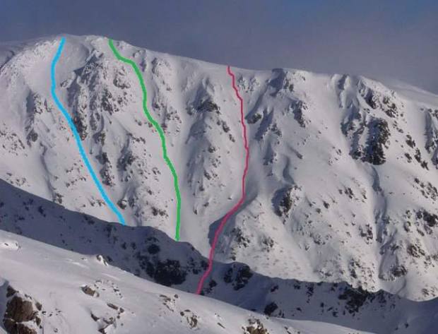
This is a great resource: the ‘gnarliest runs in Oz’, from the Huck & Dyno website (in two parts – Victoria and the Main Range in NSW).
The NSW feature has all the obvious things, and Victoria includes excellent coverage of places like Mt Buller, Feathertop and Bogong, and also some gems which are off the beaten track, like Mt Howitt.
A few years ago I put a lot of effort into expanding the ski wiki posts on backcountry skiing in Australia (mostly the VIC and TAS sections) but a big failure with this is the lack of images. In contrast to my effort, James and Sam, who are behind Huck & Dyno, have some gorgeous pictures of the mountains and general terrain, plus many of the actual runs. Visually beautiful.
I like their intro:
When you get down to it, Australia is the flattest driest continent on Earth. By definition, the skiing here is the worst in the world. … So it’s easy to write the place off as a land of sunburnt sweeping plains. Or, if you’re a skier, patchy cover, ice and crud, short shallow runs and snowmaking.
Even the highest mountain, good old Kosciuszko, is a hill with a road to the top… The very first time I ever went XC skiing, we made it to the top! Snowboarders were drinking beer up there! Fun for the whole family!
The enthusiastic might even bother to look over at the ‘Main Range’, hoping to see a craggier peak. But nope, Mount Townsend and Northcote and Lee all look pretty tame over there.
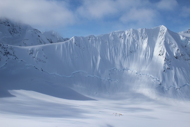
But then one day you’ll bother to climb the second highest peak, Mount Townsend, and have a look from the top of there and, HOLY CRAP, there it is…
So begins our investigation into the gnarliest lines in Oz.
With winter finally bearing down on us, I hope this inspires you. Get out there and enjoy!
The following article comes from The Age, journalists are Jason Dowling and Tom Arup.
Check here for the response from the Victorian National Parks Association. Check here for the VNPA Hands off our Parks page.
The Napthine government has introduced sweeping changes to Victoria’s national parks allowing for 99-year private leases – in the same week Canberra is considering expanding its powers over the parks.
The state changes mean the historic Point Nepean Quarantine Station is in effect up for sale, according to activist Kate Baillieu.
The commercial real estate section of The Saturday Age carried an advertisement from real estate agents Jones Lang LaSalle to lease the Quarantine Station. The government has also asked for expressions of interest for private development of the 17-hectare site.
Matt Ruchel, executive director of the Victorian National Parks Association, said the new 99-year leases that will apply in all of Victoria’s national parks, including Wilsons Promontory, were deeply concerning. ”National parks are primarily for conservation, not development,” he said.
Environment Minister Ryan Smith said the 99-year leases would ”give investors greater certainty and a stronger incentive to develop innovative, high-quality proposals in our national parks”.
A spokesman for Mr Ryan said there would be exclusion zones where development would not be allowed in national parks.
In Canberra, the federal government is considering expanding its powers over national parks in response to plans by Coalition-led states to allow cattle grazing, shooting and logging in protected areas.
Environment Minister Tony Burke met as recently as Wednesday with conservation groups who want him to broaden his oversight over parks before the election.
The Australian Conservation Foundation and the Wilderness Society wants a ”trigger” to be legislated, meaning a heavy-impact project in a park would automatically need review under national environment laws, and giving the federal minister scope to block it.
The fate of national parks in Queensland, NSW and Victoria has come to the fore in recent years with cattle grazing, recreational shooting, and possibly logging, among state government proposals for parks. Currently, the federal government can only intervene in a national park if it is heritage-listed, or a protected plant or animal is threatened.
Mr Burke said the community was right to be concerned that places they have been enjoying are under threat. ”I share that concern and I’ll be looking into the ways I can stop these state governments from trashing national parks forever,” he said.
In 2011, Mr Burke proposed listing most of Australia’s 500-odd national parks – the domain of state governments – under federal environment law, which would have given him the power to reject new logging, grazing and mining projects. He later withdrew the proposed regulations after stopping a controversial cattle grazing trial in Victoria’s Alpine National Park using heritage law.
”Since then [the listing withdrawal] state Liberal governments are launching new attacks on national parks every few months. My view is clear, national parks are for families and nature. They are not farms, rifle ranges, mine sites or logging coupes,” Mr Burke said.
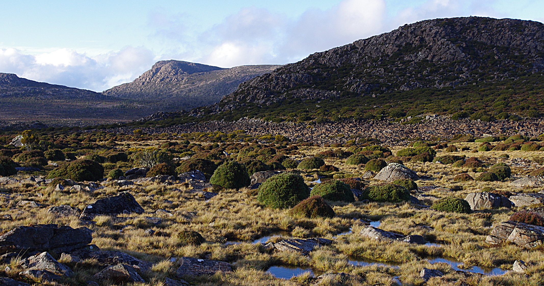
superb country. In the saddle below Forty Lake Peaks, looking towards Mt Ironstone
The north western end of the Central Plateau offers spectacular walking. Easy access to Lake McKenzie gets you into some of the most extensive alpine and sub alpine terrain in the state.
This heavily glaciated country is bounded on the north and west by big escarpments and deep valleys, and stretches off into more forested landscapes to the east and south. Two rough tracks get you into the Plateau proper, and there are endless possibilities for travel through this open and exposed mountain country.
This is a 4 day walk, which takes in the higher ridges of Turrana Heights and Turrana Bluff, through to the Long Tarns and back out via the Higgs Track.
The following news item comes from The Age newspaper, journalist Darren Gray.
Image: SMH
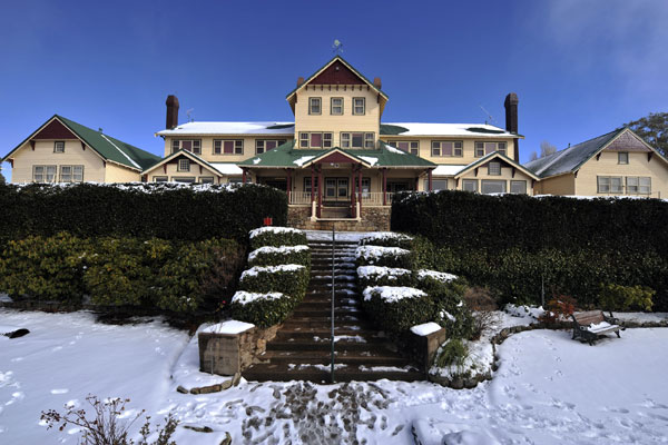
The grand old dame of Victoria’s alpine country, the Mount Buffalo Chalet, will reopen its doors once a $7 million project to refurbish the historic building and establish a day visitor centre and, hopefully, a cafe is complete.
The first clean-up works inside the 103-year-old chalet, closed since January 2007, are expected to start within weeks. But the project is more than a facelift, because outbuildings as well as some rooms that were not part of the original structure are likely to be demolished. Building assessments and recommendations will be carried out soon.
Environment Minister Ryan Smith will announce the project today and say the government is committed to preserving the building for future generations and ensuring ”the site is primed and ready for appropriate future investment.”
In an interview with Fairfax Media on Friday, he said the chalet was ”an icon in the area. It’s a state asset. We need to make sure that we can get people up there. I’m passionate about getting as many people into our parks as possible.”
Advertisement
”We want to make sure it’s useful, rather than just spending taxpayers’ money on maintaining something that’s not actually being used. So I think it’s important that we do get it back to some useable state.”
Mr Smith said the project, expected to take about a year, would pave the way for development, subject to national parks guidelines. Recent research found no private operator was interested in the site in its current state.
In about a year the government would call for expressions of interest for the site. ”Everything’s on the table, as long as it conforms to our guidelines around tourism development in these national parks,” he said.
Asked if the chalet could once again offer accommodation, he said: ”I’d leave it to commercial forces … But I’d look at anything. What I hope is that we get something that’s sustainable. I don’t want to look back in three years or five years or whatever and say ‘That didn’t work’.”
The works will be funded by a $4.7 million insurance payout for bushfire damage on Mount Buffalo and a contribution from the state’s Regional Growth Fund.
Mayor of the Alpine Shire, Peter Roper, said the project was ”absolutely fantastic news” that would be welcomed by locals.
The following story comes from the Summit Sun. Its good to know that pockets of Sassafras are hanging on at higher altitudes in the Snowies.
Environment specialists took to the skies recently to successfully confirm the presence of Southern Sassafras in the Bogong Peaks Wilderness in Kosciuszko National Park. The rugged mountainous country required a survey by helicopter to locate plants in forested gullies that flow towards the Goobragandra River.
Southern Sassafras or Atherosperma moschatum is a fire-sensitive tree. It has long been clouded in mystery regarding its existence in high altitude and cool temperate rainforest pockets like those found in the Bogong Peaks.
The survey was made possible thanks to a generous bequest by Kenneth Milburn to Landcare Australia, who have partnered with Greening Australia and the NSW National Parks and Wildlife Service (NPWS) to identify and map the distribution of the Southern Sassafras rainforest tree.
Shane Norrish, Farming and Major Projects Director at Landcare Australia said, “This is an outstanding opportunity to learn more about the ecology and distribution of high country vegetation communities. It is often difficult to obtain funding for projects such as these, and the generosity of the Milburn bequest will make a significant contribution to the protection of important species such as Southern Sassafras.”
Opportunistic surveys undertaken in 2011 by Greening Australia in the Bogong Peaks Wilderness Area confirmed the presence of Southern Sassafras further north-west than previously thought, but the extent was unknown.
“Identifying and broadening the known population boundaries of Southern Sassafras will have significant benefits for the species survival, and has important implications for park management activities including prescribed burning” said Matt White, NPWS Ranger for the Bogong Ranges.
Up until the time of the 2011 surveys, only a few populations were known to occur between 700-1300m altitude, and were usually found with Alpine Ash in sheltered gullies on the western fall of the main range of Geehi and Leather Barrel Creek, and in the Pilot Wilderness.
Further examination of remote sensing imagery had revealed additional potential occurrences in the Bogong Peaks, but limited access in the rugged terrain meant confirming these locations was almost impossible.
Greening Australia Project Manager, Nicki Taws, said, “The aerial survey enabled us to confirm the presence of Southern Sassafras in many locations that we couldn’t have reached on foot. We are very grateful to Landcare Australia for supporting this critical work.
Looking to the future, Nicki said, “We look forward to continuing our work with NPWS in this area, determining the presence and extent of Southern Sassafras and progressing collaborations to include community engagement in the protection and enhancement of this stunning tree.”
The Winter Wildlands Alliance created the Backcountry Film Festival in 2005 to help grassroots and professional filmmakers to show audiences their love of the winter outdoors. Since then, the annual festival has become something of an institution amongst many outdoor communities.
The festival is now a pre winter event here in Australia. Melbourne show
Wednesday May 15
At The South Melbourne Commons
corner of Bank & Montague St in South Melbourne
Suggested donation: $8 conc/ $12 waged
7pm. Come and grab a drink and catch up
7.30. Films start, the show runs til 10pm (with a 20 minute break in the middle).
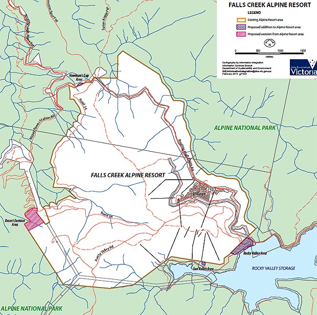
The Baillieu government has redrawn the boundaries of the Alpine National Park to allow the Falls Creek resort to expand.
On Thursday morning Environment Minister Ryan Smith announced the government would excise almost 10 hectares of land from the national park and add it to the adjoining Falls Creek Alpine Resort area.
The boundary change follows numerous requests from the Falls Creek resort to expand its operations. The resort wants to develop non-winter tourism activities and a high-altitude training camp for athletes.
The changes mean the resort will now be allowed to expand down to the shore of the Rock Valley Storage lake.
In exchange, the government will add almost 12 hectares of land on the slopes of Mount McKay to the park, which Mr Smith said contained snow gum woodland.
“Victoria’s alpine resorts make significant contributions to their local economies and to tourism in the state,’’ Mr Smith said.
‘‘This amendment is part of a long-term strategy to increase visitation, including in the non-winter months and ensure all Victorians can access and enjoy their natural environment,’’ he said.
“We want to encourage more altitude training, lake events, road cycling and mountain biking.’’
Mr Smith said the proposed amendments were part of Baillieu government’s plan to enable new ‘‘environmentally appropriate investments’’ on public land, including national parks, forests and alpine resorts.
In August the government decided to open up Victorian national parks to private tourism development following recommendations by the Victorian Competition and Efficiency Commission.
Guidelines to deem what development will be allowed in parks are still being finalised by Mr Smith, who will have final say over what projects would go ahead.
The decision to redraw the Alpine National Park boundaries to allow an expansion of the Falls Creek resort is separate to the August decision.
The Victorian National Parks Association’s Philip Ingamells said the process to redraw the Alpine National Park boundaries had been secretive.
“The government seems to think that if someone wants a development in a national park, they can simply excise that area from the park without any public consultation,’’ he said.
‘‘Management of our finest natural areas should be transparent, honest and based on the best scientific advice. We need to know what other developments they are planning for our magnificent national parks.”
Comment was being sought from Falls Creek Alpine Resort management.
The Alpine National Park was the site of the Baillieu government’s controversial cattle grazing trial, which was blocked by the Commonwealth under national environment law.
The Baillieu Government wants to give prospectors and fossickers more freedom to dig up our most treasured national parks.The government has directed the Victorian Environmental Assessment Council (VEAC) to recommend that prospectors and fossickers should be permitted to expand their activities into the Alpine, Yarra Ranges, Baw Baw, Croajingolong, Errinundra, Lake Eildon, Lind and Mitchell River national parks, as well as the Lerderderg State Park.
Fossicking is already allowed in a number of Box-Ironbark parks in central Victoria. But despite a requirement that park managers monitor the impact of this damaging activity, no assessment has been carried out.
In your own words, tell the government why our national parks should not be used for damaging activities like prospecting and gold panning.
Some suggestions:
Fossicking (metal detecting, digging holes and panning for gold) causes unnecessary damage to streamsides, and can threaten rare species such as ground orchids.
Our national parks are set aside to protect our natural areas for future generations. They are there for passive recreation, not exploitation.
Many of the rivers that flow through these parks are already listed as Heritage Rivers, and Natural Catchments. These additional levels of protection should be respected.
Fossicking is already allowed in a number of Box-Ironbark parks in central Victoria. But there has been no monitoring of their impacts as required by park management plans.
Fossicking and panning damages streamsides, causes erosion, and silts up rivers. In old gold-bearing streams, already worked over many years ago, mercury and other pollutants can be released into streams when soil is disturbed.
Fossicking and gold panning can damage the many important Aboriginal cultural heritage sites in the region.
While prospectors insist they behave responsibly, many don’t. The parks in the investigation area are in relatively remote areas, and fossickers’ activities will be difficult if not impossible to supervise or monitor.
Managing prospectors and fossicking will take park rangers away from other essential activities, at a time when staff numbers are already well below what’s needed for park management.
Many rivers, streams and catchments are important for rural, regional and city water supplies. We should be aiming to improve their condition, not compromise it.
There is already plenty of opportunity to fossick for gold in the extensive State Forest areas in eastern Victoria, outside national parks.
VEAC should have the opportunity to recommend no prospecting in parks, but the government has already decided that prospecting will be allowed in nine new parks (Alpine, Yarra Ranges, Baw Baw, Croajingolong, Errinundra, Lake Eildon, Lind and Mitchell River, and Lerderderg State Park).
Send your submission by Monday 18 February 2013 to:
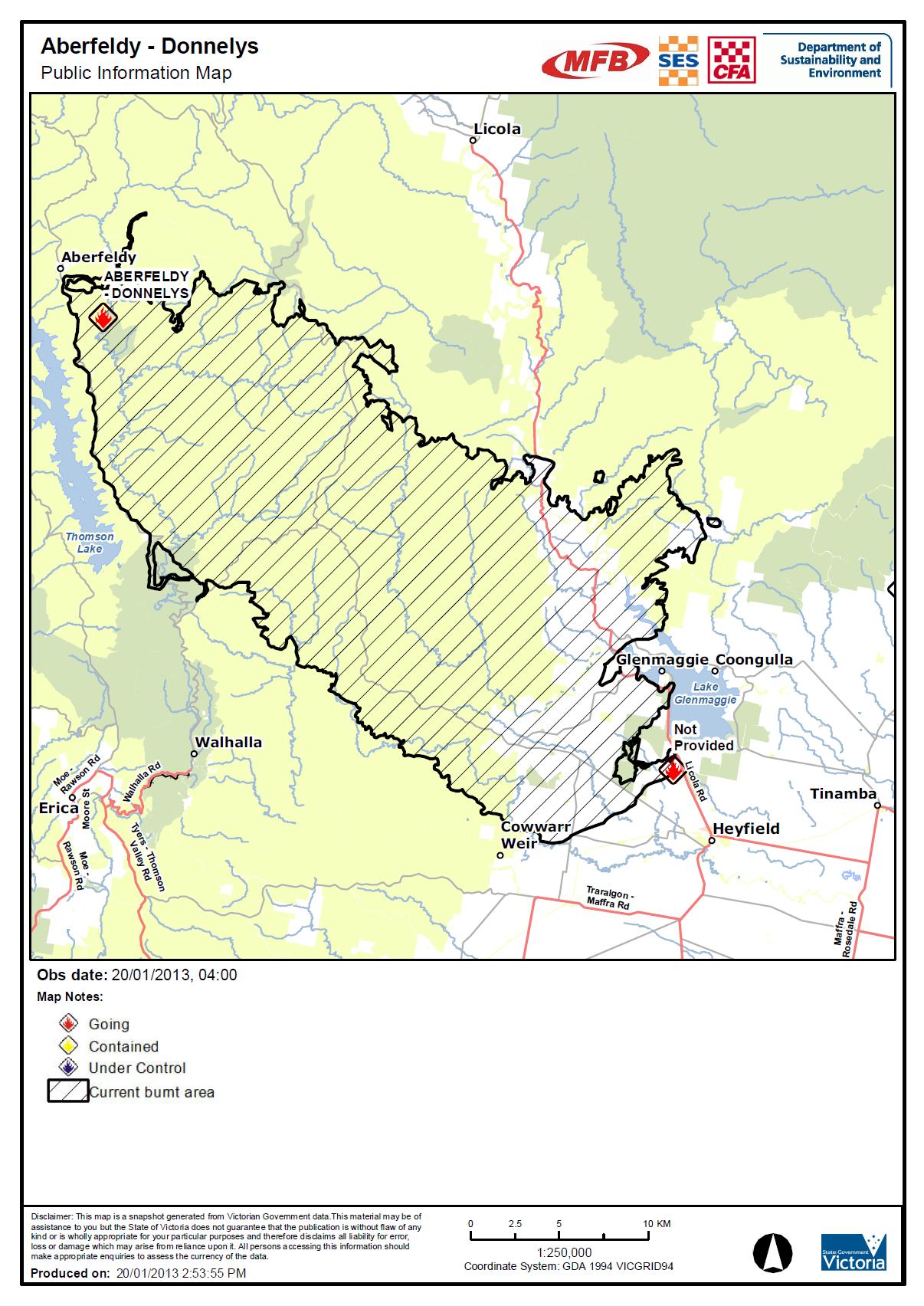
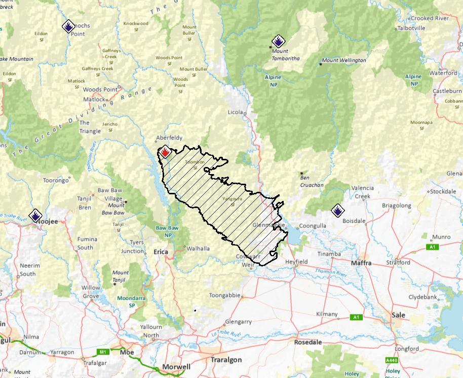
The main fire is the ABERFELDY – DONNELYS complex and it has already burnt more than 44,000 ha (as at 18 Jan). It started in the Aberfeldy area to the east of the Thomson Dam and Baw Baw plateau. It has now burnt east as far as the Licola road.
Check further down this page for updates on a fire that started Jan 21 in the north west spur area around Mt Feathertop.
UPDATE March 5:
VicRoads will open the Great Alpine Road to light traffic for the Labour Day long weekend, despite the ongoing maintenance and recovery works required after the Harrietville – Alpine North bushfires.
UPDATE, Feb 27: significant rain over the past day has greatly reduced fire activity across the Alps. The road from Heyfield to Licola has now been opened, as is the road from Omeo to Hotham Village.
The Great Alpine Road remains closed between Harrietville and Hotham and will remain so until further notice. Landslips on this road have added to the workload of removing ‘up to 10,000 fire killed trees’ along the GAR on this section.
Aberfeldy fire
UPDATE: Feb 15.
RECENT mild weather is helping suppression activities for the Aberfeldys-Donnellys fire and any more rain will ease conditions further.
The Aberfeldy fire has burned through 84,100 hectares and has a perimeter of almost 400 kilometres. Firefighters have constructed control lines on more than 300 kilometres of that perimeter by hand, with machinery and from the air.
Today, there are 295 personnel working on the fire, supported by 11 tankers, 87 slip-on units (4WD vehicles), 14 dozers and seven aircraft.
Further control lines are being constructed near the junction of Hickeys Creek Track and the southern end of Mt Margaret Track to protect the Avon Wilderness.
Backburning operations in the area will continue when weather conditions allow.
UPDATE: Feb 11:
The CFA reports:
Country Fire Authority and DSE advise that there is fire activity and suppression works in the Licola, Glenfalloch, Wollangarra, Glencairn area.
This bushfire is being controlled.
There is backburning on private property west of the Macalister River between Glenfalloch and Licola. Residents of Licola and surrounds may see active fire and there will be considerable smoke.
This message applies to the town of Licola and areas of Glenfalloch, Wollangarra and Glencairn.
This fire has burnt through approximately 82,522 hectares.
Control lines are being constructed on the Mt Margaret Track in an attempt to halt the easterly spread of the fire.
Machinery continues to work along the public-private interface north of Licola and around Glencairn.
Melbourne Water and DSE crews are patrolling on the south end of South Rd, near Mt Useful where back burning operations have been undertaken.
THE public can access Walhalla and Licola after a number of roads closed due to the Aberfeldy-Donnelly Fire were re-opened.
The fire is continuing to burn but is being controlled.
As Saturday morning, an area of 69,823 hectares has been burnt with a fire perimeter approximately 416 kilometres in length with 220km of control line built.
About 438 personnel, 150 vehicles, 21 dozers and 14 aircraft are involved in fighting the fire.
Among the roads opened include Licola Rd and Walhalla Rd only to the Thompson Dam Access Road.
UPDATE: Jan 27: The CFA reports that:
This bushfire is being controlled.
The fire has now burnt 71,000 ha.
UPDATE: Jan 25:ABC is reporting that ‘Towns to the south of the Aberfeldy bushfire could soon be under threat with northerly winds expected to strengthen overnight’.
Authorities remain concerned that hot winds could cause the Aberfeldy-Donnellys bushfire to jump control lines this morning.
The fire has now burnt 67,000 ha.
UPDATE: Jan 24. The CFA is reporting that the fire is being contained. Wind conditions have favoured crews working to build containment lines around the bushfire this morning, however, a predicted wind change is expected to challenge crews this afternoon.
The Alpine National Park and the Avon Wilderness Park are now officially closed.
DSE and CFA crews have been working to consolidate containment lines ahead of a predicted wind change on Friday afternoon.
The Aberfeldy bushfire is now around 62,000 hectares in size and has destroyed 22 homes.
Deputy Incident Controller Adrian Gutsche said a change forecast for the wind change had delayed the risk “by 12 hours”.
Mr Gutsche said crews had been working to consolidate firebreaks and control lines to the south of the fire zone ahead of a predicted wind change on Friday.
UPDATE: Jan 23. The CFA reports that the fire has now burnt 63,233 ha. There will be ‘aerial ignition within control lines east of Walhalla occurring today’ and additional control lines on the Walhalla – Cowwarr road.
UPDATE: Jan 22. The CFA reports that ‘this bushfire is being controlled.
The Aberfeldy Road is closed north of Beardmore.
Burning out operations are continuing north east of Walhalla and east of Aberfeldy.
There was increased fire activity north of Walhalla overnight’
About 600 crews, 130 vehicles and 13 aircraft are involved in fighting the fire, which is now 61,783 hectares in size with the fire perimeter now 322 kilometres.
Fire behaviour is expected to increase slightly as the temperature rises during the day and crews will continue backburning operations and building containment lines.
A critical 190 hectare backburn will reduce fuel loads in the unburnt area 5km south of Glenmaggie and 6km north-west of Heyfield. Smoke will be visible from surrounding communities.
UPDATE. Jan 21. The access to the mountains via Licola are still closed off. Restricted access has now been restored to Licola Rd, all the way from Licola to Heyfield.
Residents of the immediate area; people providing recovery and relief services, council or VicRoads employees or sub-contractors, and business owners in the immediate area can now access Licola.
Victoria Police has reiterated that many roads in the Seaton, Glenmaggie and Heyfield area are restricted to local access only.
Police will be actively patrolling the area and have asked drivers to take care on the roads and avoid unnecessary travel, particularly in fire-affected areas.
Department of Sustainability and Environment conducted a 180 hectare backburn Sunday morning in an unburnt area five kilometres south of Glenmaggie and 6km north-west of Heyfield.
This fire will remain active into Monday and possibly longer.
UPDATE. Jan 20. The Department of Sustainability and Environment advise that there is a planned 180 hectare back burn occuring in the Heyfield District area. The fire is still being contained. It has burnt 57,726 hectares.
UPDATE. As of Jan 19, the fire is still moving and has burnt out 52,669 ha.
The fire as at 19 Jan. Despite some claims from the usual (anti green) sources, the fire didn’t start in a national park.
At this point (Jan 18) this is the only significant fire burning near the high country. There were media reports earlier in the day that this fire complex was heading for the Avon wilderness.
TEN Licola locals are trapped as an out-of-control bushfire heads towards the township.
Victorian Fire Services Commisioner Craig Lapsley confirmed 90 school children at a camp in Licola had been relocated to Traralgon safely but ten locals remained isolated in the town.
There are five fire crews with the residents battling the blaze which is expected to hit between 4pm and 6pm this afternoon.
The Licola Rd has been closed since this morning leaving remaining residents no way to leave.
The blaze is now more than 44,500ha in size and creating spot fires 2-4km in front of it.
Mr Lapsley warned the fire, which still also threatens the townships of Seaton, Heyfield and Glenmaggie, could burn for as long as two weeks if mother nature was not kind.
“This has the potential to be a two-week fire fight,” he said.
“We would hope this weekend would be kind to us but there is no rain forecast.
“Without rain or moisture it’s very hard to bring it to a controlled position.”
He described the fire as difficult and unpredictable and said as the blaze spread into remote bushland it got harder to control from the ground.
There are more than 70 firetrucks, about 200 firefighters and 13 helicopters working to control the fire.
Five homes have already been destroyed in Seaton.
Heyfield incident controller Laurie Jeremiah told a media briefing at Seaton this morning that five homes were believed to have been burnt at Seaton and a family had been trapped in their house but were able to escape.
Mr Jeremiah also confirmed a fire tanker had been burnt.
The crew members took shelter in the vehicle while the fire went over and escaped unharmed, he said.
Mr Lapsley said the extent of damage to livestock and farm land was still unclear but would unfold in coming days and weeks.
“There will be damage to fencing and there will have to be damage to livestock,” he said.
“(Damage to livestock) is not something we have been able to calculate but there will be losses in those areas.”
The Harrietville–Alpine South fire has not spread much overnight, but there will be increased smoke visible from communities today as backburning operations progress.
The fire is now 12,130 hectares, with a perimeter of 228 kilometres.
The fire continues to burn in steep, rugged terrain with limited access for on-ground fire fighter crews.
Ongoing asset protection, suppression and patrolling activities continue around Mt Hotham, Dinner Plain and Dargo.
Areas of sensitive natural values including cultural heritage places, threatened species and critical breeding habitat have been identified and protective works undertaken.
Combined, the north and south fires are 30,400ha.
The Great Alpine Rd has reopened to the public from Dinner Plain towards Omeo yesterday at 7pm. From Mt Hotham to Dinner Plain, access is restricted to residents, essential services, accredited media and individuals or groups delivering relief and aid to residents and to animals.
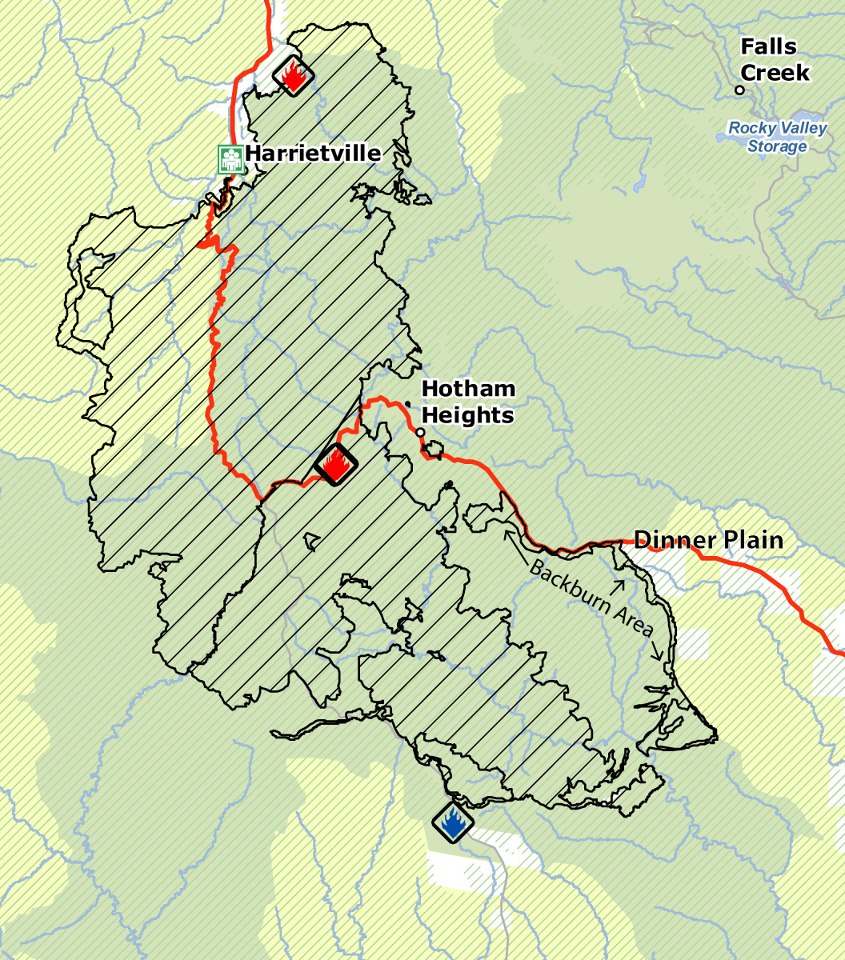
UPDATE: Feb 13. Backburning continues to protect Dinner Plain. The southern fire front is moving roughly south eastwards, to the south of Dinner Plain.
the fire, showing recent back burning lines around Dinner Plain, as at 12 Feb
THE Harrietville-Alpine fire remains active in the Dargo River valley area north of Dargo, however moist and cooler weather conditions have resulted in a decrease in fire activity.
The Harrietville-Alpine South fire is about 7127 hectares, and is not yet under control. With the north and south areas combined, the Harrietville-Alpine fire is 23,411ha.
The focus of firefighters is on both asset protection and back burning to contain the fire.
Back burning work is likely to continue for at least the next week. Residents and visitors to the area are asked to take extra care when travelling on local roads, as they are likely to experience increased smoke across roads and in the community, increased firefighting activity, and a greater number of emergency vehicles travelling in the area.
Back burning operations began Sunday afternoon along the southern edge of the Great Alpine Rd from the Alpine Resorts Commission entrance between Dinner Plain and Mount Hotham Resorts down to Dinner Plain Track.
Road closures remain in place, and anyone intending on travelling in the area should check with VicRoads for any updates.
The Great Alpine Rd is closed between Harrietville and Dinner Plain.Dargo-High Plains Rd is closed between the Great Alpine Rd and Dargo until further notice. Access to forests and parks north of Dargo is restricted as a result of this closure.
The Alpine National Park is closed east of Harrietville extending along Westons Spur Track to the Australian Alps Walking Track to Pretty Valley Track, then south to the Great Alpine Rd to the boundary of the Alpine National Park and Dinner Plain State Forest.
Mount Feathertop and its approaches are closed.
State Forest north of the fire area including the West Kiewa is also closed.
UPDATE. Feb 8. After a few days of continued fire control and mild conditions, fire activity has heightened considerably, putting Hotham village at direct risk. The fire is now operating on two main fronts. The fire was previously referred to as the ‘Harrietville – Feathertop Fire.’ It has been split into two fire sectors – the ‘Harrietville – Alpine North Fire’ and ‘Harrietville – Alpine South Fire’.
See below for update from Mt Hotham management:
The ‘Harrietville – Alpine Fires’ remains classified as ‘going’, no asset losses have been reported to date.
The wind direction has remained ‘NNW’ all day and with a wind speed of 30 kmh with gusts up to 50 kmh. Humidity is low at 33%.
Harrietville – Alpine South’ fire is firmly established in the ‘Dargo’ and has increased in size significantly during the course of the day. The fire is visually prominent SW of the village, along ‘Morning Star Spur’ and below ‘St Bernard’ and is moving up toward Baldy Creek to the SW of the resort centre. This fire activity is of concern – heavy aerial water bombing has been undertaken all day so as to prevent the fire moving into Baldy Hollow (immediately below the Village Centre and Summit). One Erickson Skycrane and two bucket equipped heavy lift helicopters with have been refilling from the snowmaking dam at Loch every 7 minutes all day. Dam capacity has been maintained. CFA/DSE expect the ‘Alpine South Fire’ to make further SSE runs in the untracked forest of the ‘Dargo’ until at least late Sat/early Sunday given the predicted weather conditions.
The control strategies for this part of the fires are limited due the dense nature and ruggedness of the terrain. The ‘Swift’s Creek’ ICC has indicated an ‘indirect attack/asset protection’ strategy aimed at keeping the main fire east of the ‘Dargo High Plains’ Road.
The ‘Harrietville – Alpine North’ fire continues to move through high elevation forest that was burnt in 2003 and 2006. The fire has now burnt down to the ‘Diamantina River’ along a 500m stretch – which proposes a potential threat to the Resort Water Catchment. Resort Management staff have observed smoke continuing to rise from the ‘Diamantina Area’, which indicates that the fire is still active, despite aerial suppression. CFA/DSE have reported that the hot edge on the Diamantina River continues to hold west of the river, but many hot spots remain, right down to the river bank. Felled timber on the helipad has delayed insertion of crews this morning, but crews are now working after the pad was aerial bombed. Options for providing water-pumping capability for ground crews to black out this edge are being explored
An aerial infrared scan (FLIR flight) this morning showed going fire continuing to back down in a westerly direction into the West Ovens and the upper part of the East Buckland catchments. The fire is also continuing to burn slowly down steep slopes into the headwaters of the Dargo catchment. It has reached the upper reaches of the Dargo River in some places and has uphill runs available to it once it crosses. The fire has burnt in a broad front southward along both sides of the Dargo High Plains Road. A further aerial FLIR scan will be flown this afternoon if time and conditions permit.
Note: A ‘Watch & Act’ message for Hotham and Dinner plain remains in place and ‘Advice messages’ for Harrietville, Dargo, Cobungra, Omeo, Swifts Creek and Ensay.
Today, Saturday and Sunday are classified ‘high-risk’.
UPDATE. Feb 6. Backburning has been carried out south of Harrietville and along the Great Alpine Road on the south western side of Hotham summit in recent days.
CFA reports that:
This fire is yet to be contained
Fire activity has increased significantly this afternoon and increased smoke will be evident.
The fire has the potential to cross the Great Alpine Road approximately 12 kilometres south of Harrietville heading in a westerly direction.
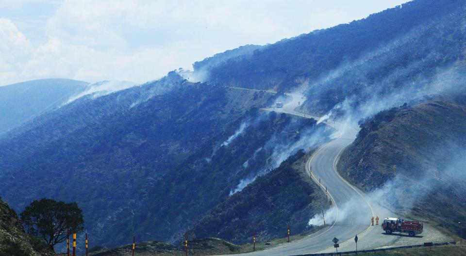
Back burning along the Great Alpine Road near Baldy Hollow. Image: Dinner Plain Alpine Village facebook
UPDATE: Feb 3. The Harrietville-Feathertop fire has now burnt more than 6,100 hectares of the Alpine National Park.
Alpine National Park is closed east of Harrietville extending along Westons Spur Track to the Australian Alps Walking Track to Pretty Valley Track, then south to the
Great Alpine Road to the boundary of the Alpine National Park and Dinner Plain State Forest. Mount Feathertop and its approaches are still closed.
Backburning will be carried out to the south of Harrietville between Old Coach Road and the East Ovens River.
The Great Alpine Road is still closed between Harrietville and Dinner Plain.
UPDATE. Feb 1. Spot fires occured within Hotham Village and have all now been controlled. However, CFA reports that the main fire is still not yet under control.
This bushfire is approximately 5000 hectares in size and is out of control.
The Hotham Dinner Plain community meeting will be held at 3pm Saturday February 2 at Rundells Alpine Lodge Dinner Plain.
The Great Alpine Road is closed between Harrietville and Dinner Plain and the Dargo High Plains Road is closed.
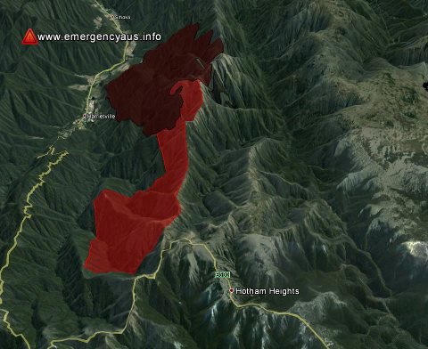
The Feathertop fire as of Jan 31
UPDATE. Jan 31. After a quiet few days, the fire is again threatening surrounding towns. The CFA reports:
There is a large, fast moving bushfire in the Mount Hotham and Hotham Heights area. It is travelling in asouth– south westerly direction.
This fire is expected to impact anytime within the next hour.
This bushfire is approximately 4100 hectares in size and is out of control, currently creating spot-fires approximately 2-3km/s ahead.
Relocation is not advisable. If required head to the neighborhood safer place.
UPDATE: Jan 28. The same as yesterday (see below). Additionally, the CFA advises that:
The Alpine National Park is closed east of Harrietville, west of Mt Cope, south of Mt Jim and north of the Great Alpine Road
UPDATE: Jan 27. The CFA reports that:
There is still fire activity near Harrietville township. This fire is yet to be contained and considerable work will be occurring over coming weeks. The Great Alpine Road and the Dargo High Plains Road are now open. Motorists are urged to use caution as emergency vehicles will be in the area.
Hotham Heights is not listed as being at risk at present, the main focus is around Harrietville. The fire has burnt an area of around 3,000 ha.
UPDATE: Jan 25: ABC reports that ‘Strong northerly wind gusts of up to 90 kilometres per hour are fanning the flames of two bushfires burning in Victoria’s east. The winds are expected to intensify a fire in the Alpine region near Harrietville and Hotham Heights‘.
A watch and act alert remains in place for both of those communities.
Overnight there has been benign fire behaviour, with limited spread of fire since midnight. A short section of fire has continued to back down to the control line around private property north of Harrietville, but has not caused control problems. The weather forecast indicates that Mt Hotham could be impacted by fire in the next 24hrs
UPDATE: Jan 24. The CFA report that the fire is still moving rapidly, and it is travelling in a south easterly direction.
This fire is expected to impact Hotham Heights, Harrietville anytime within the next 24 hours.
There is no evacuation order for Harrietville. Residents without fire plan are being advised to leave by 6pm today. A Watch and Act notice remains in place for the communities of Hotham Heights and Dinner Plain.
This fire is expected to impact Falls Creek, Hotham Heights, Harrietville anytime within the next 24 hours.
The Great Alpine Road is closed between Harrietville and Hotham Heights.
UPDATE. Jan 23. The fire has continued overnight and the great alpine road is still closed, as are a number of parks in the area plus the Alpine National Park in the Feathertop vicinity. Check here for all closures.
Emergency services safely evacuated 37 hikers from the Mt Feathertop – Razorback walking tracks via helicopter.
The fire has burnt around 850 hectares in steep, dense bushland.
While no towns are directly under threat at this stage, fire services will closely monitor the fire and work hard to build containment lines today ahead of severe fire danger tomorrow.
UPDATE. Jan 22. 5pm. CFA are now advising:
This is a large, fast moving bushfire. It is travelling in a south easterly direction.
This fire is expected to impact Davenport Village, Falls Creek, Hotham Heights, Harrietville, Smoko anytime within the next 6 to 24 hours.
The great alpine road is closed between harrietville and Hotham Heights
Bushwalkers and other forest users are advised to avoid walking tracks in the Alpine National Park east of Harrrietville
It is described as being in the RAZORBACK NORTH WALKING TRK area, above the towns of Smoko, Freeburgh, and Harrietville.
Although described by the CFA as being ‘small’ the fire caused the Great Alpine Road to be closed on Jan 22.
A number of other small fires were reported on Jan 21 and 22 in the area, including one near Tawonga South and one near Falls Creek.
Kronicle is the world’s first backcountry snowboarding/ spiltboard magazine:
“Kronicle is a backcountry snowboard publication tailored to riders with a thirst for untracked snow, untapped lines, and exploration. We’re employing the richest stories, images and design to chronicle the people and places of backcountry snowboarding. That’s not all—we also report on the gear and skills riders need to reach their mountain objectives.
During its relatively short lifespan, snowboarding has covered a lot of ground and backcountry is the next frontier. It’s a homecoming of sorts, coming back to where it all began, bringing the sport full circle and leading us to Kronicle. This is our story, and it’s just the beginning”.
It is produced by Height of Land Publications in the US, who produce the excellent Backcounrtry magazine and, for many years, Telemark magazine. HOL produces high quality, visually gorgeous publications and Kronicle is a nice addition to their existing magazines.
Kronicle have teamed up with FirstLight Snowboards to provide this to the Australian Splitboard community.
The Baillieu Government has asked the Victorian Environmental Assessment Council (VEAC) to make recommendations to introduce recreational prospecting into sections of up to nine national parks in eastern Victoria.
Importantly:
VEAC cannot recommend that there should be no prospecting allowed in the parks, even if it reports that such activity would be harmful to the parks.
VEAC has been given a very short time to gather evidence and make appropriate recommendations, indeed this will be the shortest ever VEAC investigation, and will largely take place over the holiday period.
Prospecting with metal detectors can erode streamsides, harm rare plants and spread pathogens such as Phytophthora and Chitrid Fungus. But evidence-based information relating to both the impacts of fossicking and the complex geology of Victoria is not readily available. More time is definitely needed for this investigation.
There will be no draft report, and only one period of public consultation.
Please write to VEAC, Victoria’s environment minister, and our energy and resources minister, saying:
The terms of reference are flawed, because VEAC is forced to introduce fossicking to eastern Victorian parks, even if it decides the activity is harmful.
There is no demonstrated high interest in fossicking in the eastern part of Victoria, even though vast areas of state forest are already available for that activity.
There is absolutely no urgency for this investigation, so there is no need for such a tight timeline (and VEAC’s resources are already stretched, with two current investigations – Marine Parks and Yellingbo).
For more information, read the article Prospecting in Wonderland by Phil Ingamells in the latest edition of our magazine Park Watch.
For details of the investigation visit the VEAC website.
TAKE ACTION
Please, send a message now to Victoria’s environment minister, Ryan Smith, and the energy and resources minister Michael O’Brien saying that you are not happy with the restrictive terms of reference for this investigation, and that the timeline is far too short.
Please add your own concerns, and any of the information above.
Hon Michael O’Brien
Minister for Energy and Resources
Email: michael.o’brien@parliament.vic.gov.au
Hon Ryan Smith
Minster for the Environment and Climate Change
Email: ryan.smith@parliament.vic.gov.au








Recent Comments